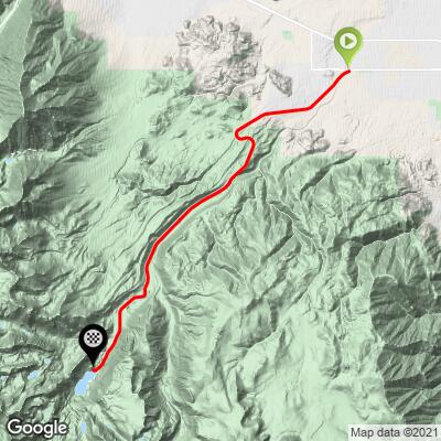
29.3
PDI
15.7 mi
DISTANCE
4,824 ft
GAINED
5.7 %
AVG. GRADE
FULL CLIMB STATS
INTRO
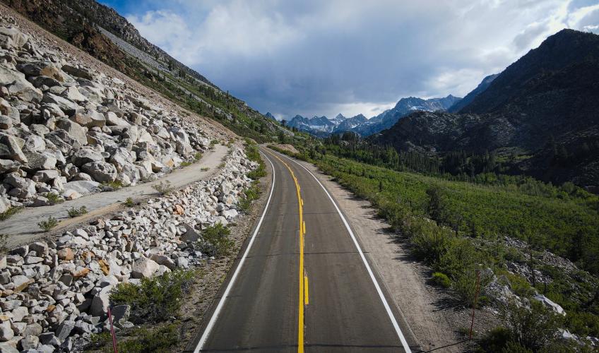
“A very big hill on the eastern slope of the Sierra Nevada, this one is fairly shallow over the first two miles, the grade steadily increasing up toward Lake Sabrina with big views down into the valley. Soon a big S curve indicates increasing grade on its upper end as you gain altitude. After the curve the road straightens a bit and again heads towards the mountains to continue over solid grade, the most extended stretch of continuous solid grade on the hill. Soon the slope goes up and down a bit as you head toward steep and scenic high mountain peaks. Several miles before you reach the South Lake junction (which you pass on the left just under 12 miles in) you again find more stout grade..." (This quote is presented with the approval of John Summerson, from his book, The Complete Guide to Climbing (by Bike) in California, pg. 118.)
PLAN YOUR ROUTE
5.8% average grade (6.2% climb only). 58% of the climb is at 5-10% grade and 6% is at 10-15%. The steepest quarter-mile is 10.7% and steepest mile 9.1%.
See more details and tools regarding this climb's grade via the “Profile Tool” button.
Roadway: All but the last half-mile of the climb is on Highway 168 which is in excellent condition. The last half-mile is paved and on rougher but easily manageable narrower roadway up to Lake Sabrina. For road conditions see Inyo County Road Open/Closed Status.
Traffic: The first half of the ride traffic is moderate. Traffic thins as we climb and is not a problem over the last half to third of the climb. Those who are traffic averse may be uncomfortable on this ride.
Parking: We either ride from our hotel in Bishop or park just off Highway 168, or on on Red Hill Road at the climb start - Map; Street View.
Note: Check weather conditions with the Inyo National Forest Service for each climb you intend to do and the Inyo County road conditions website before traveling to Owens Valley to cycle anytime after September or before June.
Provisions: None on the route until the finish. If it is open, you can get a meal at Lake Sabrina Landing Café at the finish of your ride - Map; Street View.
Altitude: You climb above 9,000' where you have 27% less oxygen than at sea level so be aware of those effects as you climb.
Before heading out on any cycling adventure check out our Things to Bring on a Cycling Trip and use our interactive check list to ensure you don't forget anything.
Also consider climbing up to South Lake - the turn off is four miles back down the hill from our Lake Sabrina Finish. The 7.2 miles from the turn off onto South Lake Road to the finish is at 5% average grade to elevation 9,830'.
Use the “Routes in Area” button on the menu bar to see other bike climbs in this area.
When we are riding the climbs in Owen's Valley, CA, particularly those in the central and northern end of the valley, we prefer to stay in Bishop.
ROUTE MAP
MEMBER RATING
CURRENT WEATHER
PJAMM TRIPS ADVENTURE STARTER BUNDLES
Check out PJAMM Adventure's prepackaged (self-guided) cycling trips. They will help you plan, document and conquer your next adventure.
NEARBY CLIMBS (0) RADIAL PROXIMITY
FROM No Climbs Found
MEMBER REVIEWS & COMMENTS
Let us know what you thought of this climb. Signup for our FREE membership to write a review or post a comment.
Already have an account?
LOG IN HERE
Skotscott
September 5, 2023
Lots of separation cracks the entire way up - last mile is better and a nice punchy climb to finish. A bit jarring on the way down but the high speed helps with the cracks. Moderate traffic whizzing past at high speeds with narrow shoulder and 55mph speed limit. Mostly courteous drivers passing wide. Great views on the way up and at the lake. There is a small cafe/shop on top with basics. Hot climbing up and chilly on the top. Used a wind jacket on the way down.
carlinguernsey
This is a long difficult climb with varying gradient. I did it in late May and there was significant snow on the ground at the lake (but the road was clear). You can start from anywhere in Bishop.