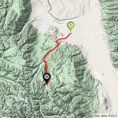
33.2
PDI
18.9 mi
DISTANCE
5,561 ft
GAINED
5.5 %
AVG. GRADE
FULL CLIMB STATS
Page Contributor(s): Ron Hawks, Las Vegas, Nevada, USA
INTRO
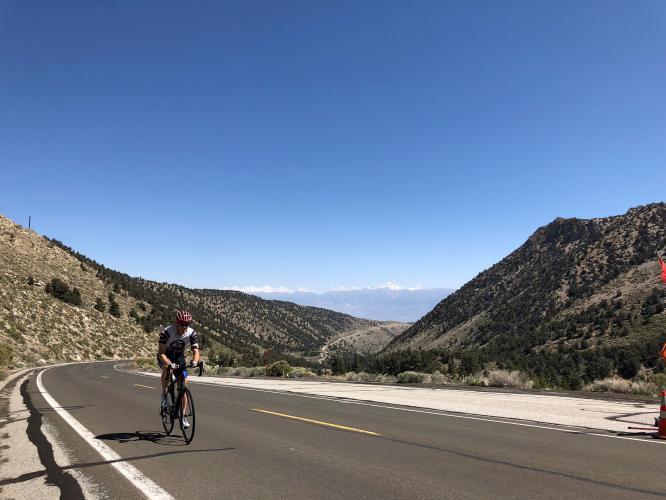
close in a bit and the roadway narrows. Soon you encounter several steep sections with grades running from 10-14%. The torture is short lived howeer as the grade eases and the trees part just beofre the very top. The scenery is amazing on this section and the climb mercifully ends just above the stunning namesake lake at the end of the upper parking lot (route dead ends) at almost 10,000 feet.” (This quote is presented with the approval of John Summerson, from his book, The Complete Guide to Climbing (by Bike) in California, pg. 118.)
PLAN YOUR ROUTE
The average grade of this climb is a healthy 5.4% (5.9% with descent eliminated from the gradient equation). The grade is never overwhelming, but it is made more challenging by the high altitude we ride to - the climb ends at nearly 10,000' where we have 30% less oxygen. 6.8 miles (36%) of the climb are at grades 0-5%, 9.7 miles (52%) are at 5-10%, and 1.2 miles (6%) are in the 10-15% range. None of the climb is above 15%. The steepest quarter-mile is 12.5% and steepest continuous mile is 8.9%.
See more details and tools regarding this climb's grade via the “Profile Tool” button.
Roadway: The first 11.7 miles on the highway is excellent. There is not much if any shoulder to ride in, but there are no visual obstructions to drivers on this part of the climb and we felt fairly safe the five times we have ridden up this route. The final seven miles are on paved road that can be somewhat rough at times, but it is still good roadway. Inyo County Road Open/Closed Status.
Traffic: Moderate for the first few miles on Highway 168 and minimal on South Lake Road.
Parking: We either ride from our hotel in Bishop or park just off Highway 168 or on on Red Hill Road at the climb start - Map; Street View.
Note: Check weather conditions with the Inyo National Forest Service for each climb you intend to do and the Inyo County road conditions website before traveling to Owens Valley to cycle anytime after September or before June.
Provisions: There are no provisions on the climb until you get to the Bishop Creek Store and Restaurant at mile 14 on South Lake Road.
Before heading out on any cycling adventure check out our Things to Bring on a Cycling Trip and use our interactive check list to ensure you don't forget anything.
Also consider riding to Lake Sabrina which shares its first 11.7 miles with the South Lake climb. The finish up to South Lake is 4 miles at 6.1% after you pass South Lake Road.
Use the “Routes in Area” button on the menu bar above to see other bike climbs in this area.
ROUTE MAP
MEMBER RATING
CURRENT WEATHER
PJAMM TRIPS ADVENTURE STARTER BUNDLES
Check out PJAMM Adventure's prepackaged (self-guided) cycling trips. They will help you plan, document and conquer your next adventure.
NEARBY CLIMBS (0) RADIAL PROXIMITY
FROM No Climbs Found
MEMBER REVIEWS & COMMENTS
Let us know what you thought of this climb. Signup for our FREE membership to write a review or post a comment.
Already have an account?
LOG IN HERE
carlinguernsey
I liked this climb, except for the last mile or so. The gradients really ramp up and there are a couple of short descents thrown in to trick you into thinking that you’re near the finish. You can really get moving on the way down!
Skotscott
September 5, 2023
First 12 miles gradually gets steeper. Lots of separation cracks during the first 12 miles. Not an issue going up but a bit jarring on the way down. First 12 miles are also on a road with a narrow shoulder and 55 mph speed limit. Moderate traffic all blasting past - mostly giving lots of room but 2 passed very close. Not a fan of the first 12 miles. However, the last 7 are on a new road with wide shoulder, lower speed limit and less traffic. Some stout climbing near the top and fantastic views on the way up. Hot temps on the way up but cool on top.
Jghanaie


This is a favorite for me that I like to do in the fall. They have recently redone the road and it gets better once you turn off onto S Lake. It is great temps and beauty with the aspens if you go during fall! Also probably less traffic.