![Cycling Wachusett Mountain North, Massachusetts Cycling Wachusett Mountain North, Massachusetts - PJAMM Cyclist stands on bike looking out over low retaining wall over fall foliage to greenery below]()
Cycling Wachusett Mountain North, Massachusetts.
Ride 3.6 miles gaining 1,156’ at 5.8% average grade.
There are two parts to this climb: (a) The first 1.4 miles on Mountain Road, which carry a moderate amount of traffic, and (b) the last 2.4 miles into Wachusett Mountain State Reservation along a great road with mild traffic and beautiful surroundings.
![Cycling Wachusett Mountain North, Massachusetts Cycling Wachusett Mountain North, Massachusetts - bike parked in field surrounded by fall foliage, two-lane road with fall foliage, PJAMM Cycling logo in corner]()
Wachusett Mountain North is the ninth hardest bike climb in Massachusetts.
“Wachusett Mountain is likely the most popular ascent of any meaningful length in Massachusetts as it lies quite close to the Boston metro area. It begins over solid grade and soon you enter woods. At mile 1.3, turn right into the State Reservation to continue. Here you encounter a flat/descent before climbing resumes over shallow and then variable grade. Soon the road becomes one way at a flat. The next section has more challenging pedaling along with a descent. Where the road comes back together, turn left to find steeper grade for the final pitch up to the summit where the climb soon ends at a small parking area.” (This quote is provided with the approval of John Summerson from his book The Complete Guide to Climbing (by Bike) in the Northeast, pg. 81.)
![Cycling Wachusett Mountain North, Massachusetts Cycling Wachusett Mountain North, Massachusetts - PJAMM Adventure App shows climb grade and profile]()
PJAMM Adventure App showing details at the beginning and finish of the climb.
![Cycling Wachusett Mountain North, Massachusetts Cycling Wachusett Mountain North, Massachusetts - bike parked next to sign for Wachusett Ski Area, views along the climb, PJAMM Cycling logo in corner]()
The first 1.2 miles on Mountain Road.
The climb is just north of Princeton and the closest significant bike climb to Worcester (20 miles line of sight) and Boston (40 miles).
![Cycling Wachusett Mountain North, Massachusetts Cycling Wachusett Mountain North, Massachusetts - bike parked in front of sign for Wachusett Mountain Ski Area, buildings at Ski Resort area]()
Wachusett Mountain Ski Area at 0.6 mile up Mountain Road from the start.
Skiing on the mountain dates back to the 1930s.
![Cycling Wachusett Mountain North, Massachusetts Cycling Wachusett Mountain North, Massachusetts - toll booth to enter Wachusett Mountain State Reservation, fall folige, PJAMM Cycling logo in corner]()
$5.00 to enter the Wachusett Mountain State Reservation as of October 2020.
![Cycling Wachusett Mountain North, Massachusetts Cycling Wachusett Mountain North, Massachusetts - sign reads "Please Keep Off Slopes"]()
We pass by ski slopes and under lifts on our way to the top.
![Cycling Wachusett Mountain North, Massachusetts Cycling Wachusett Mountain North, Massachusetts - fall foliage, bike parked under ski lift, PJAMM Cycling logo in corner]()
Views along the climb between the entrance and the top.
![Cycling Wachusett Mountain North, Massachusetts Cycling Wachusett Mountain North, Massachusetts - Harlow Lookout]()
Harlow Lookout is on the one way descent from the Summit (about a mile from the top).
![Cycling Wachusett Mountain North, Massachusetts Cycling Wachusett Mountain North, Massachusetts - view from Harlow Lookout shows dense forestation, fall colors, and the Boston skyline far in the horizon]()
On a clear day, you can see Boston from Harlow Lookout.
SUMMIT
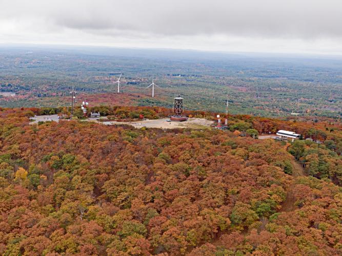
![Cycling Wachusett Mountain North, Massachusetts Cycling Wachusett Mountain North, Massachusetts - aerial view from the summit shows 360 views of fall foliage, PJAMM Cycling logo in corner]()
Aerial views of the summit.
![Cycling Wachusett Mountain North, Massachusetts Cycling Wachusett Mountain North, Massachusetts - observation tower at climb's summit, PJAMM Cycling logo in corner]()
There is an observation tower at the summit.
There are information boards for each compass direction at the lower level of the tower. The boards show and name distant mountains and peaks. From this point, on a clear day you can see Mount Monadnock, Mount Greylock, southern Vermont, and on a good day, Boston.
![Cycling Wachusett Mountain North, Massachusetts Cycling Wachusett Mountain North, Massachusetts - informational signs looking North from summit]()
![Cycling Wachusett Mountain North, Massachusetts Cycling Wachusett Mountain North, Massachusetts - informational signs looking East from summit]()
![Cycling Wachusett Mountain North, Massachusetts Cycling Wachusett Mountain North, Massachusetts - informational signs looking south from summit]()
![Cycling Wachusett Mountain North, Massachusetts Cycling Wachusett Mountain North, Massachusetts - informational signs looking West from summit]()

 We've partnered with Sherpa-Map.com to bring you the best route planning tool. With a PRO Membership you can use this climb as a reference when creating your route.


