Pack Monadnock Bike Climb - PJAMM Cycling

7.2
PDI
1.2 mi
DISTANCE
765 ft
GAINED
12 %
AVG. GRADE

FULL CLIMB STATS

Page Contributor(s): John Summerson, The Complete Guide to Climbing (By Bike), 2nd Edition

INTRO

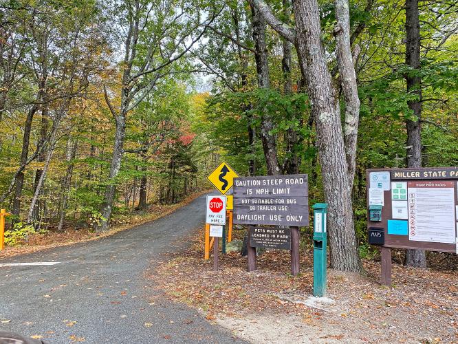
The climb is within Miller State Park (533 acres, established 1891), the oldest state park in New Hampshire. There is a fee for everyone entering the park, including cyclists ($4 as of October 2020). There are very few distant views along the climb as it is bordered by thick forest throughout. This is not a disadvantage during leaf peeping season.

PLAN YOUR ROUTE

We've partnered with Sherpa-Map.com to bring you the best route planning tool. With a PRO Membership you can use this climb as a reference when creating your route.
12.1% average grade - 770' climbed in 1.2 miles with 0 descent.  28% of the climb is at 5-10% grade, 48% is at 10-15%, and 24% is at 15-20%.  The steepest quarter-mile is 15%.

See more details and tools regarding this climb's grade via the “Profile Tool” button.
Roadway:  This is a narrow two lane road in fair condition with no center striping or shoulder.

Traffic:  Light. 

Fee:  There is a fee to enter the park on a bike ($4 in 2020).

Parking:  Ask the ranger if you can park outside the gate on the side of the road, where there is plenty of space (Map). 
Provisions:  There is no place to get food or water on this route.  There are several places for food/beverages in Peterborough, five miles west of our start (Map). 
Before heading out on any cycling adventure check out our Things to Bring on a Cycling Trip and use our interactive check list to ensure you don't forget anything.
Spend some time at the five star rated Miller State Park before or after your ride (Google Map + Reviews).  You can also check out this All Trails Top List of Hikes in Miller State Park.  Consider driving south and including Wachusett Mountain climbs in your day as they are only about 30 miles away: Wachusett Mountain East and Wachusett Mountain North.

ROUTE MAP

MEMBER RATING

Difficulty: Strenuous
3
Road
4.7
Traffic
3.7
Scenery

CURRENT WEATHER

PJAMM TRIPS ADVENTURE STARTER BUNDLES

Check out PJAMM Adventure's prepackaged (self-guided) cycling trips. They will help you plan, document and conquer your next adventure.
ALL TRIPS
Browse all of our prepackaged trips and find your next adventure!
Mt. Washington Auto Road Race
United States (MA,ME,NH,VT)
3 ROUTES
23 POIs
ROUTE STATS (TOTAL)
7.4
mi
DISTANCE
4,678
ft
ELEV. GAIN
Northeast Fall Colors
United States (MA,ME,NH,NY,VT)
24 ROUTES
37 POIs
ROUTE STATS (TOTAL)
98
mi
DISTANCE
35,116
ft
ELEV. GAIN

NEARBY CLIMBS (0) RADIAL PROXIMITY

FROM
No Climbs Found

MEMBER REVIEWS & COMMENTS

Let us know what you thought of this climb. Signup for our FREE membership to write a review or post a comment.
Already have an account?

Aug 31, 2024
difficulty: Strenuous
scenery: 3
traffic: 5
road: 3
Aug 31, 2024
scenery: 3
traffic: 5
road: 3
Awesome intense climb! and if you are riding to it on rt 101 you have to climb 400Ft elevation to get there. The switchbacks and final climb is super steep. Go serpentine and lean over your handlebars to keep your front wheel from coming up off the pavement. We did it early morning so we only saw one car from the staff. It is heavily wooded but opens at the top for a great view, You need a tight grip on your brakes the whole way down.
Nov 21, 2022
difficulty: Strenuous
scenery: 4
traffic: 4
road: 4
Nov 21, 2022
scenery: 4
traffic: 4
road: 4
Good but tough little climb! The last section before the top is definitively the hardest, at the front gate they said this section is 22%! some twists and turns on this one especially on the descent is when you have to be careful! The road quality is very good and even on a busy saturday it didn't seem like many cars or ppl were in your way. The scenery is very nice at the top esp in the fall...was able to do a repeat on it, but man was tougher the 2nd time!
Aug 27, 2022
difficulty: Strenuous
scenery: 4
traffic: 5
road: 2
Aug 27, 2022
scenery: 4
traffic: 5
road: 2
Intense climb. Absolutely loved the climb. Pushed myself to the wall in the best way possible. Then got 100 yards from the top and hit what felt like near vertical. 10/10 climb. Trying to get off that mountain was a different thing entirely. Climbing at 1.5-3mph (2.4-4.8kph) you don't really notice the bumps and pockets. Coming down 15% gradient at 40mph (64.3kph) trying to slow down your mech disk brakes you notice each imperfection and feel as though the mountain is punishing you for defeating it. Almost makes the mountain not worth it, but the climb is once again, majestic. The Strava: https://www.strava.com/activities/7622827702
ROUTE MAP
PROFILE TOOL
Route Data
S.G. (%)
hide
Segment Data
hide
CLIMB SUMMARY

Cycling Pack Monadnock, New Hampshire - view looking down a hillside covered in bright fall foliage, cloud cover

Cycling Pack Monadnock, New Hampshire

Ride 1.2 miles gaining 770’ at 12.1% average grade. 

“Pack Monadnock is a short and very steep hill in southern New Hampshire that is often used by those training for Mount Washington as it contains severe stretches of grade in places.  Begin beyond the toll booth as you dive into woods on the narrow road.  Soon double digit grade arrives and a switchback to the left contains the climb maximum.  Beyond the road goes flat in places and a few views appear.  The final stretch is again severe and the climb dead ends at a parking area very close to the top of the mountain.” (This quote is provided with the approval of John Summerson from his book, The Complete Guide to Climbing (by Bike) in the Northeast, pg. 108.)

Cycling Pack Monadnock, New Hampshire - sign for Miller State Park, fall foliage, one-lane roadway, PJAMM Cycling logo in corner

YOWZAH!!  This climb is short but a quad buster!  Best advice we can give: WARM UP first!  The first half-mile averages over 14%.

Cycling Pack Monadnock, New Hampshire - welcome post and informational signs at Miller State Park

The climb is within Miller State Park (533 acres, established 1891), the oldest state park in New Hampshire.  There is a fee for everyone entering the park, including cyclists ($4 as of October 2020). There are very few distant views along the climb as it is bordered by thick forest throughout.  This is not a disadvantage during leaf peeping season as you can see from some of our photographs.

Cycling Pack Monadnock, New Hampshire - photo collage, fall foliage on trees and roadway, PJAMM Cycling logo in corner

This awesome bike climb is up Pack Monadnock Mountain which, at a height of 2,290 feet (700 m), is the highest peak of the Wapack Range of mountains and the highest point in Hillsborough County, New Hampshire.

Cycling Pack Monadnock, New Hampshire - fall foliage down hillside, sign for Pack Monadnock Summit

Where’s the name come from?  According to local tradition, the word "pack" is a Native American word for "little" and "monadnock" is used to describe an isolated mountain summit; thus "Little Monadnock" refers to its relationship to the higher Mount Monadnock, 3,165 feet (965 m), 11 miles (18 km) to the west. Pack Monadnock should not be confused with Little Monadnock Mountain, located 17 miles (27 km) to the west.

Roadway Surface and Traffic Report:  The road was in good condition as of October, 2020 and there is mild and slow moving traffic encountered along the way.