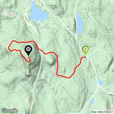
5.8
PDI
4.9 mi
DISTANCE
1,236 ft
GAINED
4.6 %
AVG. GRADE
FULL CLIMB STATS
Page Contributor(s): John Summerson, The Complete Guide to Climbing (By Bike), 2nd Edition; Mitch Reid, Reno, NV, USA
INTRO
This 4.9 mile bike climb is located in MA, USA. The average gradient is 4.6% and there is a total elevation gain of 1,236 ft, finishing at 1,990 ft.
Use the profile tool, route map, and weather forecast to conquer this cycling climb.
Use the profile tool, route map, and weather forecast to conquer this cycling climb.
PLAN YOUR ROUTE
See more details and tools regarding this climb's grade via our interactive Profile Tool.
Information Not Available
If you have any information regarding this climb, we'd like to hear from you. Click the CONTRIBUTE button to share your thoughts with us.
Information Not Available
If you have any information regarding this climb, we'd like to hear from you. Click the CONTRIBUTE button to share your thoughts with us.
Before heading out on any cycling adventure check out our Things to Bring on a Cycling Trip and use our interactive check list to ensure you don't forget anything.
Information Not Available
If you have any information regarding this climb, we'd like to hear from you. Click the CONTRIBUTE button to share your thoughts with us.
ROUTE MAP
MEMBER RATING
CURRENT WEATHER
PJAMM TRIPS ADVENTURE STARTER BUNDLES
Check out PJAMM Adventure's prepackaged (self-guided) cycling trips. They will help you plan, document and conquer your next adventure.
NEARBY CLIMBS (0) RADIAL PROXIMITY
FROM No Climbs Found
MEMBER REVIEWS & COMMENTS
Let us know what you thought of this climb. Signup for our FREE membership to write a review or post a comment.
Already have an account?
LOG IN HERE
robertcarter10058


Nice climb, and at least the best mountain within century-ride range of Boston. There are two descent sections that deflate the avg gradient to 4.6%, but most of the climbing is at about 5-6%, with a few short sections that ramp up to 10-12% as well. The visitor's center with water and bathrooms is nice to park at ($6 per car I think?) if you are driving; you can warm up with a ride down and around the large reservoir and come back to finish with the mountain. The climb is only moderately challenging, but the foothills around the mountain to get to the start point can also get quite steep. There are always a good number of pedestrians and pets to watch out for on the descent down the narrow-ish one-way road back to the visitors center. The road surface on the first half of this route (before the visitor's center) is not the best, but also not the worst.
Mikey62481
So we parked at keys brooks waterfall, then did this route...was great in the fall! The side roads basically have little to no traffic and starts off with a short good incline...So the steepest side road was Pine Hill road. If you do Wachusett Mountain road after Halloween or in the Spring before Memorial Day, it is great because cars are not allowed up the route and its free!