Dead Horse Point Bike Climb - PJAMM Cycling

6.1
PDI
19.4 mi
DISTANCE
1,963 ft
GAINED
1.3 %
AVG. GRADE

FULL CLIMB STATS

Page Contributor(s): Chirs Monson, Blanding, UT, USA; Bruce Hamilton, La Quinta, CA, USA; Stacy Topping, Tacoma, WA, USA.

INTRO

This 19.4 mile bike climb is located in UT, USA. The average gradient is 1.3% and there is a total elevation gain of 1,963 ft, finishing at 6,180 ft.

Use the profile tool, route map, and weather forecast to conquer this cycling climb.

See more details and tools regarding this climb's grade via our interactive Profile Tool.
Information Not Available

If you have any information regarding this climb, we'd like to hear from you. Click the CONTRIBUTE button to share your thoughts with us.

Information Not Available

If you have any information regarding this climb, we'd like to hear from you. Click the CONTRIBUTE button to share your thoughts with us.

Before heading out on any cycling adventure check out our Things to Bring on a Cycling Trip and use our interactive check list to ensure you don't forget anything.
Information Not Available

If you have any information regarding this climb, we'd like to hear from you. Click the CONTRIBUTE button to share your thoughts with us.

ROUTE MAP

MEMBER RATING

Difficulty: Moderate
4
Road
3
Traffic
5
Scenery

CURRENT WEATHER

PJAMM TRIPS ADVENTURE STARTER BUNDLES

Check out PJAMM Adventure's prepackaged (self-guided) cycling trips. They will help you plan, document and conquer your next adventure.
ALL TRIPS
Browse all of our prepackaged trips and find your next adventure!
The American Southwest
United States (AZ,NM,UT)
18 ROUTES
27 POIs
ROUTE STATS (TOTAL)
215.4
mi
DISTANCE
34,866
ft
ELEV. GAIN
Utah: Moab, Arches & Canyonlands
United States (UT)
19 ROUTES
21 POIs
ROUTE STATS (TOTAL)
325.3
mi
DISTANCE
32,871
ft
ELEV. GAIN
Utah: Zion National Park
United States (UT)
20 ROUTES
32 POIs
ROUTE STATS (TOTAL)
256.5
mi
DISTANCE
39,649
ft
ELEV. GAIN

NEARBY CLIMBS (0) RADIAL PROXIMITY

FROM
No Climbs Found

MEMBER REVIEWS & COMMENTS

Let us know what you thought of this climb. Signup for our FREE membership to write a review or post a comment.
Already have an account?

Aug 7, 2023
difficulty: Moderate
scenery: 5
traffic: 4
road: 4
Aug 7, 2023
scenery: 5
traffic: 4
road: 4
Aug 1, 2023 Did this ride from Moab but you can park at Moab Giants at the start on 313 - good food at their Cafe when you get back ! Very moderate climbing all the way up to the dead horse point road. Good roads with very wide shoulders. You have to ride the white line for the 4 miles on the road to the state park but light traffic and slower speed than 313. $10 entry fee if on a bike. $20 by car. The reward is the amazing view at the end. Water only available at the visitor's center / gift shop. FYI : 313 continuing to Canyonlands is in need of repaving- lots of cracks and rough patches. Much better once you pass the entry station. Water available only at the visitor's center - inside faucet is much colder !
May 21, 2021
difficulty: Moderate
scenery: 5
traffic: 2
road: 4
May 21, 2021
scenery: 5
traffic: 2
road: 4
Finished this ride mid-May, 2021. The ride is absolutely gorgeous through Canyonlands and still attractive towards Dead Horse Point. The traffic on the road to Canyonlands is pretty heavy, but it's relatively flat so you'll be going at a good speed. Couple points to note are this full route requires access to both DHP and Canyonlands, so you'll have to pay to enter both, but it is possible to park before the pay station to DHP and bike from there. Also, this route takes you to Upheaval Dome, but the viewpoints from that hike start 1 mile up, so if you want to view the dome you'll need to bring some shoes to wear to hike in.
ROUTE MAP
PROFILE TOOL
Route Data
S.G. (%)
hide
Segment Data
hide
CLIMB SUMMARY

Cycling Dead Horse Point

Although not technically “in” Canyonlands NP, the Dead Horse Point bike climb is just a few miles short of the Canyonlands junction that accesses the 3 main rides in Canyonlands National Park (PJAMM Climb page for 3 climbs in park).  One of 5 national parks in Utah, Canyonlands (official website) is our 30th national park, established in 1964, consisting of 337,598 acres.  This climb is located near Moab and Arches which is another extraordinary cycling venue.  This cycling jewel is relatively little known and not as popular or crowded as some of the other national parks with “just” 739,449 visitors in 2018.  

Average high temperatures exceed 90 degrees during the summer months.  There is little rainfall in this area and the temperatures in May and late September-October are ideal.


usclimatedata.com

Canyonlands is broken into 4 distinct districts by the massive canyons of the Green and Colorado Rivers:  Sky, Needles, Maze and Rivers. Hiking is king in Canyonlands, but you can also experience the beauty of the park on road or mountain bike.  

While Canyonlands does not offer much in the way of challenging bike climbs, we highly recommend riding our route if you are in the area (or even willing to travel to the Moab area to cycle, hike or visit).  

From Moab, head north on Highway 191 for about 10 miles to its junction with Route 313.  

Canyonland - one of five Utah National Parks.

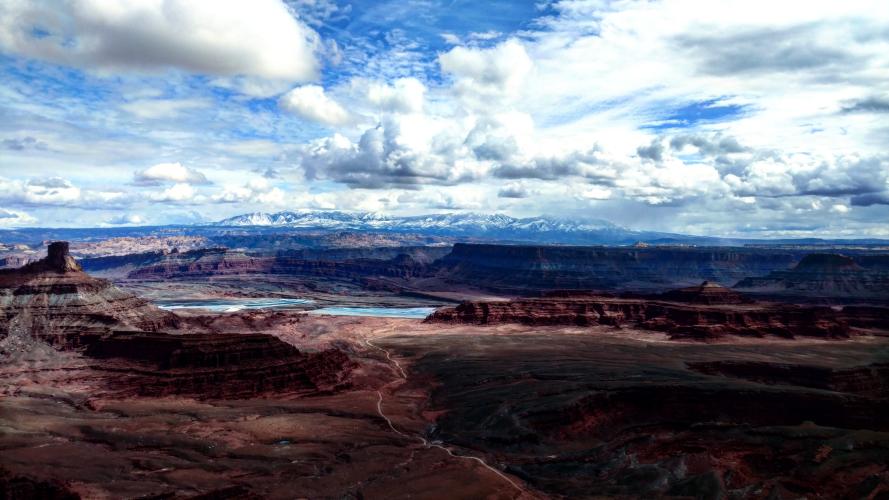
View from Dead Horse Point

Photo:  PJAMM friend and contributor Chris Monson, Blanding, UT

Cycling Canyonlands National Park

Thank you Bruce and Stacy!!