-=![]()
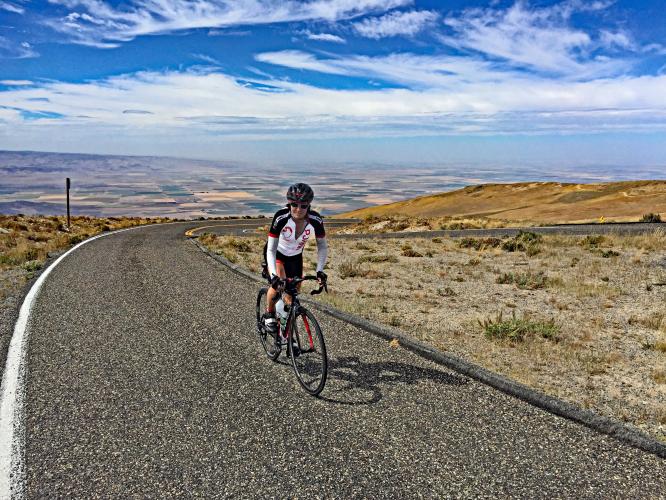
Cycling Mt. Harrison - Idaho’s most difficult bike climb (viewpoint at top)
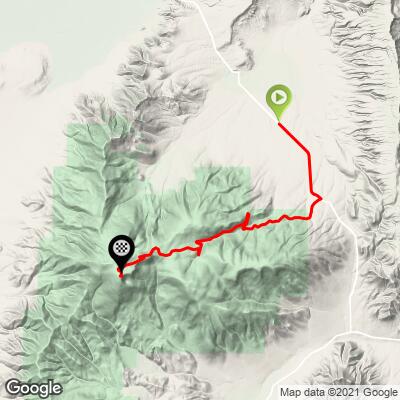
Ride 14.6 miles gaining 4,383’ to elevation 9,238 at 5.6% average grade.
Located in Idaho's Albion Mountain Range, this climb is a bit of an outlier bike climb and is 141 miles northwest of Powder Mountain (US #12)., UT, the closest Top 100 U.S. Climb. The climb is equidistant from Salt Lake City (173 miles) and Boise Idaho (171 miles).
![]()
Ride from Albion 2 miles to the start of the climb.
John Summerson Summary:
“The big climb in Idaho, Mount Harrison is an isolated ascent to altitude in the rugged southern part of the state. After a moderate start the grade gradually increases along Route 77 before you reach a short flat. Turn right here after just under two miles (toward Pomerelle ski area) to continue as this road takes you the rest of the way up the mountain. Here you are met by a stout grade for almost two miles before you encounter a flat and then a short descent. Climbing resumes over fairly shallow grade and soon a few trees appear as you ride through a drainage. From here this pattern is repeated several times as you ascend. There are 2 cattle guards along the way as well. Near the top is one last section of solid grade and just before the very top the trees disappear and you summit at a small parking area with restrooms within an alpine setting. You are greeted by 360 degree views at the summit (top section closed in winter - Sawtooth National Forest - 208 737-3200). Thanks to Idaho climber Chip Keys for this one.” This quote is presented with the approval of John Summerson, from his book, The Complete Guide to Climbing (by Bike), 2nd Edition, pg. 186.)
![]()
At the Lake Cleveland sign, turn off of Hwy 77 onto Howell Canyon Road at mile 3.2.
7.1 miles at 5.5% to Pomerelle Mountain Ski Resort and 11.4 miles gaining 3,646’ at 5.8% to the top.
The climb is in the Sawtooth National Forest (2,110,408 acres, established 1905). As with so many areas of the west and northwest, fire is always a danger during most parts of the year.
![]()
Lake Cleveland comes into view around mile 12.7
There are 2 campgrounds on Lake Cleveland and 2-3 others in the area.
![]()
Information board to your right at mile 4.1
![]()
![]()
Views and scenes along the second half of the climb.
![]()
There are a couple sets of hairpins on the climb.
![]()
Mountain Man map/plaque on your left at mile 12.
![]()
Ron Hawks - nearing the top September 27, 2017.
![]()
View and info board at the top.
![]()
Views at and leading to the top.
Photo upper right is the top of the climb.
This excellent summary from PJAMM contributor Rick Greenawald, Twin Falls, Idaho:
The Mt. Harrison climb is a challenging one starting out of Albion, Idaho. It is the course for the now defunct Mt. Harrison Hill Climb Race. The route is punctuated by open roads with little traffic, very little shade and with the summer sun and high temperatures experienced in southern Idaho, it is best to get a start on the climb by mid to late morning. It should be noted that the road to the top is often not open until late June or early July due to the large snow pack received during winter. Pomerelle Mountain Resort is located at mile 10.2 of the route (8,000' and 12 miles from Albion). The only opportunity to stop for water along the way is at the Pomerelle lodge, if it happens to be open (unlikely during the non-ski season). Be prepared and bring all of your hydration and nutrition needs with you from the start. Road surfaces are chip seal, a little heavy for the most part here in southern Idaho, but are also in good condition. The pavement is generally "heavy", but you will not have to worry much about dodging potholes or broken pavement.
Leaving Albion on Hwy 77 the road rises gently to the south past ranches and desert sagebrush; it can be a bit breezy at times, as south central Idaho is notorious for its winds. As you continue south the grade increases as you climb toward the turnoff to Pomerelle and the summit. A right hand turn off of the highway (mile 3.2) and the climb really starts in earnest. This climb is basically a grind from this point on. There are only a couple of places where the grade eases to any appreciable degree. After turning off Hwy 77 onto Howell Canyon Road, there are some nice views to the north across the valley toward Albion, but you will most likely be concentrating on the task ahead. The road follows a ridge to the south of Howell Canyon and you'll encounter at least one cattle guard shortly after making the turn. The first part of this portion of the climb is completely exposed with no shade to speak of. There are a number of curves and turns on these lower stretches, but no switchbacks and sightlines are good.
As you continue to climb you eventually enter a stand of trees that offer a little shade, but the road will not offer you any respite. As you come to the end of this stand of trees you will encounter the first switchback along the route, taking you across Howell Creek and to the north side of the canyon. At this point we have a view to the east and the road of which you have already dispatched. You are also greeted by views of the Cotterel Mountains to the east of the valley. The climb makes its way to the northeast before turning back southwest and then west a short time later. There is a nice view to the north at the second (of three) switchback at ~mile 10, looking northeast toward Albion. The entrance to Pomerelle Mountain Resort is at the bend in switchback 2 at the 10 miles mark (still 4.3 miles, 1,540' at 6.6% to go!). When the climb again turns west you are in for a long, pretty much straight, stretch of road along a ridge line. Below you, to the south, is forest, but you are not afforded any shade on this section as any trees are upslope to your north.
After big switchback 2 the road again turns upward and becomes even more challenging. The climb continues through stands of trees, but only for a mile or so before you exit to a more rugged alpine setting with few trees and plenty of barren rock and scrub brush with some alpine flowers to be seen. It is here that you start to get exposed to the potential for plenty of wind from nearly any direction. Passing the turnoff to Lake Cleveland we now have 2.1 miles 815' at 7.1% to go (elevation 8,400 to 9,200'). Beware of the temperature drop at the higher elevation and that you may encounter snow remaining on or near the road early in the “road open” season. I have had to dismount and walk through a few sections early in the season on a few occasions.
Finally it is on to the last push across barren terrain as you continue the climb to the summit. With roughly a mile to go you can see the fire lookout at the summit which, mirage-style, can appear to distance itself from you as you struggle to reach it - the air is thin at 9,000'! (27% less than at sea level). There is one last nasty little pitch to the lookout parking lot and you have achieved your goal of climbing Mt. Harrison and the highest paved road in the state of Idaho. The summit can be quite breezy and cold in the middle of summer, so bring a vest or light jacket with you for the top and also for the first part of your descent back down the road. The road is a dead end at the top, so you’ll be descending the road you just climbed. At the summit you can look out across southern Idaho’s Magic Valley on a clear day. To the north you will see the city of Burley; to the west-northwest you can spy the city of Twin Falls. The irrigated farm fields stretch out for miles and miles. To the south you can see the 10,000+ foot Cache Peak, part of the same mountain chain that includes Mt. Harrison. There are interpretive signs at the summit too, detailing fauna and flora and the crash site of a World War II era bomber.
As you prepare to descend be aware that the winds can play a little havoc on the first three miles of the descent and you’ll probably want to put the vest or jacket on. Also be aware that all along the route, once you turn off of Hwy 77, it is open grazing land. It is not uncommon to come across cattle along or on the road. You may also encounter a moose or elk along the way, so descend with some caution. Once you are back down around the Pomerelle resort you can usually shed the vest and be just fine for the rest of the descent. You might want to make a stop at Lake Cleveland on your descent. The road down to it is paved and it is a beautiful little alpine lake. However, you do have to climb back out, a short distance (half mile and 100'), to begin the rest of your descent back to Albion.
I highly recommend this challenging climb. Wind conditions can make this a very tough climb at times. The window for doing the complete climb is also not the longest. In general, expect to be able to do the full climb during July, August and September. Prior to, or after, that time period you may find the gates closed to the top three miles due to snow."
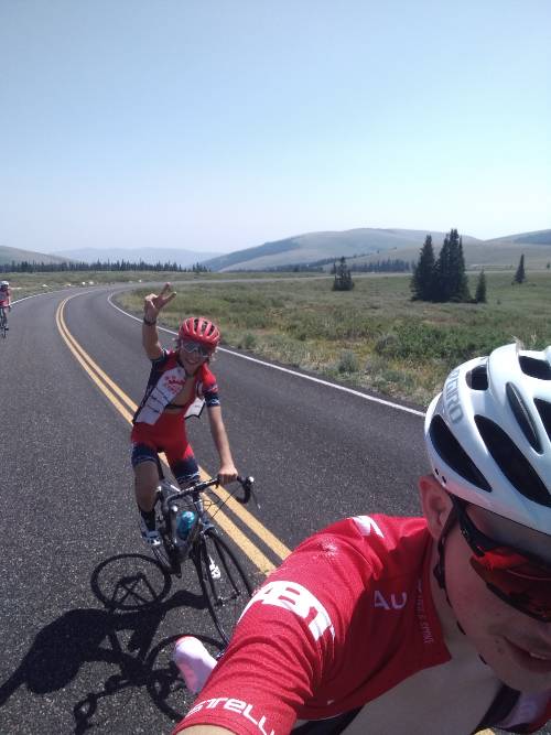
Thanks also to Rick for the excellent summit photos shown above!
Thanks also to another great PJAMM contributor, Arthur Tyczka (Boise, ID), for his contribution (including excellent photos for the slideshow):
I don’t race my bike, I ride for pleasure, fitness and its therapeutic effects. Mt. Harrison is doable for the recreational rider. Funny story, I was at the top, walking around the overlook and another cyclist rides up, the only other cyclist I saw that day, and he mentions that he was riding tempo up it and I couldn't help but laugh, it took me considerable effort and he didn't look at all winded. For me, it was a bit of a grind, but most climbs are for me, if I was in a running event I would be considered a Clydesdale.
Back to the ride, I thoroughly enjoyed this climb. The gradient is never too difficult which permits you to get into a good rhythm. The views are amazing, especially at the top. I rode in early July and the temperature was quite comfortable - and as you ascend, you get some nice cool breezes that blow from the top of the mountain.
Traffic was a non-issue. The road to the top was in great condition. I started my ride at the intersection of 77 and Howell Canyon road, which is the road to the top, and there’s a pull out right in front of the Pomerelle sign where you can park and begin your ride. You can ride on 77, however, the shoulder is narrow to non-existent and the speed limit I believe is 55. I felt comfortable beginning where I did. What I enjoyed the most from this ride is the solitude, at times I felt I was the only person on the mountain and of course your efforts are rewarded by the magnificent views from the top.
I would definitely recommend this ride to all in the area or willing to travel for exceptional climbing experiences - It’s a little out of the way, however, to tie it into a great weekend, the City of Rocks National Reserve is only 40 minutes south of Mt. Harrison. If you’re into rock climbing, which I’m not but it was neat watching them, there’s excellent places to rock climb and hike. You can grab a camping spot at the City of Rocks, spend a day or two there and do some exploring and ride up Mt Harrison as well. Be warned, if you do plan to camp at the City of Rocks, you'll need to reserve a camping spot well in advance as it's a popular destination.