Mt. Mitchell Bike Climb - PJAMM Cycling

7.3
FIETS
24.4 mi
DISTANCE
6,064 ft
GAINED
4 %
AVG. GRADE

FULL CLIMB STATS

Page Contributor(s): Ron Hawks, Las Vegas, Nevada, USA; Amy Subar; Shanda Proulx, Catawba, SC.

INTRO

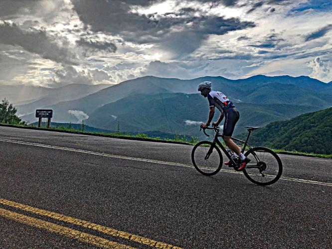
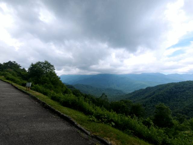
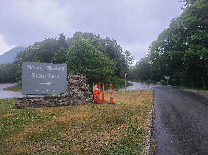
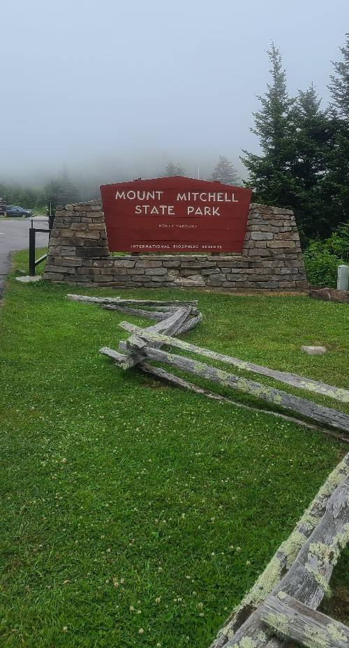
This is the hardest, highest, and most popular bike climb in North Carolina. Much of this climb is on the incomparable Blue Ridge Parkway, featuring eight of its highly regarded and scenic overlooks. The bike climb ends in a parking lot at 6,578'. Hike 100 yards from the parking lot to the Mt. Mitchell Observation Tower that sits at 6,684' - you cannot stand anywhere higher in North Carolina or in the entire Appalachian Mountains.

Our PJAMM Cycling Adventure App's preloaded Blue Ridge Parkway and Smoky Mountain National Park self-guided tours are accessed below. 
Mt. Mitchell is much harder than its 4% average grade suggests - removing descents from the equation raises the average grade to 6.2% (15% of the climb includes some descent); 31% (7.6 miles) is at 0-5% grade, 52% (12.6 miles)  5-10%, and a fraction is 15-20%.  The steepest quarter mile on the climb is 11.2% and the steepest mile 8.1%.  98% of the climb is under 10%. 

See more details and tools regarding this climb's grade via the “Profile Tool” button.
Roadway:  The roadway was in good shape as of 2020.

Traffic:  The first seven miles on Highway 80 before the hairpins just before turning onto the Blue Ridge Parkway are a bit dicey because of the moderate flow of traffic along a roadway with minimal shoulder.  Once we begin climbing the hairpins on through our stretch on the BRP and final segment on Scenic Route 128 to the summit, traffic reduces and the climb is more pleasant. 

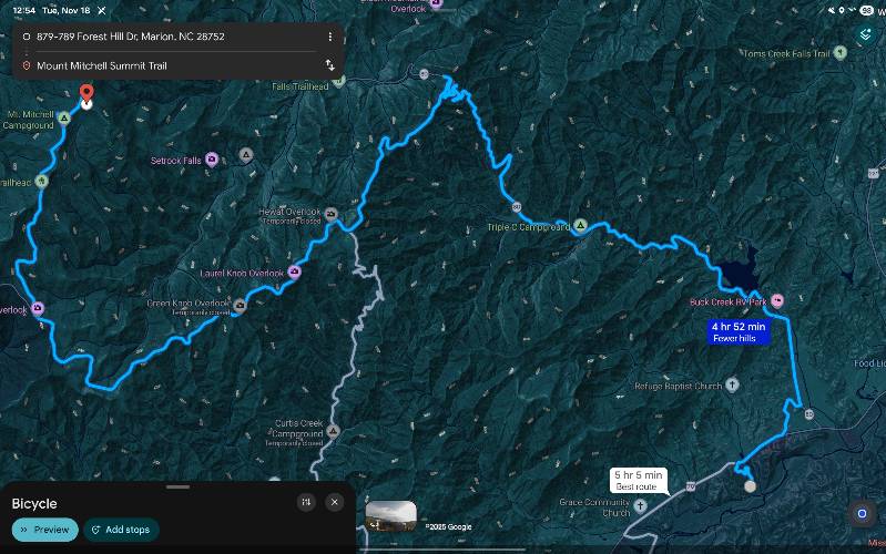
Parking:  It is very hard to find parking anywhere near the start.  The best place to park is at the abandoned hotel parking lot at the intersection of Highways 70 and 80, 3.8 miles from the start of the climb (Map; Street View). 
Provisions:  The only location for food and beverages on this ride is at Mount Mitchell Stat Park Restaurant at mile 22.7 (1.7 miles from the top) - Street ViewGoogle Map + Reviews (reservations/questions:  828-675-1888) 

Weather and clothing:   We finish 5,000' above where we begin so it will be colder at the finish than the start, depending upon the time of day.  Consult the PJAMM summit weather forecast to assess your clothing needs at the climb's finish.  You can also get weather conditions from the State Park Website.

Cycle the entire Blue Ridge Parkway – see PJAMM’s March 2022, 467-mile adventure on the PJAMM Adventures App: Blue Ridge Parkway
Before heading out on any cycling adventure check out our Things to Bring on a Cycling Trip and use our interactive check list to ensure you don't forget anything.
Hotels at Mt. Mitchell
Booking your travels through one of these links helps us continue to bring you awesome info on climbing and cycling. Thank you! 

Things to Do:  Visit the museum at the park offices and restaurant at mile 22.7 (Street View).   Also hike 300 yards to the highest point in North Carolina from the parking lot at the finish (Map).  Be sure to stop on the way up or way down and enjoy the magnificent views at the many viewpoints along the ride - see our Full Summary section and also Images on the profile map for more details.

Also, consider other climbs on the Blue Ridge Parkway via PJAMM's  “Routes in Area” button on the menu bar above, or Blue Ridge Parkway (NC to VA), or Blue Ridge Parkway from the north - entire route. 
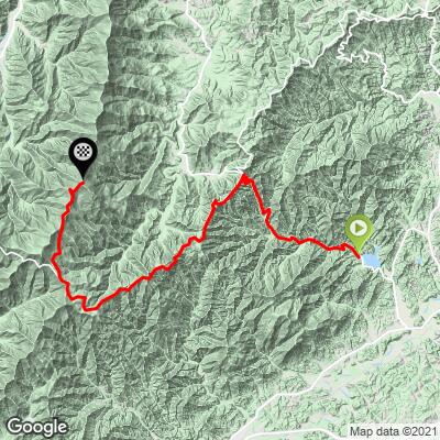
ROUTE MAP

MEMBER RATING

Difficulty: Challenging
3.8
Road
3.8
Traffic
4.4
Scenery

CURRENT WEATHER

PJAMM TRIPS ADVENTURE STARTER BUNDLES

Check out PJAMM Adventure's prepackaged (self-guided) cycling trips. They will help you plan, document and conquer your next adventure.
ALL TRIPS
Browse all of our prepackaged trips and find your next adventure!
Smoky Mountain National Park
United States (NC,TN)
17 ROUTES
31 POIs
ROUTE STATS (TOTAL)
181.8
mi
DISTANCE
34,253
ft
ELEV. GAIN
The Blue Ridge Parkway (North)
United States (NC,TN,VA)
38 ROUTES
70 POIs
ROUTE STATS (TOTAL)
716.5
mi
DISTANCE
75,697
ft
ELEV. GAIN
The Blue Ridge Parkway (South)
United States (NC,TN,VA)
30 ROUTES
63 POIs
ROUTE STATS (TOTAL)
690.7
mi
DISTANCE
74,180
ft
ELEV. GAIN

NEARBY CLIMBS (0) RADIAL PROXIMITY

FROM
No Climbs Found

MEMBER REVIEWS & COMMENTS

Let us know what you thought of this climb. Signup for our FREE membership to write a review or post a comment.
Already have an account?

Jul 13, 2023
difficulty: Moderate
scenery: 4
traffic: 4
road: 4
Jul 13, 2023
scenery: 4
traffic: 4
road: 4
June 18, 2023 I rated this climb moderate because I only did the Mt Mitchell part. Parked at the bottom of the road on a pull-out on the BRP. There was a Sunday race-car rally and motorcycle rally all zooming up and down the BRP. Too many Fast & Furious wannabes to my liking. Although a much shorter climb, it's still a nice moderate climb with good views, a good road, light traffic, and a fun, safe, no-brakes decent.
Jul 7, 2023
difficulty: Challenging
scenery: 4
traffic: 5
road: 3
Jul 7, 2023
scenery: 4
traffic: 5
road: 3
Re-rode this guy on Independence Day 2023. Minimal traffic going up (early) and lots of traffic on the descent (going the opposite direction). The NPS portion of the road has improved noticeably since last year. Several other early riser cyclists making the grade. Great climb on a great day.
Jul 8, 2022
difficulty: Challenging
scenery: 5
traffic: 4
road: 3
Jul 8, 2022
scenery: 5
traffic: 4
road: 3
An early start was imperative as it was a roaster of a day once I returned back to my car. I grabbed the parking spot at the lake/Little Buck intersection. Great pavement and some classic Appalachian climbing up to the Parkway. The chip sealed BLRI soon turns to smoother pavement. Beautiful and short tunnels, incredible views, and minimal traffic in the early morning added up to a great experience leading up to the top. The NPS’s staffing/funding woes are evident with the graffitied overlook signs and the poor conditioned road. Mt Mitchell state park looks to have its own woes as well with multiple portOpotties outside the visitor center. The top was completely fogged in but lower elevation views were incredible. The return trip’s final 8 miles are sporty with switchbacks and some nice stretches to let off the brakes, An amazing day in the saddle.
Apr 18, 2022
Another start point is the folk art center off the blue ridge parkway in Asheville. Plenty of parking. About 32 miles and 5,600 ft too the top, along with 1400 ft of decsent (the worst is having to climb 1400 on the way back) Good ride
Mar 24, 2022
difficulty: Strenuous
scenery: 5
traffic: 3
road: 4
Mar 24, 2022
scenery: 5
traffic: 3
road: 4
After seeing this climb on this site a couple of weeks ago I decided to do it....So, I drove from St Louis yesterday and did the climb today. It's an awesome ride, with great views and I would highly recommend it. Where I cycle normally we have steeper hills (lots of 10%-15% grades) but those climbs are a 1/4 mile up to a mile...this was a new experience...I started at highway 70 and 80 which I would recommend...it's 29 miles and about 6,300 feet to the summit from there. Here's my router if anyone is interested...Oh yeah, right near that intersection is a business, Outdoor Building and Yard Solutions...Very nice people there, Tom and Kara....I asked them if I could park there during my ride and they said no problem...Tom used to be a cyclist before back surgery took him out of it...Since parking can be an issue this was a real plus.
Sep 26, 2021
Fantastic ride! I thought it wasn't that bad, considering this was my first big climb. I train year round so I'm usually in pretty good shape. Made it up in ~2.5hrs. The last few miles up to the summit is challenging, but completely doable.
May 24, 2021
difficulty: Strenuous
scenery: 5
traffic: 3
road: 4
May 24, 2021
scenery: 5
traffic: 3
road: 4
I did the climb on 5/22/21, and it was spectacular. The first segment was a fun windy road, the second segment was on the Blue Ridge Parkway which was the most scenic part of the ride with all of the overlooks. The last segment to the top was tough, but not too much. The view from the summit was a fitting reward for the effort. It was pretty hot when I went, I probably should've started earlier in the morning to avoid the afternoon heat at the lower elevations. There is a decent amount of shade available on the route,especially the lower elevations, that helped a lot. The road of the Blue Ridge Parkway was in good condition which was particularly helpful on the descent. The lack of shoulder on the road was not a big deal because cars were not going to fast and give you space. This is certainly worthy of it's top 10 scenic climbs ranking. Definitely do it if you have the opportunity.
Mar 9, 2021
difficulty: Strenuous
scenery: 4
traffic: 4
road: 4
Mar 9, 2021
scenery: 4
traffic: 4
road: 4
Have done this climb in March and in late May. Much better scenery in late May but a lot more people and traffic also. Great switchbacks early on and just enough descent midway through to get the legs back under you. Make sure to take bike the final way up the sidewalk at the summit for the photo op.
ROUTE MAP
PROFILE TOOL
Route Data
S.G. (%)
hide
Segment Data
hide

Climb Profile Not Found
CLIMB SUMMARY

Climbing Mt. Mitchell by bike - bicycle with PJAMM cycling jersey draped over it, elevation sign 6,578 feet, sunrise on mountainside with pine trees

Cycling Mt. Mitchell -- a bike climb in North Carolina’s Blue Ridge Mountains

Ride 24 miles to elevation 6,684’, gaining 6,409’ at 4% average grade. 

Climb summary by PJAMM’s John Johnson.

Climbing Mt. Mitchell by bike - photo collage, Mt. Mitchell elevation sign with bicycle leaning against it, Blue Ridge Mountains, sign for Mt. Mitchell State Park, cyclist riding on road, lush green forest,  Blue Ridge Parkway US Forestry Service sign, sign for Highway 128, NC Scenic Byway, misty road with pine trees, cyclist riding next to Scenic Byway End sign

Mt. Mitchell is both extremely scenic (it is a Top 10 US Scenic Bike Climb) and very difficult.  While the average grade is 4%, this is misleading due to two brief and one significant (2.1 miles at 5%) descents along the 24 mile climb.  The overall average for the climb, excluding descents, is 5.7%.  While 5.7% is a good climb for 20+ miles, this climb is much harder than the 5.7% average implies -- there are several one-half to one mile segments that average over 8% -- the steepest quarter-mile is 11.2% and steepest mile is 8.1%.

Climbing Mt. Mitchell by bike - photo collage, road with share the road sign, and notice of steep winding roads sign, bicycle on bridge, lush greenery reflecting into water

Left Photo: Just past the junction of Routes 70 and 80, five miles from the climb.

Right Photo: Climb begins at the western edge of Lake Tahoma on Route 80.

Note there is very little parking at and near the start of the climb.  The best place to park for the climb is near the junction of Routes 70 and 80.  Thanks to Amy Subar for this detail.

Parking at the T of Routes 70-80 and just up Route 80 on the left.

Mt. Mitchell is a long climb with many switchbacks that begins on Highway 80, west of Lake Tahoma.  At mile 8.4 take a hard left onto the Blue Ridge Parkway, which is known for its beauty and length, running 469 miles through 29 counties in Virginia and North Carolina, connecting Shenandoah and Great Smoky Mountains National Parks.  Shenandoah National Park (est. December 26, 1935; 200,000 acres), is located just 75 miles from Washington, D.C., but seems like a world away.  

PJAMM APP - Start of climb

Things to see within Shenandoah NP include “cascading waterfalls, spectacular vistas, fields of wildflowers, and quiet wooded hollows” and it’s lands are a “haven to deer, songbirds, and blackbear.”  If you’re planning on exploring throughout Shenandoah NP, visit the US National Park’s services webpage for the park, here.  Great Smoky Mountains National Park is actually the nation’s most visited national park (with 11,421,200 visitors in 2018).  On a visit to GSMNP, one can expected to be dazzled by the park’s “diversity of plant and animal life, the beauty of its ancient mountains, and the quality of its remnants of Southern Appalachian mountain culture”.  This gorgeous National Park exists on the border between North Carolina and Tennessee and is certainly a gorgeous place to visit.  For more information on planning your trip, you can visit the National Park’s services webpage for Great Smoky Mountains, here.

Climbing Mt. Mitchell by bike - photo collage, Mt. Mitchell State Park sign at sunset, pine trees with setting sun shining through, pink blossoms along roadside with cyclist and green foliage, mountainside covered in lush greenery, large barren tree on mountainside with green pastureland around it, Curtis Valley Overlook sign with PJAMM cycling jersey draped over bike, lush forestland with bicycle leaning against tree

The bike climb to Mt. Mitchell runs through thick forest from start to finish.  We end our climb at the Mt. Mitchell Summit Trail in Mount Mitchell State Park (est. 1915; 1,966 acres) and here we are a stone’s throw form Pisgah National Forest (est. 1916; 512,758 acres). This wonderous bicycling adventure is located within the famous Blue Ridge Mountains, which run 550 miles southwest from southern Pennsylvania through Maryland, West Virginia, Virginia, North Carolina, South Carolina, Tennessee, Georgia, and Alabama.  The Blue Ridge Mountains are a portion of the Appalachian Mountain Range, which stretches from Georgia and Alabama all the way into Canada.

Climbing Mt. Mitchell by bike - photo collage, dense green forest land, road surrounded by greenery, bicycle leaning against low grey retaining wall, road sign saying Bridge Ices Before Road

First third of the climb.

Word of Caution:  The first 8 miles on State Route 80 is along a windy road with minimal to no shoulder.  There are sharp (blind to nearly blind) curves along this segment.  Therefore, we recommend you wear fluorescent clothing and/or use a rear light for the first segment.

Climbing Mt. Mitchell by bike - Sunnyvale Baptist church sign, traditional white church building, bike on church's front porch

Sunnyvale Baptist Church at mile 3.3 -- at the bridge over Buck Creek.

Climbing Mt. Michell by bike - cyclist standing on bike while climbing, road, Blue Ridge Mountains in background

Big Laurel Gap Overlook - mile 12.6.

Miles 8.4 to 19.4 are along the gorgeous Blue Ridge Parkway.  It is along this stretch that we have the benefit of several of the Parkway’s scenic overlooks.

Climbing Mt. Mitchell by bike - photo collage, dense tree-lined road, bicycle leaning against grey retaining wall, bicycle leaning against Easter Continental Divide road sign

Middle section of the climb.

Cycling Mt. Mitchell by bike - photo collage, stone tunnel, road, road sign for tunnel, ferns and foliage

There are a couple sets of short tunnels in the middle section of the climb.

Climbing Mt. Mitchell - arial drone view of cyclist climbing into tunnel

Climbing Mt. Mitchell by bike - photo collage, Mt. Mitchell State Park sign, bike leaning against sign, foliage lined road with Visitor sign

Turn off of Blue Ridge Parkway onto Highway 128 at mile 19.7.

As of 2020, there is no fee to enter the park on bike or in a vehicle.

Park office at mile 22.8

“Mount Mitchell has one of the greatest elevation gains of any climb in the United States and contains many different types of climbing sections along its route.  The first section (Route 80) is a very narrow road.  It starts out over shallow grade but gradually gets steeper as you ride between small mountain homes in places.  Eventually signs of civilization disappear and you find yourself in thick woods.  Toward the top of this section you encounter several switchbacks as you near the Blue Ridge Parkway, one of which contains the maximum grade on the hill.  Turn left on the Parkway to find more moderate grade and soon travel through two short tunnels.  Just beyond the 2nd tunnel you will find a descent.  Climbing soon resumes over solid grade and you will find good views in places.  After a mile long descent, resume moderate grade climbing which then gets more shallow.  After almost 20 total miles turn right on Mount Mitchell State Park Road.  This final section is a bit steeper overall and the road dead ends near the top of Mount Mitchell as the highest legal paved road in the eastern U.S.  this is a long hill so make sure you go prepared.” (This quote is presented with the approval of John Summerson, from his book, The Complete Guide to Climbing (by Bike), 2nd Edition, pg. 110.)

FINISH

Climbing Mt. Mitchell by bike - grey sky at climb's finish, cyclist pulling into end of climb

Bike climb finishes at the parking lot at 6,578’.

Walk another 300’ to the highest point in the Appalachian Mountains and North Carolina.

There are many running and hiking trails in Mount Mitchell State Park.

Climbing Mt. Mitchell by bike - placard at climb's finish for North Carolina Civilian Conservation Corps

Climbing Mt. Mitchell by bike - placard for Mount Mitchell State Park, Registered Natural Landmark

OBSERVATION TOWER

Observation platform and the Mount Mitchell high point, a 300’ hike up from bike climb finish.

There is a plaque showing peaks in the distance from every compass direction on the tower.

Before heading out on your Mt. Mitchell cycling adventure, be sure to rely on our list of Things to Bring on a Cycling Trip, and use our interactive checklist to ensure you don't forget anything.

MT. MITCHELL IN THE FALL

Climbing Mt. Mitchell by bike - cyclist on road surrounded by trees

The Assault on Mt. Mitchell ride is a 102.7 mile, 10,000’ annual century ride that ends at the Mt. Mitchell finish (Stava Map).

“The 44th Annual Assaults presented by Greenville Health System will be held on Monday, May 20, 2019. The Assaults is one of the most intense, premier cycling experiences that draws a full field of nearly 1,000 cyclists from across the world each year. This one-day challenge takes riders from Spartanburg, SC to the top of the highest peak in the East, Mt. Mitchell. Please join us for the 44th Annual Assaults on Mt. Mitchell and Marion in 2019” (The Assaults).

Image:  theassaults.com.

Transportation options:  Summary by Shanda Proulx, Catawba, SC.

THE OVERLOOKS

There are seven official overlooks along the climb to the top of Mt. Mitchell, in addition to the multiple locations you can pull over on your bike and enjoy the magnificent view of the Blue Ridge Mountains.  The overlooks begin with Singecat Ridge Overlook (3,406’) at mile 9.7 and end with Ridge Junction Overlook (5,160’) at mile 19.7.  Each overlook has a space for at least several vehicles, and a couple are full parking lots. The views from the overlooks on a clear day are simply extraordinary and we do recommend stopping at each to enjoy the scenery.

Note:  You can view our photos of each overlook on our in the Virtual Ride section of this climb page by clicking on the blue “Images” button just above the gradient profile.

SINGECAT RIDGE OVERLOOK

Climbing Mt. Mitchell by bike - Singecat Ridge Overlook sign, bike leaning against sign, Blue Ridge Mountains

Mile 9.7 / 3,406’.

BIG LAUREL GAP OVERLOOK

Climbing Mt. Mitchell by bike - Big Laurel Gap Overlook sign

12.3 miles / 4,175’.

This is also referred to on some maps as Hewat Overlook, but the sign clearly calls the Overlook Big Laurel Gap.

CURTIS VALLEY OVERLOOK

Climbing Mt. Mitchell by bike - Curtis Valley Overlook sign

Mile 13.1 / 4,460’.

LAUREL KNOB OVERLOOK

Climbing Mt. Mitchell by bike - U.S. Forest Service informational sign, pine trees, Blue Ridge Mountains

Mile 13.6 / 4,606’.

Climbing Mt. Mitchell by bike - photo collage, Iconic Tree at BiG Laurel Gap Overlook

Iconic Tree at the overlook.

This overlook is not to be confused with Big Laurel Gap Overlook which is 1.3 miles earlier in the ride at mile 12.3.

MT. MITCHELL OVERLOOK

Climbing Mt. Mitchell by bike - View Mt. Mitchell Sign

Mile 14.3 / 4,825’.

GREEN KNOB OVERLOOK

Climbing Mt. Mitchell by bike - Green Knob Overlook sign

Mile 14.8 / 4,760’.

RIDGE JUNCTION OVERLOOK

Climbing Mt. Mitchell by bike - Ridge Junction Overlook sign

Mile 19.7 / 5,160’.

That’s a wrap!

No, wait - we received in September, 2020 a wonderful ride report from the extraordinary Amy Subar, (she doesn’t just swim, ride, run . .  )

Top of the podium - 2015 ITU World Triathlon Grand Final

Amy’s summary of her ride up Mt. Mitchell:

On September 4, 2020 my husband and I started what we thought would be an epic ride up Mt. Mitchell, the highest point in the eastern US, which is located off the Blue Ridge Parkway. in North Carolina. It was this website that got me interested in doing it.  (I say, "me," because, before we came, my husband was quite adamant that he was NOT interested in doing this particular ride with me!):

It was a ride with echoes of other climbs we have done, such as Skyline Drive in Shenandoah National Park starting at Front Royal, however, the climbing was much more constant.  It was more similar to Trailridge Rd in CO, but without the high altitude. In the 28 miles out, there were only 2.5 miles of descent (and let me say, those same miles of climbing on the way back were NOT welcome!) (Note: This website indicates that the climb is 24 miles but we could find no place to park at the starting point indicated (Lake Tahoma) so we had to park farther away. (at the intersection of Rt 80 and Rt 70)  This added 4 more miles and a bit more climbing.)

First, let me say that the ride was beautiful, start to finish, especially along the Blue Ridge Parkway.  There were spectacular mountain ridge vistas to enjoy while climbing.  But as I said above, the climbing on this route basically never stops.  That's tough, right?  Although the website says that the average grade is 4%, there are many, many sections of 8-11% grades that made 4% seem easy.  So, it's the relentlessness of it that gets you.  My goal was to make it to the top, so, from the start, I just took it slow and easy.  I sat in my saddle and cranked in easy gears.  By the middle of the ride, that wasn't even a choice!  I was nearly always in one of the easiest 3 gears.  I also was trying to enjoy the ride, so I stopped a lot to take pictures and wait for my husband.  

Oh, so, yeah, my husband who was NOT going to do the ride, decided to come with me that morning with no commitment to ride to the top.  He had not been riding that much due to a bad back, but he was feeling better so he came even though his legs were fatigued from our 3 previous days of hiking and cycling in the area.  He soldiered on and made it to around 3/4 of the way to the top but was clearly NOT HAVING FUN by then.  He told me to go on to the top without him, which, at that point, was still 7 tough miles away.  We planned to meet at one of the lookouts on the way down.  So, I was off to finish the climb by myself.  The distance up to the turn off of the Blue Ridge to Mt. Mitchell was more of the same but I was now getting pretty tired. I was also so close!  After the turn, with a little more than 4 miles to the top, the first few miles came in at a gradient of 8-11%.  This made me question whether I was going to make the final 2 miles to the top.  It was windy and lonely (except for the cars passing me) -- I wished I had one of my cycling buddies with me!  Thankfully, after those few miles, the gradient leveled a bit, and I had one truly easy mile for which I was incredibly grateful.  But, no way was that to continue to the top.  The last mile cranked up again to 8-9%.  

So, you know the end of the story -- I made it to the top (yay!) where there was a jarring change of scenery and ambience:  Gift shop, viewpoints, and crowds (though this was during the covid pandemic).  Everyone else there had driven up, like on Mt. Washington in NH.  I received many comments and enthusiasm from friendly folks who had seen me climbing up. There was a wedding up there and tourists, most wearing masks, taking in the spectacular views.  I had climbed over 5,000 ft in 28 miles with 1,000 of them in the last 4 miles. My average speed up to that point was 9 mph. I had eaten a gel with caffeine around halfway up, and intended to eat a bar at the top, but when I reached in my pocket for it, I didn't have it!  Forgotten!  Bummer. At least the climbing was over.  I'd just have to hope my husband had extra food.  

I was SO looking forward to the descent!  I checked my texts to see where my husband would be waiting for me on the way down.  Fortunately, I had a jacket with me.  It was windy and chilly at the top with some cloud cover.  I'm a person who gets cold easily, so I was happy to have the jacket to put on.  The initial 4+ mile descent down the Mt. Mitchell road to the Blue Ridge Parkway was not that much fun for me -- cold, windy, etc.  My fingers were numb by the time I got to the Parkway. At that point, there was only more descending to do even though it was warmer.   It wasn't until slogging up the 2 mile ascent (which came quickly) that I felt my fingers again even though the temperature was in the mid-70's.  I soon met up with my husband, ate some of his energy bar, and we made our way down to the bottom.  It was super fun and fast!

I hope that you have the opportunity to do this ride in the future or any ride on the Blue Ridge Parkway.  The views were spectacular.  I am eternally grateful that I am still able to do this kind of ride at the age of 64.  

Access to full Climb Summary requires a PJAMM Cycling PRO Membership!

It takes less than a minute to sign up & with your PRO membership you can:
  • Rate climbs, post comments and share your experiences on any of our climb pages
  • Create bucket lists of climbs & mark the dates you complete them
  • Weather data for all climbs - Start & Finish
  • Upload photos to your member page to customize your PJAMM Cycling experience
  • Utilize all of our interactive tools - Profile & Routes in Area
  • Download climb route .gpx files
LEARN MORE
SIGN UP

Already have an account? LOG IN HERE