![]()
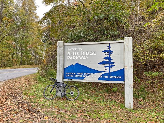
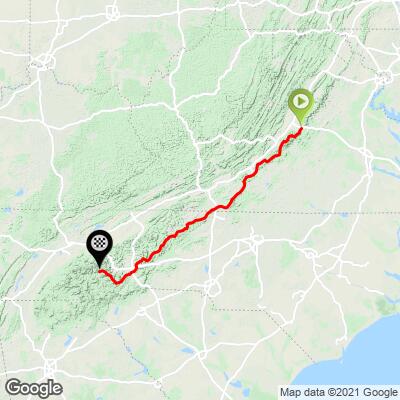
The Blue Ridge Parkway (BRP) is a beautiful route to cycle. The BRP begins at the end of Skyline Drive-Shenandoah NP in Afton, VA and ends in the Great Smoky Mountains National Park in Cherokee, NC. Although it is not typical for cyclists to ride the entire route we have listed on this page all of the CAT 4 and above climbs on the route and those which end at the BRP.
![]()
Thanks much to our dear friends Carla and Tom Morton for many of the photos on this page.
If you are interested in cycling the BRP you can review PJAMM’s BRP Adventure - Cherokee North Carolina to Waynesboro, Virginia (with Clingmans Dome bonus ride) here: PJAMM Blue Ridge Parkway North Carolina - Virginia together with our Blue Ridge Parkway South-North Route. We did the ride from south to north in March, 2022 when much of the road was closed, the weather was spotty and the road all ours for much of the trip - it was truly EPIC!!
Special PJAMM summary by John Summerson (The Ultimate Guide to Climbing (by Bike) 2nd Ed. + many more US climbing books), the authority on climbing by bike in the United States:
“It has been called the ultimate bicycling road and there may not be a route more ideal for two-wheel riding. The Blue Ridge Parkway carries you through a large portion of the Blue Ridge and Appalachian Mountains, from Afton in northern Virginia to Cherokee in southwest North Carolina. A cycling environment with mostly smooth pavement without commercial vehicles and through scenic, mountain landscapes sounds like a dream.
However, be careful what you wish for as the way is certainly not easy. At 469 miles, cycling its full length is essentially equivalent to riding four major tour big mountain stages over consecutive days. The route is almost constantly either uphill or down and you will work to get through it. It is also a fairly narrow, two lane road so keep this in mind if you set out to ride all of it or just a portion.
At such a long distance, many other roads intersect its length. As the Parkway is also located at altitude (for the eastern seaboard), either on top of or high on the ridgeline, most of these lanes have to climb significant amounts to reach it. Of course, this creates just what climbers desire, a steady supply of challenging ascents along the way.”
![]()
Tom and Carla rode the BRP in September, 2022.
A little bit about the Blue Ridge Parkway:
- 469 miles
- Gain 52,612’ on the ride.
- High point - 6,047’ at Richland Balsam Overlook (mile 433)
- Low point - 649’ at the James River (mile 70)
- Longest sustained climb is 19.7 miles at 3.5% from Asheville at mile 85 and ending just past the Craggy Gardens Visitor center at approximately mile 105.
- 15 visitor centers.
- Over 200 viewpoints/overlooks;
- Highest and longest continuous road in the Appalachian Mountains.
- First rural parkway to be conceived, designed and constructed for a leisure-type driving experience. Blue Ridge Parkway Foundation.
- Tourism on the Parkway brings nearly a billion dollars annually to the 29 counties through which it passes.
- 369 miles of hiking trails (NPS.gov)
- Hike parts of the Appalachian Trail and Mountain to Sea Trail in and around BRP.
Helpful tools for you trip:
HARDEST CLIMB ON THE BLUE RIDGE PARKWAY
MOUNT MITCHELL

Cycling Mt. Mitchell -- a bike climb in North Carolina’s Blue Ridge Mountains
Ride 24 miles to elevation 6,684’, gaining 6,409’ at 4% average grade.

Highest paved road in North Carolina
Highest point in the eastern United States.
We have ridden this extremely popular, challenging and scenic route twice. Beware of traffic on Route 80 for the first 8 miles before turning onto BRP - the road is fun and scenic, but it does not have a shoulder and is windy towards the end of the segment.

We are on BRP 11.5 miles and NC Scenic Byway the last 4.6 miles.
![]()
Be sure to hike to the 100 yards to the observation tower at the finish.
FUNNEST AND HIGHEST CLIMB ON THE PARKWAY
RICHLAND BALSAM (BRP ONLY; FUNNEST ROUTE)

Cycling Richland Balsam, the highest point on the Blue Ridge Parkway
Ride 15.6 miles gaining 3,457’ at 3.9% average grade to elevation 6,053’.
As with all Blue Ridge Parkway climbs, this one is very scenic, particularly during fall colors. This BRP climb has the added advantage of ending at the highest point on the Parkway.

“Richland Balsam is a nice climb up to the highest elevation on the Blue Ridge Parkway. There is a dark tunnel along the way so be prepared but at least the grade eases after the tunnel. The remainder of the ascent is rolling and the climb ends at an unmarked top with great views.” [Note, we stop our climb at Richland Balsam Overlook and start it further down the hill.] (This quote presented with authority from John Summerson’s The Complete Guide to Climbing (by Bike) in the Southeast, pg. 97.)

Pass through town of Balsam at mile 3
Photo bottom middle: Knight’s Store, abandoned since 1979.
MOST SCENIC CLIMB ON THE PARKWAY
HWY 151 TO MT. PISGAH

Cycling Mount Pisgah from Pisgah Highway to Blue Ridge Parkway, North Carolina
Ride 5.9 miles gaining 2,166’ at 7% average grade.
This is a two-fer -- you get two OUTSTANDING climbs in one. We cannot praise this route enough. The first 3.8 miles are on a very fun and scenic, narrow, and steep road through thick forest to the Blue Ridge Parkway. The last two miles are on the incomparable Blue Ridge Parkway. It just doesn’t get any better than this. 👍👍
 :
:
“151 is a great and scenic climb along a steep grade through thick trees up to the Blue Ridge Parkway near Asheville, NC. Most of its route is very twisty (3.8 miles at 8%). At the Parkway turn right and climb for another 2.3 solid miles through 2 short tunnels to the Mt. Pisgah parking area.” (This quote provided with the approval of John Summerson from his book, The Complete Guide to Climbing (by Bike) in the Southeast, pg. 93.)

Although 151 is narrow with no shoulder, we felt safe on this climb.
WHERE TO STAY
From PJAMM Ambassador Carla Morton, Granger, Indiana.
Here are the thoughts of the lodges that we stayed at on the Blue Ridge Parkway! We had a wonderful trip and really enjoyed riding in Shenandoah NP and on the Blue Ridge Parkway!
Peaks of Otter Lodge
![]()
Mile Marker 85.6. Our initial impression of the lodge was not great…we checked in after dark in the pouring rain. We quickly discovered that there was no internet. We drove back up to the registration office and asked if there was a wifi password we were missing. They informed us that the signal is very weak and spotty, especially in storms. The second evening we were there, it was a little better. As we spent more time there, the lodge grew on us. It is set on a beautiful property with a lake and mountainous backdrop. We found that the food in the restaurant was wonderful! Both dinner and breakfasts were delicious. They have a couple different areas where you can choose grab and go items, which was very convenient. There is a gift shop with beautiful items, a coffee bar, a cozy bar for drinks and conversation and a large restaurant. The rooms have been renovated…the furniture is updated. The bathroom was still very small and ventilation was through an open window. It was very quaint and comfortable. We would definitely stay there again!
![]()
Switzerland Inn
![]()
Mile Marker 334. We loved this Inn! Our room was beautiful…very classy and stylishly done. We had a balcony with chairs that overlook the pool, firepit area and the backdrop of the mountains. The first night we ate in the Fowl Play Pub and the second night we ate in the dining room restaurant. We enjoyed both…the food was delicious, both for breakfast and dinner. There is an outside bar/dining area as well. The lobby has areas to sit and read or play games that are offered. Wifi and internet was great at this Inn! There is also a very nice gift shop in a little room off the lobby. Across the street from the Inn is an ice cream shop and a candy shop. There is also a small general store nearby. We would definitely stay here again!
![]()
![]()
![]()
Pisgah Inn
![]()
Mile Marker 408. This was our favorite lodge of the three lodges we stayed at. The view was stunning from our balcony. The room was updated and comfortable…the bathroom was small but updated and adequate! We had wonderful meals at the restaurant…they do require reservations for breakfast, lunch and dinner. The gift shop is great… many items available! Also there is a small store where you can buy grab and go items for lunch and/or snacks. We felt that the Inn’s location was very convenient for riding a large part of the southern part of the Parkway. The wifi/internet was great here…absolutely no problems. We loved this place!
![]()
![]()
![]()
None of these three lodges have an elevator to the second floor. I believe you can request a first floor room if needed. All three inns were a little more pricey than our Hampton Inns that we stayed at, but it was definitely worth it. We loved the feel of these inns, especially on the Parkway…almost a retro feel. The atmosphere at the Inns definitely matches the vibe of the Parkway!
Tom and Carla