Blue Ridge Parkway to Richland Balsam Bike Climb - PJAMM Cycling

4.8
FIETS
15.6 mi
DISTANCE
3,500 ft
GAINED
4 %
AVG. GRADE

FULL CLIMB STATS

Page Contributor(s): John Summerson, Winston-Salem, NC - The Complete Guide to Climbing (by bike) in the Southeast

INTRO

Cycle the entire Blue Ridge Parkway – see PJAMM’s March 2022, 467-mile adventure on the PJAMM Adventures App: Blue Ridge Parkway. See also our Climbs of the BRP (NC to VA) and Climbs of the BRP VA to NC).

See more details and tools regarding this climb's grade via our interactive Profile Tool.
Information Not Available

If you have any information regarding this climb, we'd like to hear from you. Click the CONTRIBUTE button to share your thoughts with us.

Information Not Available

If you have any information regarding this climb, we'd like to hear from you. Click the CONTRIBUTE button to share your thoughts with us.

Before heading out on any cycling adventure check out our Things to Bring on a Cycling Trip and use our interactive check list to ensure you don't forget anything.
Information Not Available

If you have any information regarding this climb, we'd like to hear from you. Click the CONTRIBUTE button to share your thoughts with us.

ROUTE MAP

MEMBER RATING

Not Yet Rated
-
Road
-
Traffic
-
Scenery

CURRENT WEATHER

PJAMM TRIPS ADVENTURE STARTER BUNDLES

Check out PJAMM Adventure's prepackaged (self-guided) cycling trips. They will help you plan, document and conquer your next adventure.
ALL TRIPS
Browse all of our prepackaged trips and find your next adventure!
Smoky Mountain National Park
United States (NC,TN)
17 ROUTES
31 POIs
ROUTE STATS (TOTAL)
181.8
mi
DISTANCE
34,253
ft
ELEV. GAIN
The Blue Ridge Parkway (North)
United States (NC,TN,VA)
38 ROUTES
70 POIs
ROUTE STATS (TOTAL)
716.5
mi
DISTANCE
75,697
ft
ELEV. GAIN
The Blue Ridge Parkway (South)
United States (NC,TN,VA)
30 ROUTES
63 POIs
ROUTE STATS (TOTAL)
690.7
mi
DISTANCE
74,180
ft
ELEV. GAIN

NEARBY CLIMBS (0) RADIAL PROXIMITY

FROM
No Climbs Found

MEMBER REVIEWS & COMMENTS

Let us know what you thought of this climb. Signup for our FREE membership to write a review or post a comment.
Already have an account?
ROUTE MAP
PROFILE TOOL
Route Data
S.G. (%)
hide
Segment Data
hide

Climb Profile Not Found
CLIMB SUMMARY

Cycling Richland Balsam, Blue Ridge Parkway - bike parked at sign for Highest Elevation on Blue Ridge Parkway Motor Road

Cycling Richland Balsam, the highest point on the Blue Ridge Parkway

Ride 15.6 miles gaining 3,457’ at 3.9% average grade to elevation 6,053’.

As with all Blue Ridge Parkway climbs, this one is very scenic, particularly during fall colors.  This BRP climb has the added advantage of ending at the highest point on the Parkway.

Cycling Richland Balsam, Blue Ridge Parkway - photo collage, PJAMM Cycling logo in corner, bike parked at sign for Pinnacle Ridge Tunnel, in front of stone tunnel, bike parked in front of sign reading "Welcome to the Community of Balsam," bike parked on scenic hillside overlooking mountains and bright fall foliage, PJAMM Cycling logo in corner

“Richland Balsam is a nice climb up to the highest elevation on the Blue Ridge Parkway.  There is a dark tunnel along the way so be prepared but at least the grade eases after the tunnel.  The remainder of the ascent is rolling and the climb ends at an unmarked top with great views.” [Note, we stop our climb at Richland Balsam Overlook and start it further down the hill.]  (This quote presented with authority from John Summerson’s The Complete Guide to Climbing (by Bike) in the Southeast, pg. 97.)

Cycling Richland Balsam, Blue Ridge Parkway - PJAMM Adventure App shows climb grade and profile at beginning of climb

PJAMM Adventure App - Stats at the start.

Cycling Richland Balsam, Blue Ridge Parkway - bike parked against fence line along creek surrounded by fall foliage, train bridge above

Climb begins just after the bridge over Licklog Creek.

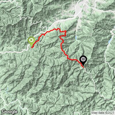
The first 3.7 miles of this climb are on Dark Ridge Road to Old Balsam Depot Road to Cabin Flats to Candle Stick Lane to Great Smoky Mountains Exwy to BRP (see map).  It really sounds worse than it really is - it’s pretty simple if you follow a paper or digital map.

Cycling Richland Balsam, Blue Ridge Parkway - bike parked against sign for Trinity Baptist Church, old white church building with steeple, road sign reads "Church Entrance"

Trinity Missionary Baptist Church at mile 0.8.

Cycling Richland Balsam, Blue Ridge Parkway - photo collage, town of Balsam, bike parked on train tracks, abandoned Knight's Store with brush growing up against building, PJAMM Cycling logo in corner

Pass through town of Balsam at mile 3

Photo bottom middle:  Knight’s Store, abandoned since 1979.

The population of Balsam as of the 2000 (and most recent census) is about 160.  Balsam is named after the Blue Ridge Mountain trees: the red spruce (he-balsam), and the Fraser fir (she-balsam).

Cycling Richland Balsam, Blue Ridge Parkway - inside and outside views of the Grand Old Lady Hotel, formerly the Balsam Mountain Springs Hotel, historic building

The Grand Old Lady Hotel (formerly Balsam Mountain Springs Hotel).

I stumbled across this iconic and historical Victorian hotel on my climb up to Richland Balsam.  It was closed for COVID-related upgrades in early October 2020 when we rode through.  Formerly the Balsam Mountain Springs Hotel and Balsam Mountain Inn, this is a perfectly preserved link to days gone by.  Constructed in 1905, the Inn began as a railroad resort hotel, and was very popular with citizens of the Asheville area 40 miles east.  

Photo:  Grand Old Lady Hotel

Marzena Wyszynska, the hotel’s owner since 2017, was kind enough to let me photograph the bottom floor of the hotel.

“Balsam Gap was once home to the highest passenger rail station in the east, and guests at the inn - then called the Balsam Mountain Springs Hotel - took day trips to nearby peaks, some of which rise to over 6,000 feet. Our guests still enjoy such trips - even more so perhaps - by hiking the nearby North Carolina Mountains-to-Sea Trail, or by driving the spectacular Blue Ridge Parkway, which has an entrance a half-mile from the inn and reaches some of its highest, wildest and most beautiful points nearby,” (read more here).

Cycling Richland Balsam, Blue Ridge Parkway - photo collage, getting on to Blue Ridge Parkway at mile 3.7, train tracks cross intersection, stop sign, PJAMM Cycling logo in corner

It’s a bit confusing getting onto the Parkway at mile 3.7.

You are on Route 23 (Great Smoky Mountains Expressway) for about 20 yards, then turn right onto Ranger Lane.  The somewhat confusing part is that there is a sign that says “no thru traffic,” but you can ride your bike the 50 yards up to the Blue Ridge Parkway without any trouble.

BLUE RIDE PARKWAY OVERLOOKS

There are over 200 overlooks along the 469 mile Blue Ridge Parkway.  I am unaware of any road in the US with more scenic overlooks.  The best site for information on the BRP overlooks that I have found is Virtual Blue Ridge which provides information on each overlook and, in most instances, has a 360 degree photo of the overlooks.

Cycling Richland Balsam, Blue Ridge Parkway - Standing Rock Overlook, panoramic views of scenic fall foliage, bike parked against overlook sign

PJAMM climb mile 5.4 / BRP mile 441.4.

“Standing Rock Overlook, Milepost 441.4 - Elevation: 3915':  The abundant Fall colors at the Standing Rock overlook makes you want to be there enjoying them in person. The Standing Rock is at the south end of the parking area of the overlook. The huge rock seems out of place among all of the trees,” (Virtual Blue Ridge).

Cycling Richland Balsam, Blue Ridge Parkway - View Waynseville scenic overlook sign, bike parked at overlook sign, fall foliage, mountain vistas

PJAMM Climb mile 6 / BRP mile 440.9.

“View Waynesville, Milepost 440.9 -Elevation: 4110': Waynesville is seen below the Plott Balsam range. Legend says Waynesville was named for “Mad” Anthony Wayne, who served in the Revolutionary War,” (Virtual Blue Ridge).

Cycling Richland Balsam, Blue Ridge Parkway - scenic overlook sign reads "View Village of Saunook," bike parked at sign, bright fall foliage

PJAMM mile 6.8 / BRP mile 440.0.

Cycling Richland Balsam, Blue Ridge Parkway - scenic overlook sign reads "Cove Field Ridge Overlook," bike parked along trail at overlook sign, orange fall foliage

PJAMM mile 7.6 / BRP mile 439.4.

Cycling Richland Balsam, Blue Ridge Parkway - scenic overlook sign reads "View Steestachee Bald," bike parked on trail against overlook sign, dense fall foliage, foggy skies

PJAMM mile 8 / BRP mile 438.9.

Cycling Richland Balsam, Blue Ridge Parkway - BRP Scenic Overlook sign reads "Grassy Ridge Mine Overlook," bike parked against overlook sign, fall foliage, bright blue sky, clouds below

PJAMM mile 10.3 / BRP mile 436.8.

This overlook is just before the only descent on the climb, which is 0.9 miles at -2.4%.

“Grassy Ridge Mine Overlook, Milepost 436.8 - Elevation: 5250':  Below the overlook is the remains of a mica mine which was operated until about 1950. Mica is deposited in very thin sheets and is a silvery brittle substance. Mica used to be important because of its insulating qualities and was used in a lot of electrical equipment. The development of plastics rendered mica obsolete,” (Virtual Blue Ridge).

Cycling Richland Balsam, Blue Ridge Parkway - BRP scenic overlook sign reads "View Doubletop Mountain," bike parked against overlook sign, bright fall foliage, blue sky

PJAMM mile 11.8 / BRP mile 435.3.

“View Doubletop Mountain, Milepost 435.3 - Elevation: 5365': This parking area is situated on Flat Gap, which was used by loggers and hunters as a campsite in the 1800s. Below is Deep Ridge Creek where a Cherokee village was located up until 1781 when it was destroyed by whites. At that time the Cherokees were allied with England,” (Virtual Blue Ridge).

Cycling Richland Balsam, Blue Ridge Parkway - photo collage, BRP scenic overlook sign reads "Roy Taylor Forest Overlook," bike parked on pathway against overlook sign, bright blue sky, mountain views, fall foliage

PJAMM mile 13.7 / BRP 433.3.

“Roy Taylor Forest Overlook, Milepost 433.3 - Elevation: 5580': A paved trail leads to this overlook,” (Virtual Blue Ridge).

Cycling Richland Balsam, Blue Ridge Parkway - BRP Scenic overlook sign reads "Lone Bald Overlook," bike parked against sign on pathway, bright blue, sunny sky, bright orange fall foliage on hillsides surrounding

PJAMM mile 14.3 / BRP 432.7.

“Lone Bald Overlook, Milepost 432.7 - Elevation: 5635':  At one time a red spruce, or he-balsam, stood on what was then known as Lone Balsam Mountain. One day the tree fell, and the mountain is now known as Lone Bald,” (Virtual Blue Ridge).

Cycling Richland Balsam, Blue Ridge Parkway - scenic overlook sign reads "Richland Balsam Overlook," informational sign on forest decline, bike parked against signage, bright blue skies, tall evergreen trees, fall foliage

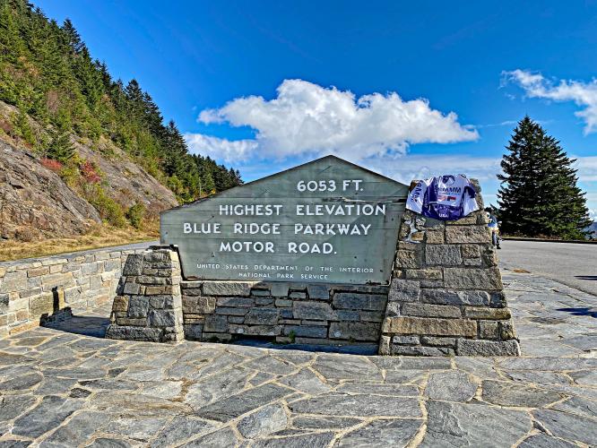
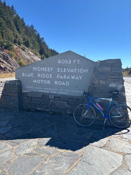
PJAMM finish / BRP 431.4.

“Richland Balsam Overlook, Milepost 431.4 - Elevation: 6053':  This self-guiding trail walks you through the remains of a spruce-fir forest. The highest point of the Parkway is found here at 6053 feet. The overlook gives views of the southern Appalachians. From here the Cowees, Nantahalas and Plott balsams can be seen,” (Virtual Blue Ridge).

Cycling Richland Balsam, Blue Ridge Parkway - bike parked against sign for Pinnacle Ridge Tunnel, stone tunnel entrance way surrounded by dense foliage, evergreens and fall colors

Pinnacle Ridge Tunnel: 0.18 miles at 1.8%.

Bring at least a rear light.

Cycling Richland Balsam, Blue Ridge Parkway - PJAMM Adventure App shows climb grade and profile and finish

PJAMM Adventure App showing stats at climb finish.

Access to full Climb Summary requires a PJAMM Cycling PRO Membership!

It takes less than a minute to sign up & with your PRO membership you can:
  • Rate climbs, post comments and share your experiences on any of our climb pages
  • Create bucket lists of climbs & mark the dates you complete them
  • Weather data for all climbs - Start & Finish
  • Upload photos to your member page to customize your PJAMM Cycling experience
  • Utilize all of our interactive tools - Profile & Routes in Area
  • Download climb route .gpx files
LEARN MORE
SIGN UP

Already have an account? LOG IN HERE