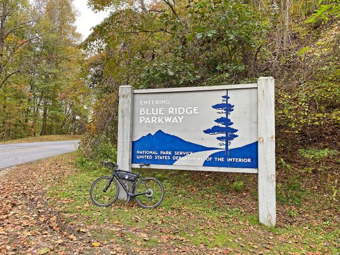
Cycling the Blue Ridge Parkway
Ride 469.7 miles gaining 52,290’
Special PJAMM summary by John Summerson, the authority on climbing by bike in the United States (The Ultimate Guide to Climbing (by Bike) 2nd Ed. and many more US climbing books):
“It has been called the ultimate bicycling road and there may not be a route more ideal for two-wheel riding. The Blue Ridge Parkway carries you through a large portion of the Blue Ridge and Appalachian Mountains, from Afton in northern Virginia to Cherokee in southwest North Carolina. A cycling environment with mostly smooth pavement without commercial vehicles and through scenic, mountain landscapes sounds like a dream.
However, be careful what you wish for as the way is certainly not easy. At 469 miles, cycling its full length is essentially equivalent to riding four major tour big mountain stages over consecutive days. The route is almost constantly either uphill or down and you will work to get through it. It is also a fairly narrow, two lane road so keep this in mind if you set out to ride all of it or just a portion.
At such a long distance, many other roads intersect its length. As the Parkway is also located at altitude (for the eastern seaboard), either on top of or high on the ridgeline, most of these lanes have to climb significant amounts to reach it. Of course, this creates just what climbers desire, a steady supply of challenging ascents along the way.”

A little bit about the Blue Ridge Parkway:
- 469 miles
- Gain 52,290’ on the ride
- High point: 6,047’ at Richland Balsam Overlook (mile 433)
- Low point: 649’ at the James River (mile 70)
- Steepest extended segment is 13 miles at 4.8%, ending at Apple Orchard Mountain Overlook at mile 77
- 15 visitor centers.
- Over 200 viewpoints/overlooks
- Highest and longest continuous road in the Appalachian Mountains
- First rural parkway to be conceived, designed, and constructed for a leisure-type driving experience (Blue Ridge Parkway Foundation)
- Tourism on the Parkway brings nearly a billion dollars annually to the 29 counties through which it passes
- 369 miles of hiking trails (NPS.gov)
- Hike parts of the Appalachian Trail and Mountain to Sea Trail in and around BRP.
BLUE RIDGE PARKWAY BIKE RIDE
SUMMARY BY PJAMM’S BRAD BUTTERFIELD
In Mid-March of 2022 I finally had the opportunity to do my first bike-packing trip -- on one of the most beautiful byways in the US.
![]()
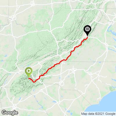
The plan (and I say “plan” loosely) was a 700 mile, nine day, jaunt heading (mostly) North along the Blue Ridge Parkway. On March 16th, beginning in the pouring rain, I set out from Asheville, North Carolina en route to Cherokee, NC. Despite this being my first bike-packing trip, it was far from my first uphill accent into frigid mountain air in the rain. Which is to say, I should have had the smallest amount of wisdom to bring some proper cold weather gear. I think I was just too excited to start my journey though. All I wore was a thin cotton zip up sweater and some basic gloves. Life would be so boring if everything was well planned though!

On the Blue Ridge Parkway between Asheville and Cherokee, you’ll climb up to the highest point of the entire Parkway, at 6,053 feet. There are two major ascents and essentially no flat portions en route. My Strava tracked over 10,500 feet of vertical gain that day.
![]()
On day two, I rode Out of Cherokee up into the Great Smoky Mountains National Park. While still technically in the “Off Season,” the National Park Roads were still very busy. Conditions on my second day could not have been more ideal. Even up near 6,000 feet heading over the pass towards the Sugarlands visitor center, the sun shone brightly enough to keep me warm. I also did a bit of extra credit that second day, riding the closed-for-construction road up the Clingmans Dome. Up at the Dome I was entirely alone with a 360-degree view of the Blue Ridge Mountains. I found it especially amazing that no telephone poles, houses, or roads are in view from the Dome: a totally untouched landscape as far as the eye can see.

Cligman’s Dome

I nearly coasted the entire 30 miles back to Cherokee from Clingman’s Dome, keeping enough speed in some portions to pass cars on the way. The next day I rode the same route as the first day, but in reverse back to Asheville. Mother Nature offered up another soggy day and I rode completely fogged in for nearly five hours. With over 30,000 feet of elevation gain in the first three days, it was important to make sure my tank stayed topped up -- and there’s no better way than a pizza to accomplish this. I downed an entire large Domino’s pizza in my SUITE that night in Asheville. That’s right, SUITE! The hotel had been overbooked and they offered to upgrade my double room at no charge. To my eye, the best portion of the Parkway is the winding route from Asheville to Little Switzerland. This portion of the Parkway was still closed to cars for the season too. You can imagine I was feeling a lucky man having a SUITE for the night AND an, essentially, private road to enjoy for the day.

Here I should say though, if you are riding the Parkway in the off season, be prepared to be self-sufficient. There were no running water spigots or active snack refuels along the route. Additionally, much of the day I had no cell coverage. Along with carrying spare tubes and patches, I think it’s wise to plan for the worst if you are riding this route in the off season. It’d be a very long walk if you had a mechanical issue out there. Apart from a flat tire, the two other *semi-common* showstoppers that I planned for were a broken spoke (a three-way spoke wrench is small and easy to pack) and a ‘quick-link’ along with a chain tool. Of course total disaster could always happen, like a broken crank or something freak, but this isn’t worth worrying about in my opinion. You’ve got to trust you’re at least going to have some luck, right? Well, that’s how I operate at least (but I also brought no cold-weather gear so…). And on that note, I only brought two water bottles for day four’s eight-hour ride from Asheville to Pineola (I couldn’t stay at Little Switzerland as they were still closed for the season). Luckily, I refilled my bottles in a small stream near the road about halfway through the day. Still, I was fiercely thirsty by the time I reached the hotel in Pineola.

On day five the temperature dropped thirty degrees from the previous day and the winds were absolutely ripping the east. From Pineola to West Jefferson, the Blue Ridge Parkway leaves the serious mountains behind and enters more developed land. Here I passed dozens of homesteads, nearly all with horses, cows, chickens, or all of the above. The wind on day five was the strongest I have ever ridden through. In fact, as I was coasting down a hill a random gust blew me off the road completely. Thank goodness my lucky stars were working overtime that day, as the shoulder was a flat strip of grass and I was able to keep the bike upright. The winds were much calmer on day six and I rode a relaxed sixty-five miles from West Jefferson, North Carolina into Galax, Virginia.

Much of the land along this portion was developed as well, although once I crossed into Virginia the homes were far more modest than those in North Carolina. From Galax, on the seventh day (he did not rest) it was 80 miles to the Bent Mountain Lodge. The tough climbs seemed to be behind me by this point, but the Parkway is never flat. I still climbed a cool 7,000 feet on the seventh day. The Bent Mountain Lodge is a must while touring the Blue Ridge Parkway. It is just a mile from the Parkway and owned by a generous older couple. They fed me dinner and we shared homemade banana bread over breakfast the following morning as the heavens dumped rain audibly on the roof outside. Yes, the rains had returned for day eight of my journey. And on day eight too, my body seemed to rebel against me. The first real feeling of fatigue had wormed its way into my legs. It was meant to be a shorter day on the bike up towards Bedford, Virginia. But closed portions of the Parkway led to some long detours. The first closed section was due to a landslide and I was able to creep around the fence. But, the second fence was un-hoppable. Of course, then I got Lost in Roanoke -- which seems like a song title.

The ‘Peaks of Otter Lodge I had planned to stay at was still closed for the season when I arrived just before sunset. After the long, unplanned Detour in the Downpour (hey, there's another song title…maybe I’ve spent too long in Nashville) and frigid temperatures, my body had submitted into a cruel shiver, so I climbed into an open storage closet at the lodge to get out of the rain and make a plan for escape. Sometimes thinking in that sort of state can lead to a worsening of the problem, so I wanted to make sure I thought things through. I connected to the lodge wifi and found that Bedford was a ten mile descent away. Thankfully, I didn’t have to ride there. As I was clipping in to begin my ride, a truck pulled into the parking lot and I flagged him down. It was a couple from Boston that had just “gone out for a drive.” They weren’t heading anywhere specifically and said they wouldn’t mind saving my carcass. “You look awful,” the man said to me, haha! The final day of my journey north was a ninety mile ride from Bedford to Waynesboro. The clouds came out in force, but the rain held out for me. This final portion of the Parkway is, again, mostly undeveloped and remote. Only a few cars passed me all day.
Being from the west coast, I have grown accustomed to the Rocky Mountain and Pacific Northwest routes and scenery. The Blue Ridge Parkway through the Appalachian Mountains was a fresh reminder to me of how much the USA has to offer cyclists. This route is a must for any adventure seeking cyclist. Along with stunning views and pristine roads, I found the local culture and history to be especially interesting along the route. Towns like Bedford have been around since the 1780s. A lot has changed in this part of America, but a surprising amount has stayed the same. I’ll be back some day soon to explore the vast amount I still have yet to explore out there. But, for this time, Waynesboro was the end of the road for me.