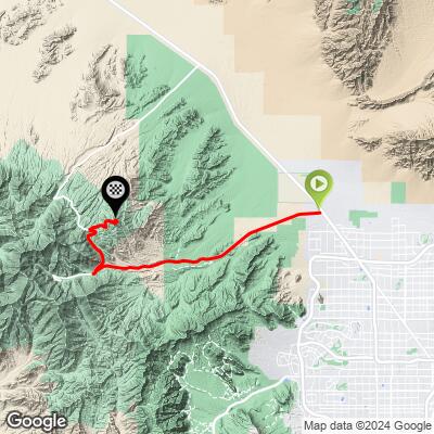
32.7
PDI
25.2 mi
DISTANCE
6,318 ft
GAINED
4.5 %
AVG. GRADE
FULL CLIMB STATS
Page Contributor(s): Ron Hawks, Las Vegas, Nevada, U.S.A.
INTRO
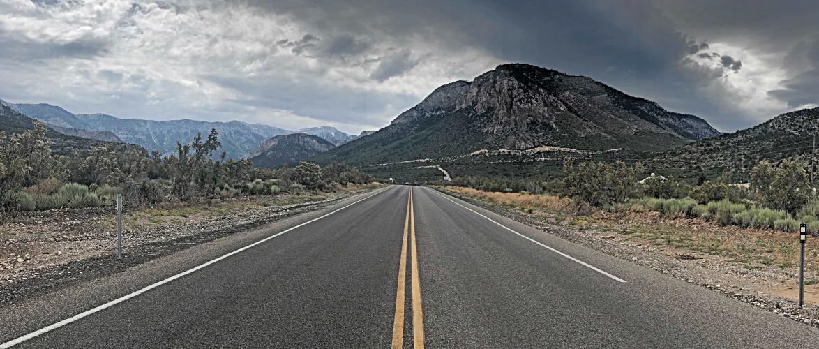
The first nine miles of the Kyle Canyon climb are in a somewhat bleak high desert environment. At around nine miles we begin to enter a canyon-like setting with more interesting views and rock formations. We enter Spring Mountain National Recreation Area at mile 12.2 and reach the turnoff to Highway 158 at mile 17.5 (3,986' climbed at 4.6% average grade to this point). The final four miles up Highway 158 are at 5.8%, climbing 1,325' with some very good views of the Kyle and Red Rock Canyon National Conservation Area to the southeast.
PLAN YOUR ROUTE
4.7% average grade. 61% of the climb is at 0-5% grade and 37% is at 5-10%. The steepest quarter-mile is 7.9% and steepest mile 7.2%.
See more details and tools regarding this climb's grade via the “Profile Tool” button.
Roadway: This is a two lane highway in excellent condition with a shoulder to ride your bike in up to the turn onto Highway 158 at mile 17.5. The last four miles on Highway 158 are on excellent pavement and with a much narrower shoulder.
Traffic: Mild to Mild-Moderate on Highway 157 with traffic passing at highway speeds - 50-60 mph. This is not a ride for the traffic averse, although you can ride on the shoulder the entire 17.5 miles on Highway 157. Traffic on Highway 158 is mild.
Parking: Near climb start (Map; Street View).
Provisions: None on the route (in an emergency you could probably get water and an expensive meal at the Retreat on Charleston Peak at mile 17). If Mt. Charleston Lodge is open, there will be food and beverages there - this is 3.5 miles up Highway 157 from the turn off to Highway 158 (Map).
Weather: This climb is in the Mojave Desert and the average high for June-August is 99-104. Additionally, you finish the climb nearly 5,000' above your starting altitude. Therefore, be sure to consult the PJAMM "Full Forecast" feature for the time you expect to arrive at climb start and finish to assess what clothing to bring on your ride.
Before heading out on any cycling adventure check out our Things to Bring on a Cycling Trip and use our interactive check list to ensure you don't forget anything.
This climb begins fifteen miles north of Las Vegas. There are three other Top US 100 Bike Climbs in this area. Use the “Routes in Area” button on the menu bar to see other bike climbs in this area.
We stayed in Las Vegas when we did these climbs and drove the 18 miles from Vegas to this climb for our long riding day.
Also consider cycling in Death Valley, which is only two hours west of Las Vegas, and Zion National Park, which is only 2.5 hours northeast. See our Death Valley National Park page and our Zion National Park page for more information on riding in these areas.
ROUTE MAP
MEMBER RATING
CURRENT WEATHER
PJAMM TRIPS ADVENTURE STARTER BUNDLES
Check out PJAMM Adventure's prepackaged (self-guided) cycling trips. They will help you plan, document and conquer your next adventure.
NEARBY CLIMBS (0) RADIAL PROXIMITY
FROM No Climbs Found
MEMBER REVIEWS & COMMENTS
Let us know what you thought of this climb. Signup for our FREE membership to write a review or post a comment.
Already have an account?
LOG IN HERE
cheminant
The climb as shown here enters private property. There is a gate at mile 23.3. I was stopped by security officers just past there and told it was private property and no one was allowed. The route needs to be updated so the top is at 36.31264845566142, -115.58685866546584. Otherwise some cyclist is going to get arrested.