Mount Meenagah Road Bike Climb - PJAMM CyclingMount Meenagah Road Bike Climb - PJAMM Cycling

10.3
PDI
3.3 mi
DISTANCE
1,453 ft
GAINED
8.5 %
AVG. GRADE

FULL CLIMB STATS

INTRO

The first 1.7 miles of this climb overlap Sam’s Point (NY #7). It was an overcast day in June 2020 when we did this climb but it was very enjoyable - no traffic and thick forest bordering the final half of the climb.

PLAN YOUR ROUTE

We've partnered with Sherpa-Map.com to bring you the best route planning tool. With a PRO Membership you can use this climb as a reference when creating your route.

PROFILE CLICK IMAGE or BUTTON FOR INTERACTIVE TOOL

Grade is 8.5% over 3.3 miles gaining 1,460' with 0 descent.  60% of the climb is at 5-10% grade, 26% is at 10-15%, and 1.7% is at 15-20%.  The steepest quarter-mile is 13.2%.

See more details and tools regarding this climb's grade via the “Profile Tool” button.
Roadway:  The first 4/10ths of the climb are on Highway 52 which is in good condition with a shoulder up to the turn-off onto Mt. Meenagah Road, which is in fair condition with no center stripe or shoulder. 

Traffic:  Moderate on Highway 52 and mild on Mount Meenagah Road. 

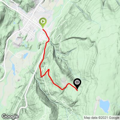
Parking:  We parked on the side of Broadhead Street just past the climb start (Map; Street View). 
Provisions:  There are no places to get food or water on the ride, but there are plenty of spots in Ellenville where the climb begins. 
Before heading out on any cycling adventure check out our Things to Bring on a Cycling Trip and use our interactive check list to ensure you don't forget anything.
The first 1.5 miles of this climb overlaps Sam's Point Road.  Use the “Routes in Area” button on the menu bar to see other bike climbs in this area with a high concentration of Catskill bike climbs.

ROUTE MAP

MEMBER RATING

Not Yet Rated
-
Road
-
Traffic
-
Scenery

CURRENT WEATHER

PJAMM TRIPS ADVENTURE STARTER BUNDLES

Check out PJAMM Adventure's prepackaged (self-guided) cycling trips. They will help you plan, document and conquer your next adventure.
ALL TRIPS
Browse all of our prepackaged trips and find your next adventure!
Northeast Fall Colors
United States (MA,ME,NH,NY,VT)
24 ROUTES
37 POIs
ROUTE STATS (TOTAL)
98
mi
DISTANCE
35,116
ft
ELEV. GAIN

NEARBY CLIMBS (0) RADIAL PROXIMITY

FROM
No Climbs Found

MEMBER REVIEWS & COMMENTS

Let us know what you thought of this climb. Signup for our FREE membership to write a review or post a comment.
Already have an account?
ROUTE MAP
PROFILE TOOL

Mount Meenagah Road

STREET VIEWS
Explore the climbing route via Google Street Views.
IMAGES
View epic images taken along the climbing route.
SEGMENT
Select a portion of the route to retrieve climb & profile data for that segment.
GRADIENT
See where the steepest portions of the climb are located by gradient group.
Gradient
30%
20%
10%
0%
Route Data
S.G. (%)
hide

Steepest Gradient (%)

13.1
0.25 mi
12.2
0.5 mi
10.3
1 mi
9.2
2.5 mi

Click on above gradient to display on profile.

Drag Knobs to Select Segment

Route Data
S.G. (%)
hide

Steepest Gradient (%)

13.1
0.25 mi
12.2
0.5 mi
10.3
1 mi
9.2
2.5 mi

Click on above gradient to display on profile.

Segment Data
hide
CLIMB SUMMARY

Cycling Mount Meenagah - New York #5 bike climb

Ride 3.3 miles gaining 1,460’ at 8.5% average grade.

The first 1.7 miles of this climb overlap Sam’s Point (NY #7). It was an overcast day in June, 2020 when we did this climb but it was very enjoyable - no traffic and thick forest bordering the final half of the climb.

This climb is entirely within the Minnewaska State Park Preserve (est. 1993; 22,275 acres).

We begin this climb on Hwy 52 at the eastern edge of Ellenville (2010 population 4,135).  Structures were first built in this area in 1798.

Access to full Climb Summary requires a PJAMM Cycling PRO Membership!

It takes less than a minute to sign up & with your PRO membership you can:
  • Rate climbs, post comments and share your experiences on any of our climb pages
  • Create bucket lists of climbs & mark the dates you complete them
  • Weather data for all climbs - Start & Finish
  • Upload photos to your member page to customize your PJAMM Cycling experience
  • Utilize all of our interactive tools - Profile & Routes in Area
  • Download climb route .gpx files

TRY PRO FREE FOR 7 DAYS

LEARN MORE
SIGN UP

Already have an account? LOG IN HERE

BESbswy