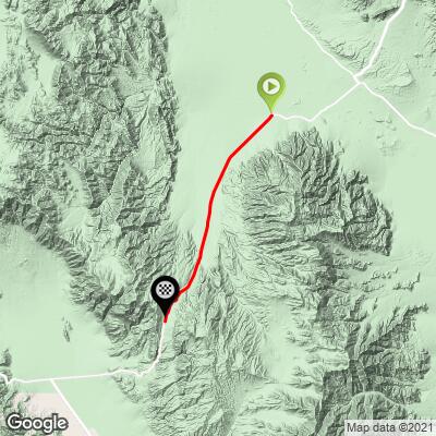
Towne Pass North Bike Climb - PJAMM Cycling

9
FIETS
16.9 mi
DISTANCE
4,968 ft
GAINED
5.6 %
AVG. GRADE

FULL CLIMB STATS

INTRO

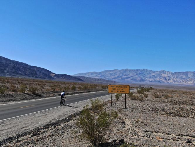
Towne Pass North is a long and challenging bike climb in Death Valley that is ranked #52 on the US Top Bike Climb list.  The first several miles of this climb seem almost flat and we are definitely in an arid, desert-like setting.  Be prepared to be riding into a significant head wind most of the climb. 
This is more grind it out than up in the saddle double digit grade.  The average grade on the climb is 5.6% gaining 4,956' with negligible descent.  36% (6.1 miles) is at 0-5% grade, 52% (10.5 miles) is at 5-10%, and 1.2% (0.2 miles) is at 10-15%.  The steepest quarter-mile is 9.6% and steepest mile 9%. 

See more details and tools regarding this climb's grade via the “Profile Tool” button.
Roadway:  Two lanes in excellent condition with no shoulder, but line of sight for miles throughout most of the climb. 

Traffic:  Mild but moving at 55-60 mph.  However, it is impossible for an attentive driver to miss you on this roadway - there are no visual obstructions. 

Parking:  At Stovepipe Wells at the start of the climb - MapStreet View
Provisions: There are no provisions on this ride so be absolutely certain to bring enough water and food.
 
Weather: It is torturously hot in Death Valley during the hot season.  The average high temperature at this time is between 109 and 116 degrees.  Consult the PJAMM "Full Forecast" feature for temperatures at the start and finish of your climb to be well prepared for the ride.
Before heading out on any cycling adventure check out our Things to Bring on a Cycling Trip and use our interactive check list to ensure you don't forget anything.
We have always stayed in Stovepipe Wells at the Stovepipe Hotel and Restaurant when doing bike climbs in the western side of Death Valley.  We enjoy staying at Stovepipe as it has a gas station, nice and reasonable rooms, a store, and a restaurant-bar.  

Once we did the Towne Pass North and Towne Pass West on the same day which is a challenge, but manageable - 52 miles gaining 8,350' (Map). 

See our Death Valley National Park page for more details about all the bike climbs and lodging Death Valley. 

ROUTE MAP

MEMBER RATING

Difficulty: Strenuous
5
Road
3
Traffic
3
Scenery

CURRENT WEATHER

PJAMM TRIPS ADVENTURE STARTER BUNDLES

Check out PJAMM Adventure's prepackaged (self-guided) cycling trips. They will help you plan, document and conquer your next adventure.
ALL TRIPS
Browse all of our prepackaged trips and find your next adventure!
Death Valley
United States (CA)
21 ROUTES
34 POIs
ROUTE STATS (TOTAL)
553.3
mi
DISTANCE
55,125
ft
ELEV. GAIN
Owens Valley: Bishop
United States (CA)
19 ROUTES
26 POIs
ROUTE STATS (TOTAL)
268.3
mi
DISTANCE
55,531
ft
ELEV. GAIN
Owens Valley: Lone Pine
United States (CA)
15 ROUTES
31 POIs
ROUTE STATS (TOTAL)
157.7
mi
DISTANCE
51,016
ft
ELEV. GAIN

NEARBY CLIMBS (0) RADIAL PROXIMITY

FROM
No Climbs Found

MEMBER REVIEWS & COMMENTS

Let us know what you thought of this climb. Signup for our FREE membership to write a review or post a comment.
Already have an account?

Mar 24, 2023
March 20, 2023, snowing at the summit
Mar 24, 2023
There is plenty of potable water at the Emigrant Campground at about mile 9. One faucet is by the toilets, one is by the campground.
Apr 30, 2021
difficulty: Strenuous
scenery: 3
traffic: 3
road: 5
Apr 30, 2021
scenery: 3
traffic: 3
road: 5
This is a difficult climb as it just seems to go on forever. The lower part is more undulating, so it alternates between flatter and steeper ramps. Above 3,000 feet is where the grind really starts. Wind and heat can make it even more difficult. I did the climb once with a strong headwind that made forward progress difficult in places. On the descent it was difficult to stay UNDER 60 mph. Load up on water and supplies in Stovepipe Wells (hint: fill your bottles with ice if it's hot).
ROUTE MAP
PROFILE TOOL
Route Data
S.G. (%)
hide
Segment Data
hide

Climb Profile Not Found
CLIMB SUMMARY

Cycling Towne Pass, Death Valley  - cyclists with bikes at Death Valley National Park Sign 

Cycling Towne Pass East

Start the climb in Stovepipe Wells, California.

Visit our Death Valley National Park page for more rides in the area.

We have a lot of history with this iconic unique bike climb. Ride 16.9 miles gaining 4,979’ to elevation 4,962’ at 5.6% into a powerful wind.


Climbing by bike Towne Pass, Death Valley  - elevation 0 sign with cyclist next to it

Stovepipe Wells.

Elevation =  .


PJAMM Cycling riding to Whitney Portal from Badwater, 116° at the start.

Here we are at the start of Towne Pass at 11pm, and still 105°.

Then - hike eight miles to the highest point in the Continental US.

Towne Pass East begins a mile west of  Stovepipe Wells, CA and is the highest ranked climb in Death Valley, at #50 on the Top 100 cycling climbs list.  We begin this climb in the heart of Death Valley at sea level and ride into what will likely be a powerful headwind.

The first several miles of this bicycle climb seem almost flat and we are definitely in an arid, desert-like setting. It is Death Valley, afterall.

Climb Towne Pass, Death Valley by bike - cyclist on bike on Hwy 190 passing 1000' elevation sign

Bicycle ride Towne Pass, Death Valley  - bike leaning against Hwy 190 sign near road

Ride on Highway 190 for the first 9.3 miles -- share this segment with Emigrant Pass East.

All Death Valley climbs have rollers, to varying degrees.

Stovepipe Wells is center right in photo (view east 4.6 miles from start).

Aerial photo looking east towards Stovepipe, six miles down the road.

Stovepipe to the right around the redish bluff point in upper middle third of photo.

Ground view looking back down the mountain at mile six.

Pass Emigrant Campground at mile 9.3 (turn left here for the Emigrant Pass East climb).  To this point we have travelled (9.3 miles at 4.5% average grade gaining 2,187’.

Emigrant Campground -- turn left off Highway 190 onto Emigrant Canyon Road here.

We begin to climb into more mountainous, yet stark, landscape around miles seven and eight.

Great descent, tough climb!

As of October 2014, there was water at the nine mile point at Emigrant Campground. There is very little vegetation along this climb, and no trees. As with most of the Death Valley climbs, the views are very stark and high desert-like. This climb is one of the less scenic of the five Top 100 climbs located in Death Valley, but certainly a cycling challenge and can be done in conjunction with #90 Towne Pass West (an over-and-backer) or unranked Emigrant Pass East (visit the Death Valley main page for more information on that climb).

Towne Pass (previously called  Townsend Pass  in the distant past) is named after a man named Townsend who saved emigrants stranded in Death Valley in the mid 19th century.  

IMG_2393.JPG

#9 climb on of our 2014 Death Valley climb trip.


John at the top of Towne Pass during Badwater to Whitney ride in 2017.

That’s a wrap!

DEATH VALLEY WEATHER

National Park Service Death Valley Weather Chart.

Warning: Do NOT attempt these climbs in the summer, when the average​ high temperatures range from 106°-116° between May and September.

Average high temperature in July is 116°F/46.6°C.

The hottest temperature ever recorded on earth was in Furnace Creek on July 10, 1913 (134℉/56.7℃) and, while that record has been challenged, the “alternate” record is also held by Death Valley in 2013, when it was 129.2℉/54.0℃ (in a tie with Mitribah, Kuwait which recorded that same temperature in 2016).

July 2017 -- Badwater to Mt. Whitney Summit.

116° is the average high temperature in July!

Cycling Death Valley - pjamm cycling ride bikes through death valley

OK!  I didn’t take my own advice in July, 2017.  😨

Traffic and Roadway Surface Report:  As of October 2019, the roadway surface was excellent throughout this ride, but there is minimal to no shoulder and traffic can zoom by at highway speeds.  

Access to full Climb Summary requires a PJAMM Cycling PRO Membership!

It takes less than a minute to sign up & with your PRO membership you can:
  • Rate climbs, post comments and share your experiences on any of our climb pages
  • Create bucket lists of climbs & mark the dates you complete them
  • Weather data for all climbs - Start & Finish
  • Upload photos to your member page to customize your PJAMM Cycling experience
  • Utilize all of our interactive tools - Profile & Routes in Area
  • Download climb route .gpx files
LEARN MORE
SIGN UP

Already have an account? LOG IN HERE