Grand Mesa South Bike Climb - PJAMM Cycling

8.8
FIETS
19.1 mi
DISTANCE
4,710 ft
GAINED
4.6 %
AVG. GRADE

FULL CLIMB STATS

Page Contributor(s): Todd Short, Scottsdale, AZ; Bruce Hamilton, La Quinta, CA; Stacy Topping, Tacoma, WA,

INTRO

"The south side of Grand Mesa is a very long and scenic climb. There is a bit of traffic at the start in town but not enough to ruin the ride. The vehicles and town are soon left in your rear view mirror as you begin over shallow grade which tends to gradually increase as you ride into thicker tree cover. An unspectacular lower end eventually gives way to ridge views in places and lakes once into the National Forest. The grade is quite steady throughout with no surprises and through a few big switchbacks. You pass Grand Mesa Lodge near the top and the listed climb ends soon after among thick trees at the Mesa County line at almost 11,000 feet of elevation." (This quote is presented with the approval of John Summerson, from his book, The Complete Guide to Climbing (by Bike) in Colorado, pg. 126.)
4.6% average grade - 52% of the climb is at grade 0-5% and 40% is at 5-10%.  The steepest quarter-mile is 9.3% and steepest mile 6.8%.

See more details and tools regarding this climb's grade via the “Profile Tool” button.
Roadway:  Two lane Scenic Byway Route 65 is in very good condition with an approximate 2' shoulder most of the climb.  

Traffic:  Mild to moderate traveling at highway speeds (45-55 mph) for the most part.  If you are traffic averse, begin this climb about half-way up the mountain as traffic is milder the further we climb.  We have ridden this climb and the route from the north twice each and have felt safe on each ascent. 

Parking:  In Cedaredge on Main Street at the start of the climb - MapStreet View
Provisions:  There are no provisions on the climb - there are markets and restaurants in Cedaredge at the start of the climb and in Mesa on the backside of the climb, 39 miles from the start - Map.

Weather and Gear
:  We climb to nearly 11,000' and finish about 5,000' above where we begin.  Be sure to consult the PJAMM "Full Forecast" feature for the time you expect to arrive at the finish to assess what clothing to bring on your ride.
Before heading out on any cycling adventure check out our Things to Bring on a Cycling Trip and use our interactive check list to ensure you don't forget anything.
A challenging out and back climb is to tack on Grand Mesa North to this climb - 80 miles and 10,440' of climbing - Map.

Use the “Routes in Area” button on the menu bar above to see other bike climbs in this area.  A fantastic climb not to miss if your are in the area is East Portal, about 50 miles south in the Black Canyon of the Gunnison National Park.

We have stayed in Montrose when we have done this climb, but we would recommend staying in Cedaredge as it seems like a quainter town. 

ROUTE MAP

MEMBER RATING

Not Yet Rated
-
Road
-
Traffic
-
Scenery

CURRENT WEATHER

PJAMM TRIPS ADVENTURE STARTER BUNDLES

Check out PJAMM Adventure's prepackaged (self-guided) cycling trips. They will help you plan, document and conquer your next adventure.
ALL TRIPS
Browse all of our prepackaged trips and find your next adventure!
Colorado: Front Range
United States (CO)
20 ROUTES
46 POIs
ROUTE STATS (TOTAL)
563.5
mi
DISTANCE
73,545
ft
ELEV. GAIN
RMNP: Trail Ridge Road
United States (CO)
13 ROUTES
33 POIs
ROUTE STATS (TOTAL)
258.2
mi
DISTANCE
25,530
ft
ELEV. GAIN
Utah: Moab, Arches & Canyonlands
United States (UT)
19 ROUTES
21 POIs
ROUTE STATS (TOTAL)
325.3
mi
DISTANCE
32,871
ft
ELEV. GAIN

NEARBY CLIMBS (0) RADIAL PROXIMITY

FROM
No Climbs Found

MEMBER REVIEWS & COMMENTS

Let us know what you thought of this climb. Signup for our FREE membership to write a review or post a comment.
Already have an account?
ROUTE MAP
PROFILE TOOL
Route Data
S.G. (%)
hide
Segment Data
hide

Climb Profile Not Found
CLIMB SUMMARY

Cycling Grand Mesa North - daisy flower, horses, gray skies

Cycling Grand Mesa South, a top US bike climb in the Rocky Mountains.

Ride 19.1 miles gaining 4,722’ to 10,830’ at 4.6% average grade.

Climb summary by PJAMM’s John Johnson.

Cycling Grand Mesa South - scenic byway sign

Start of Grand Mesa South.

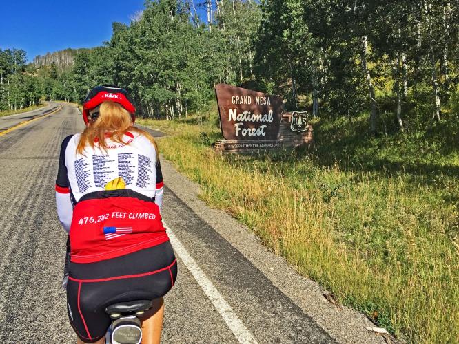
   Bike climb of Grand Mesa South - Grand Mesa National Forest sign

Enter Grand Mesa National Forest at mile 12.

Pass Ward Creek Reservoir at mile 14

Roadway Surface and Traffic Report:  For both the northern and southern approaches to the pass, the roadway is very good and while there is moderate and briskly moving traffic along the first third of the route, the traffic thins as you ascend and was never really a concern for us.

Finish at 10,839’

At the top of the climb, you can take a dirt road to the right to the Land’s End Observatory: 

“Land's End Observatory is a ranger observatory on the rim of Grand Mesa in Colorado. It is accessible from the Grand Mesa Scenic and Historic Byway via Land's End Road, which is about half paved and half gravel. . . . The observatory was built by the United States Forest Service and the Works Progress Administration in 1936-37, with some assistance from two Civilian Conservation Corps (CCC) side camps. A large viewing area outside the building provides a panoramic view of western Colorado and eastern Utah. As of 2014, the observatory building itself is closed and boarded up. . . .”
Access to full Climb Summary requires a PJAMM Cycling PRO Membership!

It takes less than a minute to sign up & with your PRO membership you can:
  • Rate climbs, post comments and share your experiences on any of our climb pages
  • Create bucket lists of climbs & mark the dates you complete them
  • Weather data for all climbs - Start & Finish
  • Upload photos to your member page to customize your PJAMM Cycling experience
  • Utilize all of our interactive tools - Profile & Routes in Area
  • Download climb route .gpx files
LEARN MORE
SIGN UP

Already have an account? LOG IN HERE