![Cycling Mt. Rose East, Nevada Cycling Mt. Rose East, Nevada - aerial panoramic photo shows Lake Tahoe, the road from Lake Tahoe, Mt. Rose Summit, and the road from Reno, snow capped mountains, blue sky]()
Cycling Mt. Rose East -- A Top 100 US Bike Climb
Ride 16.7 miles gaining 4,350’ at 5% average grade.
![Cycling Mt. Rose East, Nevada Cycling Mt. Rose East, Nevada - photo collage, road sign for State Route 431, aerial view or road to Mt. Rose, elevation sign for 8260', Mt. Rose elevation sign for 8911', Highest Year-Round Sierra Pass, snow capped mountains along two-lane roadway, PJAMM Cycling logo in corner]()
The summit is the highest pass open year round in California and is on busy State Highway 431 which connects Reno and Lake Tahoe (Incline Village).
The first seven miles of this climb are along a busy highway with uninspiring views. However, as we climb up the mountain towards the summit, the views of Mt. Rose in front (westward), the Reno plain to the east, and alpine forest surrounding us from about 7,000' are much improved. Most of the climb is mild, in the 4-7% range, although miles 11-13 average 9% grade. Cycling Tip: Start your climb at mile 7 (Galena Creek Visitor Center) and skip the worst part of Mt. Rose Highway.
![Cycling Mt. Rose East, Nevada Cycling Mt. Rose East, Nevada - road sign for Incline Village, Crystal Bay, Kings Beach, snow capped mountains beyond]()
The traditional climb starts at the beginning of Highway 431 south of Reno.
“The east side of Mount Rose Summit in western Nevada near the California border is a big hill and one of multiple routes to get to scenic Lake Tahoe. From Highway 395 the climb begins as a sometimes busy four lane road heading west along gradually increasing grade. After about four miles it reduces to two lanes and soon enters some pine trees. It is at this point that the climb begins to feel more like an alpine ascent as it starts to twist up the mountain toward the Tahoe crater rim. This section is along fairly steady grade and through a few switchbacks and contains some good views in places when the trees part or thin. Eventually the road heads inland a bit and the trees disappear within an alpine setting before you reach the summit at scenic and signed Rose Summit (8,933 feet), the highest year round pass in the Sierra Nevada Mountains. While open all year it can be quite cool on the upper section during the winter months. Keep in mind this road carries a reasonable amount of traffic most days and there is a rest area on top as well. Due to its twists and turns Rose Summit East is a superb descent through sweeping turns and somewhat challenging until the final stretch which is quite fast (but usually with traffic).” (This quote is provided with the approval of John Summerson from his book, The Complete Guide to Climbing (by Bike), 2nd Edition, pg. 192.)
![Cycling Mt. Rose East, Nevada Cycling Mt. Rose East, Nevada - road sign for Galena Creek Visitor Center]()
Cut off a lot of the worst of Highway 431 traffic by starting at Galena Creek Regional Park.
The climb from here is 9 miles gaining 2,654’ at 5.6% average grade.
![Cycling Mt. Rose East, Nevada Cycling Mt. Rose East, Nevada - photo collage, pine trees line highway, packed snow walls up to sign for Mt. Rose summit, roads lined with very tall snow, elevation 7000' sign, cyclist rides on roadway, PJAMM Cycling logo in corner]()
Since the pass is open during winter, you will ride beside snow during the colder months.
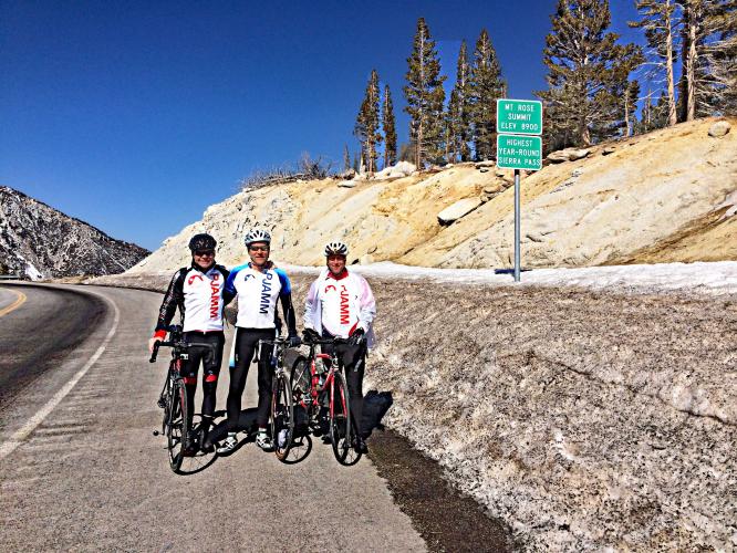
![Cycling Mt. Rose East, Nevada Cycling Mt. Rose East, Nevada - signs for Mt. Rose Summit, PJAMM Cyclist stands with bike next to NPS Sign for Mount Rose Summit Plaza, Humboldt-Toiyabe National Forests]()
Mt. Rose Summit.
![Cycling Mt. Rose East, Nevada Cycling Mt. Rose East, Nevada - Highway 431 leading to Mt. Rose summit from the east]()
These photos show Highway 431 leading to the summit from the east.
Roadway Surface and Traffic Report: The roadway surface is excellent. However, due to the heavy and fast moving traffic (see YouTube video) we do not recommend this climb. An alternate and much better route is to begin nine miles up the road at the Galena Creek Visitor Center (Map).
Mt. Rose from Lake Tahoe/Incline Village: The climb from Lake Tahoe from the west is more scenic with less traffic (map from Lake Tahoe side).

 We've partnered with Sherpa-Map.com to bring you the best route planning tool. With a PRO Membership you can use this climb as a reference when creating your route.

