15.7
PDI
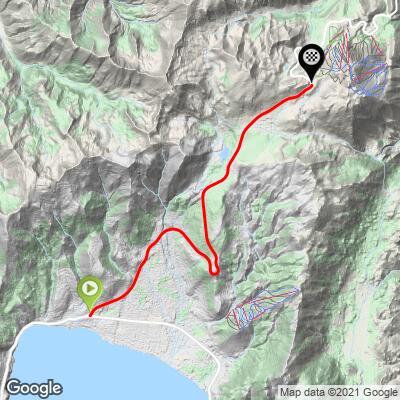
8.1 mi
DISTANCE
2,503 ft
GAINED
5.8 %
AVG. GRADE
FULL CLIMB STATS
Page Contributor(s): John Summerson, The Ultimate Guide to Climbing (by Bike) 2nd Ed.
INTRO
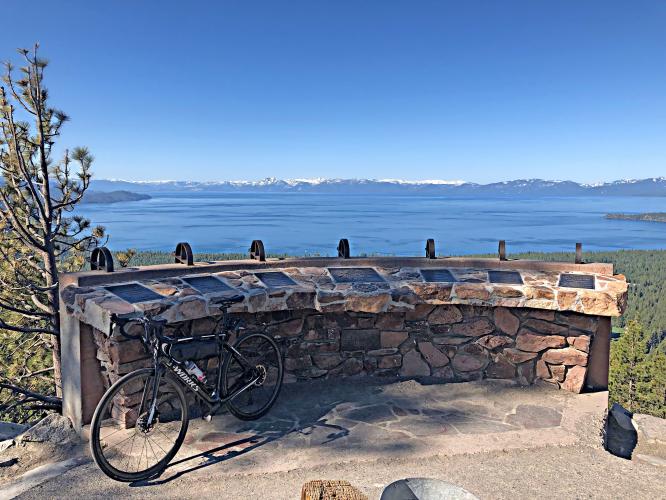
"The west side of Mount Rose is a smooth ascent over a solid grade up from scenic Lake Tahoe in western Nevada. There are excellent views of the lake in a few places on the way up. The road also carries a bit of traffic most days heading back and forth to Reno so stay alert as you ascend. There can be a bit of congestion on its lower slopes along with the majority of its traffic. Soon the houses and most signs of civilization recede and you are riding through pine forest. The grade is solid and steady throughout several sweeping turns. Near the top there is a short descent but climbing soon resumes over solid grade. The hill soon ends at signed Rose Summit in a scenic setting with views..." (This quote is presented with the approval of John Summerson, from his book, The Complete Guide to Climbing (by Bike), 2nd Edition, pg. 192.)
PLAN YOUR ROUTE
This is a good climb along a fairly consistent grade that averages 5.8%. 67% (5.4 miles) is at grade 5-10%. The steepest quarter-mile is 8.1% and steepest mile is 7.1%.
See more details and tools regarding this climb's grade via the “Profile Tool” button.
Roadway: A two lane highway that is in excellent condition.
Traffic: Moderate to heavy - this is a primary route from Lake Tahoe to Reno.
Parking: We have parked at Preston Field just east of the roundabout where the climb begins on the several times we have done this climb - Map; Street View.
This is the only pass in the Sierras that remains open during the winter, thus you can do this ride throughout the year - sadly, we have been able to do it often in the winter between 2015-2020 due to the drought in the western US. Consult the PJAMM "Full Forecast" feature for the time you expect to arrive at the finish to assess what clothing to bring on your ride.
Before heading out on any cycling adventure check out our Things to Bring on a Cycling Trip and use our interactive check list to ensure you don't forget anything.
This is one of many climbs in the Lake Tahoe area. Consult PJAMM's Lake Tahoe climb page for bike climbs around Lake Tahoe. This climb is also done as a nice out and back with Mt. Rose East - 48 miles gaining 6,705' (Map).
ROUTE MAP
MEMBER RATING
CURRENT WEATHER
PJAMM TRIPS ADVENTURE STARTER BUNDLES
Check out PJAMM Adventure's prepackaged (self-guided) cycling trips. They will help you plan, document and conquer your next adventure.
NEARBY CLIMBS (0) RADIAL PROXIMITY
FROM No Climbs Found
MEMBER REVIEWS & COMMENTS
Let us know what you thought of this climb. Signup for our FREE membership to write a review or post a comment.
Already have an account?
LOG IN HERE