![]()
Cycling Wildrose (gravel bike recommended)
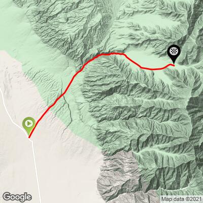
Ride 14.6 miles (paved portion) to elevation 5,808’ gaining 4,415’ at 5.7% average grade.
Looking for a cycling adventure? The Wildrose Road climb is quite a ways up there on our WOW scale. This cycling climb is best defined as "an adventure." You begin in Death Valley in a remote location that greets you with a "Road Closed" sign.
As we were getting ready to ride our road bikes up the road, a jeep came rumbling down towards us. We stopped the driver and asked what the road was like and were told "don't do this road on that bike." Well, we'd come too far to turn back so we headed on up Wildrose Canyon on road bikes (mine was a Roubaix with compact chainrings, 30t and 28mm tires).
![IMG_1554.JPG]()
Start of climb - 16 miles south of Panamint Springs on a closed Wildrose Road.

Cycling Death Valley’s Wildrose Road - the most remote US Top 100 Bike Climb.
Visit our Death Valley National Park page
![]()
Climbing out of the valley a few miles from the start.
![IMG_1556.JPG]()
There are not many view obstructions in Death Valley.
View on the beginning leg of the climb.
![]()
First segment of the climb - 9.4 miles at 5.4% to the Emigrant Canyon Road-Wildrose Road junction
![]()
A little oasis (but, no water) at mile 8
The first 9.4 miles from the start to the intersection of Wildrose/Emigrant Canyon Roads is very rough and broken pavement, but quite doable. See PJAMM’s Youtube videos of the Wildrose Climb.
![]()
Wildrose Canyon is from miles 6-9.5 (photos April, 2021)
The roadway surface from the "intersection" of Wildrose and Charcoal Kilns Road to the end of the pavement on Charcoal Kilns Rd (5.2 miles) was fresh and smooth pavement in September, 2014 (still in great shape October, 2019) when we first did this climb. You may encounter all manner of wildlife along this remote climb, from tarantulas crossing the road, wild burrows milling about on the roadway and hillsides and coyotes wandering along the desert landscape.
![]()
Carla Morton April, 2021 update: We did end up driving it…we left the charcoal kilns and then headed west on Wildrose toward Panamint Valley Road. The conditions of Wildrose are not great for road cycling. The surface was washboard in some areas. There were washouts, broken pavement, large holes and large ruts for nearly the whole length of the road. The surface a mile or so before coming to Panamint Valley Road was a coarse chip and seal.
PJAMM note: The road is probably a bit more broken up than in 2014, but it still sounds like an epic adventure - 😈. But, be absolutely certain to bring enough water with you - there are no provisions on this route and very few people travel the first 9.4 miles along Wildrose Canyon.
![]()
Herd of mules at intersection of Wildrose and Emigrant Canyon Road - mile 10
Turn right at the intersection and head east on what soon becomes Charcoal Kilns Road
![]()
Mile 9.4
Junction Wildrose-Emigrant Canyon and Charcoal Kiln Roads.
![]()
There are rollers on almost every road you will travel in Death Valley.
![]()
Left: View east towards Charcoal Kiln
Right - view west towards junction of Wildrose-Emigrant Pass-Charcoal Kiln Roads.
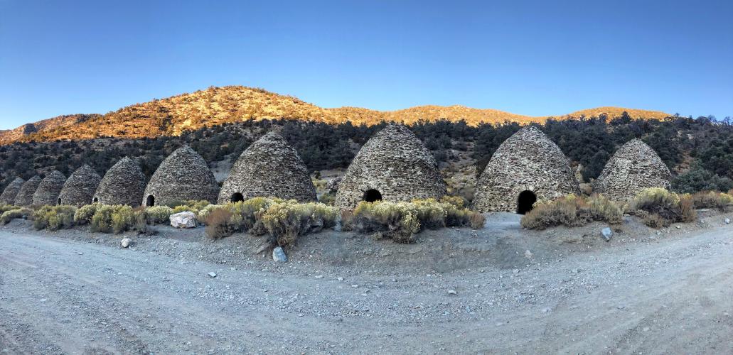
CHARCOAL KILNS
![]()
Bonus points for making the final 2.2 miles from the end of the pavement to the top of Charcoal Kilns Road which is very steep and very rocky. We made it 1 mile but ran out of daylight and had to turn back.The last 2.2 miles is at 9.9% average grade.
![]()
Death Valley - Charcoal Kilns
The kilns were built in 1877 by the Modock Mining Company as fuel for their silver smelters in the mountains west of Panamint Valley. These kilns are believed to be the best preserved of their kind in the Western US. The mines have been inactive for over 100 years, but are in excellent condition.
![]()
![]()
This rig made it up no problem.
![]()
That’s a wrap!
DEATH VALLEY WEATHER
![]()
National Park Service Death Valley Weather Chart
Dangerously hot during the day from June through September with average monthly highs during that time ranging from 106 to 116.5. Cycling is not recommended during the summer and certainly never without good SAG support. The heat can be stifling (if not truly dangerous) and supplies are few and far between - There are no provision, no water, no civilization on this ride.
The hottest temperature ever recorded on earth was in Furnace Creek on July 10, 1913 (134℉/56.7℃) and, while that record has been challenged, the “alternate” record is also held by Death Valley (2013 in a tie with Mitribah, Kuwait in 2016 at 129.2℉/54.0℃).
![]()
July 2017 - Badwater to Mt. Whitney Summit.
=========================================================================
From Dennis M’s Great Adventure and Blog[1]
Alright, this is it. When planning this trip, there were 2 climbs I really wanted to do: Wildrose to the Kilns, and Dante’s View. I knew Wildrose was going to be a challenge, because of several factors: 1) it is in the middle of nowhere, truly the exact sort of climb I wanted to target for this adventure 2) the road is closed, and it has been for some time due to washouts, land slides, deep gravel, etc. 3) the weather forecast was getting worse and worse, now looking like mid-90s.
Now add that this is the first climb of the trip, because it was “on the way” from Kernville, it was setting up to be a bit of a nervous time.
DISCLAIMER TIME: Riding a motorcycle is dangerous. Riding a bicycle is dangerous. Riding either of these in Death Valley is extra dangerous. Doing one, or both of these, ALONE in Death Valley, is not to be taken lightly. I carry enough food and water for double what I expect to encounter. I carry a certified PLB (Personal Locator Beacon) in case of true emergency, but basically I assume I’m on my own for 24+ hours. I aim to be at 50% at all times (50% of food, 50% of water, 50% of my bicycling capability, 50% of motorcycle grip, etc.) That way when I go over the limit by accident or mishap or surprise, I don’t die.
Alright, up ~2 hours before dawn, drank coffee, bicycle kit on, motorcycle kit on top of bicycle kit.. and a rather precarious 2 hour motorcycle trip in the dark to the Panamint valley side of Death Valley. This illustrated a challenge: I have not been riding my motorcycle very much and am badly out of practice. More riding required.
After a quick gas stop in Trona, the sky started getting light and the vastness of the desert opened up. Droning another 45 minutes through the middle of nowhere, brought me to the Wildrose turn off. It is literally, a turn off into nowhere.
![]()
Lower Wildrose Road, off Panamint Valley
A little bit on the “Road Closed” – road conditions can change very rapidly in Death Valley, as nearly all the roads run along natural “washes” (normally dry river/creek beds) – so any precipitation will rapidly reconfigure conditions. In this case, there had been no precipitation for a few weeks, and I had reliable reports from motorcyclists & 4x4ers about potential conditions. At worst, it sounded like a few sections of hike-a-bike.
The main risk would be lack of traffic – no one was going to rescue me if I had a mechanical or injury. But see above disclaimer, I was pretty well prepared and riding cautiously.
First observation: Changing from motorcycle to bicycle takes a lot longer than you would think. Without really rushing, I’d say it took me 20+ minutes before I was ready to roll. It’s just a lot of bits and pieces to move around, bolt together, lock together, etc.
For my longer trip, this type of ride will definitely need to be an exception vs. norm.
I was somewhat nervous leaving my motorcycle & kit.. but hey, that’s part of this trip too, can I deal with possibly coming back and having no gear or motorcycle?! I did leave a note strapped to my bike in a document holder:
“Hi, I’m off bicycling and/or hiking for a few hours. I have plenty of food, water, and a GPS emergency beacon. Please don’t mess with my motorcycle or gear, I will need it when I get back so I don’t die. Thanks. Emergency contact xxxxx.”
Okay, off to bicycle – and as expected, yeah, there was some gnar on the closed road section. Deep gravel, washouts, some mud starting around 3500 feet. This ended up using a lot more watts than I anticipated, as pedaling through deep gravel requires a fair amount of watts or you fall over and/or stop and walk. Luckily there was only one section that I couldn’t actually pedal through, so I walked maybe 100 feet.
This overall section was probably the highlight of the trip. It was interesting, it was unknown, and it was EMPTY. When you are alone in Death Valley, you are REALLY alone. I saw not a soul until reaching the intersection with Charcoal Kilns road about 3/4 up.
![]()
Halfway up Wildrose Canyon
Once past the closed section, you junction up with Charcoal Kilns Road, which takes you up to the old kilns that were used to make charcoal for the various smelters in the area.
This is more typical Death Valley – vast vistas and basically nothing.
![]()
Charcoal Kiln road about halfway up
The segment I had loaded on my Wahoo ELEMNT was from John @ PJAMM, which was labeled “2 miles past dirt” – well lemmie tell ya, that dirt was the worst. Lots of washboard, rocks and gravel. Both challenging and unfun.
Double unfortunate, that segment didn’t go all the way up. So when I was “done” – I had 20 more minutes of climbing to do, all of it from to 10-14% grade.
Eventually I made it up to the 2nd gate (the road continues further past the 2nd gate, but stuck to my plan to turn around here, given the potential heat down in the valley, etc.)
I had just finished off my 2L camelbak at this point, so I still had 2 full water bottles.
![]()
![]()
Snow 3-16-17 (left); Charcoal kilns (right)
![]()
The valley heat was not far from my mind, so I hit the descent. This was even worse going down. Heavy washboard is the one thing a rigid gravel bike is really bad at. So it was slow, riding the brakes for several miles of dirt road. Once I hit the pavement, it was 40+ mph until the turn off to the closed section. Having some experience going up, this was not as bad going down since I could float over most of the gravel sections at a reasonable speed.
Back at the bottom, air temperature was around 87F. Not too bad, but glad I didn’t hang around.
![]()
![]()
Here’s the Strava segment. Note on John’s page, this is #56 with a Fiets score of 8.64, but as noted above, I kept on going for another 20 minutes of 10-14% grade. Plotting my route on ridewithgps.com returns a Fiets score of 11.64, which would put this climb up in the Top 20 in the country. Add in the remoteness, it was no surprise I had to create a new Strava segment to cover it!
After mounting the bicycle and donning my motorcycle gear, I motorcycled the remaining 15 miles to Panamint Springs to camp overnight.
Note from Dennis M regarding his gear and the gravel section: “I was using Specialized Trigger tubeless, 700x38. The upper dirt was standard "car traffic" washboard gravel road, so going up was no problem, but the ride down was pretty miserable and bumpy. I'd have done it on 700x28 Hutchinson Sectors or similar, no problem.”
Dennis M’s Great Adventure and Blog
So there you have it. Wildrose is one of the most remote cycling climbs in the United States. Depending on how far up the road you go, it can become one of the hardest climbs in the U.S. as well. When you’re ready for an adventure, head to Wildrose in Death Valley!
[1] Reproduced with permission of author