![IMG_6775.JPG]()
Road along cliff and through tunnels - amazing segment of this climb.
Visit our Monte Grappa Home Page.
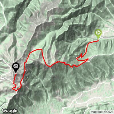
Alano is the northernmost of the eastern ascents Monte Grappa approaches (Alanao/Pedrobba/Cavaso del Tomba). As with the Pederobba ascent, we are surrounded by trees and the mountainside for the first segment of the long climb. This is one of the more “tame” of the climbs as it does not have the 20% brutal grades the the first sections of the southerly and northern ascents do. This is also the much shorter Monte Tomba route which ends at the top of the first climb at mile 4 / km 6.4 where Alano’s SP 10 merges with SP 141 from Pederobba.
![IMG_6775.JPG]()
Lovely scenery on this route
![IMG_6774.JPG]()
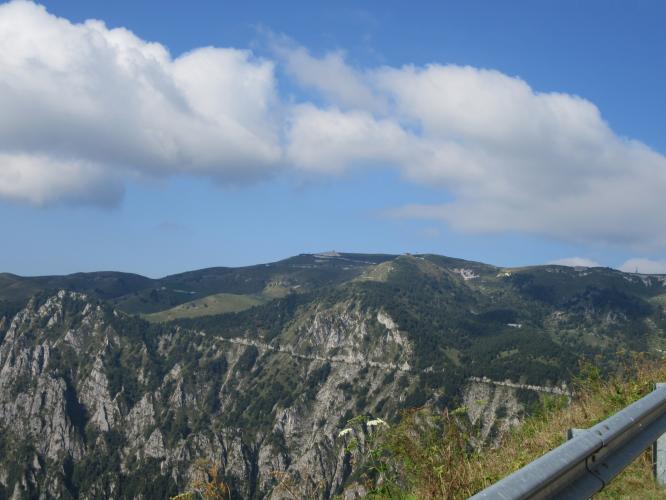
Monte Tomba - 4 miles / 6.4 km from Alano
There are magnificent views to the north as we ride out of the trees for a stretch around mile 2 / km 3.2
![IMG_6805.JPG]()
![IMG_6816.JPG]()
All 11 routes up Monte Grappa ultimately connect. At mile/km 4 / 6.4 Alano mergers with the theretofore merged Cavaso/Pederobba from the east (to our left); next the climbs to our west begin to enter from our left as we travel easterly - Possagno at 5.4/8.7, Fiettta 7.5/12, the dirt and gravel Crespano route crosses our path at Refugio Ardosetta (11.6m/18.7km; later joining from the right at mile/km 13.1/21), Semonzo at 12.4/20 and our final merge is .4 miles/.6 km from the top as we merge with the northern 3 climbs (Cismon, Caupo and Seren) and Romano d’Ezzelino.
After climbing 7 miles/11.2 km at 9.9% average grade, we enter ranch and open meadow area where we encounter a 2-part descent totaling -500’ over a 1.6 mile/2.6 km stretch.
![IMG_6872.JPG]()
First of the 2 descents starting at mile/km 7/11.2
![IMG_6876.JPG]()
End of descent #2 - old structure top left
As with all routes up Monte Grappa, there are monuments and/or remnants of WW I along this route:
![IMG_6831.JPG]()
Memorial on the way up from Alano
![IMG_6936.JPG]()
Patriots/Resistance Memorial near the top
Around mile 10.6/km 17 we encounter 4 short and old (WWI vintage) tunnels (Google Street View) which often have a group of mules in or near them. The road is very narrow and with a sheer drop off to the left as we ride for a mile/1.6 km along this segment.
![]()
Unique stretch of road on the routes from Fietta, Posagno, Cavaso del Tomba and Pederobba.
Military Road along sheer cliff to the left and through 3 short but cool tunnels.
One of the 4 tunnels around mile 10/km 16
One of 4 tunnels at mile 10 / km 16 and their frequent occupants

All 11 Monte Grappa routes end at the Rifugio Bassano a Cima Grappa which is a cafe with many outside chairs and tables and is frequented by many cyclists each day - this is a very popular Italian cycling destination. The Rifugio is just below the Sacrario del Monte Grappa which is a monumental burial site for approximately 20,000 of the Italian and Austrian soldiers who died in battle on the hillsides of Monte Grappa during World War I.
![]()
The Sacrario del Monte Grappa and la Madonna del Grappa (chapel on top of the Sacrario).

![]()
Excellent cafe at the top.
PJAMM 6 DAY 11 CLIMB MONTE GRAPPA CHALLENGE
![]()
Photos clockwise from top right: 8-27-16 Romano d’Ezzelino + Caupo;
8-28-16 Seren + Cismon; 8-29-16 Semonzo + Possagno
![]()
Photos clockwise from top right: 8-30-16 Alano + Fieta;
8-31-16 Pederobba + Cavaso del Tomba; 9-1-16 Crespano
Giro History
![]()
Steepest kilometer starts at km 9.9 (13.4%)