Encinal Canyon Road Bike Climb - PJAMM Cycling

7.5
PDI
5.1 mi
DISTANCE
1,460 ft
GAINED
5.4 %
AVG. GRADE

FULL CLIMB STATS

INTRO

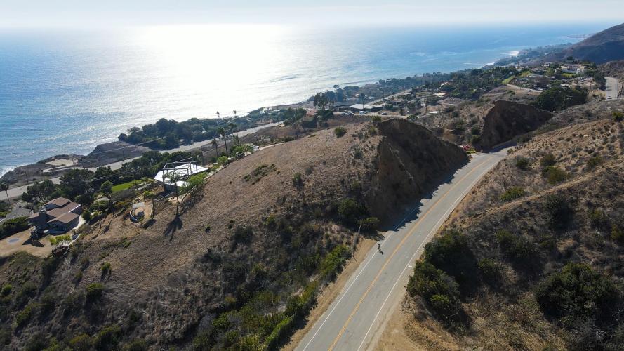
Ocean views take center stage for this climb.  The consistent gradient, length, smooth road surface, easy no-brakes descent, and beautiful views lead us to choose this road as the best road to Everest on in the world. 

We believe this so much that in October, 2021 we Everested it ourselves. Click here for our page with information to help you Everest on Encinal Canyon Road.

PLAN YOUR ROUTE

We've partnered with Sherpa-Map.com to bring you the best route planning tool. With a PRO Membership you can use this climb as a reference when creating your route.
An extremely consistent gradient which feels to never go above 6% or below 4%, besides for one slight bump about a 1/2 mile into the climb. Much milder than its neighbor Decker Canyon Road, which begins with a punchy +10% for the first 1.5 miles.
Roadway & Traffic:
Surface is very smooth. This is one of the more trafficked roads in the area and has a relatively high speed limit (50), so we recommend doing this during off-peak hours. There is a fine shoulder for most of the route and drivers in Malibu are used to cyclists.

Parking:
Ample parking right at the beginning and all along the route at any dirt pulloff that looks like a scenic viewpoint. You can also park almost anywhere along the Pacific Coast Highway and start your ride from there. 
There is a fire station with a water fountain for hikers and cyclists at the top of the climb here
Before heading out on any cycling adventure check out our Things to Bring on a Cycling Trip and use our interactive check list to ensure you don't forget anything.
There are three main hotspots to stay when traveling to Malibu: on the coast, Agoura Hills on the north side, or Santa Monica closer to the city. All of these locations are ride-in/ride-out via Mulholland Hwy or the Pacific Coast Highway. Though on the pricey side, the ultimate place to stay is the Calamigos Guest Ranch, at the intersection of Mulholland Hwy and Kanan Dume Rd: right in middle of the mountains at the top of multiple climbs, with nearly every other climb in the Santa Monica Mtns just a short ride away.

We strongly recommend coffee and pastries at Broad Street Coffee Co, and getting a craft beer and (legitimately!) world-famous lobster roll at the next door Broad Street Oyster Company.

ROUTE MAP

MEMBER RATING

Difficulty: Challenging
4
Road
4
Traffic
3.5
Scenery

CURRENT WEATHER

PJAMM TRIPS ADVENTURE STARTER BUNDLES

Check out PJAMM Adventure's prepackaged (self-guided) cycling trips. They will help you plan, document and conquer your next adventure.
ALL TRIPS
Browse all of our prepackaged trips and find your next adventure!
Malibu: Santa Monica Mountains
United States (CA)
28 ROUTES
35 POIs
ROUTE STATS (TOTAL)
359.9
mi
DISTANCE
45,284
ft
ELEV. GAIN
San Gabriel Mountains
United States (CA)
38 ROUTES
43 POIs
ROUTE STATS (TOTAL)
677.5
mi
DISTANCE
80,483
ft
ELEV. GAIN

NEARBY CLIMBS (0) RADIAL PROXIMITY

FROM
No Climbs Found

MEMBER REVIEWS & COMMENTS

Let us know what you thought of this climb. Signup for our FREE membership to write a review or post a comment.
Already have an account?

Mar 5, 2023
difficulty: Challenging
scenery: 3
traffic: 4
road: 4
Mar 5, 2023
scenery: 3
traffic: 4
road: 4
Got buzzed by motorcycles, but no big deal.
Nov 21, 2021
difficulty: Challenging
scenery: 4
traffic: 4
road: 4
Nov 21, 2021
scenery: 4
traffic: 4
road: 4
A nice way to leave PCH to get back to Mulholland. Wide shoulder, smooth road, little traffic on a Saturday at 10 am. Not the most scenic, but a very manageable gradient.
ROUTE MAP
PROFILE TOOL
Route Data
S.G. (%)
hide
Segment Data
hide
CLIMB SUMMARY

Cycling Encinal Canyon Road

Ride 4.9 miles gaining 1,420’ at 5.5% average grade.

Encinal Canyon is a very scenic bike climb with wonderful views of the Pacific Ocean as we climb northerly up the canyon away from the Pacific Ocean and PCH.

Climb begins in Malibu by riding up Encinal Canyon Road from Pacific Coast Highway.

This climb has a consistent grade that rarely strays beyond the bounds of 4-7% - the steepest ½ mile segment is 6.7%.

Photos along the first quarter mile of the ride.

The Pacific Ocean and Encinal Bluffs are to our left.

Views along the first one half of the climb.

Charmlee Wilderness Park - “Located on over 532 acres within the best of the Santa Monica Mountains Coastal Slope Environment, the park includes over eight miles of hiking trails, picnic areas, native plants, and a nature center.”  

Finish

That’s a wrap!!