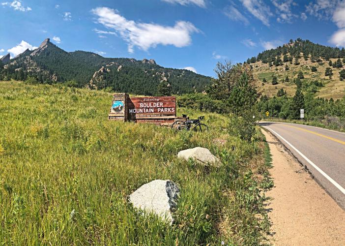
![Cycling Super Duper Flag, Boulder, Colorado Cycling Super Duper Flag, Boulder, Colorado - two-lane road surrounded by evergreen covered hillsides, road sign reminding cyclists to ride Single File on Flagstaff, wooden sign for Boulder Mountain Parks]()
Cycling Super Duper Flagstaff Road (as it is referred to on Strava).
5.5 miles gaining 2,162’ to elevation 7,831’ at 7.3% average grade.
The Flagstaff Road climb, along with its longer segment, Super Duper Flag, is the most popular bike climb in the extremely popular cycling area of Boulder, Colorado.
![Cycling Super Duper Flag, Boulder, Colorado Cycling Super Duper Flag, Boulder, Colorado - photo collage, PJAMM Cycling logo in corner, road signs for Flagstaff Road, Gregory Lane, bike leaning against road signs]()
REI’s Cycling Blog rates Boulder The Most Bikeable City in the US:
“Of course, Boulder took the top spot. The Colorado college town is basically a realistic version of Utopia—and as a result, is the subject of many tropes about yoga, health food stores, alternative medicine, breweries, college students, and now bicycling. But this shouldn’t take away from the city’s true effort to get more people on bikes. With a population exceeding 107,000, Boulder boasts more than 300 miles of designated bike lanes that connect riders to even more mileage on roads and dirt trails. For those without a bike, some 300 cruisers are available to rent for $8 for 24 hours at 47 kiosks around town. The best bike city in the United States even has a vending machine for cyclists to buy accessories at any hour of the day” (Read more here).
![Cycling Super Duper Flag, Boulder, Colorado Cycling Super Duper Flag, Boulder, Colorado - photo collage, PJAMM Cycling logo in corner, road signs for Euclid Road, Boulder Mountain Parks, reminding cyclists to ride single file on Flagstaff]()
From the Colorado Daily’s 5 Classic Boulder Road Rides August 25, 2014 article:
“Breathtaking views of the Flatirons mark this iconic Boulder climb, where the pros battled it out for a stage win in the 2013 USA Pro Cycling Challenge. Through November, Flagstaff Road is closed to cars and cyclists from 8:30 a.m. to 3:30 p.m. Mondays through Fridays, so save this ride for evenings and weekends.
![Cycling Super Duper Flag, Boulder, Colorado Cycling Super Duper Flag, Boulder, Colorado - photo collage, PJAMM Cycling logo in corner, PJAMM Cycling SAG van on roadway, climb gradient profile and map, bike parked against large stone overlooking mountainside, bike parked against sign reading "Leaving City of Boulder Open Space & Mountain Parks," sign along roadside for Realization Point of Flagstaff Summit]()
Route: From the intersection of Broadway and Baseline Road, head west on Baseline towards the foothills. The 1.3-mile false flat up Baseline is a grind, but the real climb starts at the intersection with Gregory Canyon Road. You'll get a break at the traffic light controlling a short section of road that's one-way. Then, keep an eye out for the Flagstaff House — the climb gets easier after that. Pedal, pedal, pedal until you reach the amphitheater road. Now you get some dessert after eating all your vegetables — tuck in for one of the best descents in Boulder.
![Cycling Super Duper Flag, Boulder, Colorado Cycling Super Duper Flag, Boulder, Colorado - photo collage, PJAMM Cycling logo in corner, wooden sign for Panorama Point, bike parked against low fence at Panorama Point overlooking city of boulder]()
Panorama Point offers spectacular views of Boulder.
For the hardcore, the "Super Flag" version of this ride goes past the amphitheater up to the set of mailboxes at the top, at around 8,000 feet. It's "only" another two miles, but the majority of it averages a more-than 10 percent gradient” (Colorado Daily).
![Cycling Super Duper Flag, Boulder, Colorado Cycling Super Duper Flag, Boulder, Colorado - PJAMM Cycling logo in corner, bike leaning against low wooden fence and informational sign at Lost Gulch Overlook]()
Lost Gulch Overlook -- mile 3.8.
![Cycling Super Duper Flag, Boulder, Colorado Cycling Super Duper Flag, Boulder, Colorado - close up of decal on PJAMM Cycling SAG vehicle, cyclist riding on roadway next to van]()
Finish of the popular Super Duper Flag.
Boasting in the Top 20, Lachlan Morton and Peter Stetina.

 We've partnered with Sherpa-Map.com to bring you the best route planning tool. With a PRO Membership you can use this climb as a reference when creating your route.

