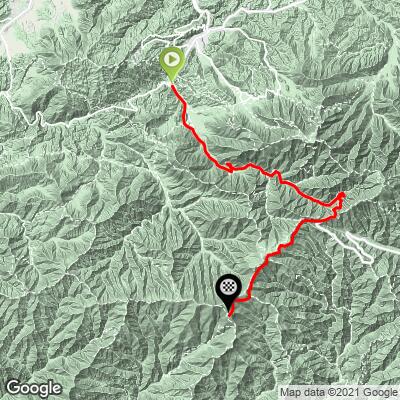
Clingmans Dome Bike Climb - PJAMM Cycling

7.4
FIETS
20.2 mi
DISTANCE
4,936 ft
GAINED
4.5 %
AVG. GRADE

FULL CLIMB STATS

Page Contributor(s): Dan Razum, Campbell, CA, U.S.A Ron Hawks, Las Vegas, NV, U.S.A

INTRO

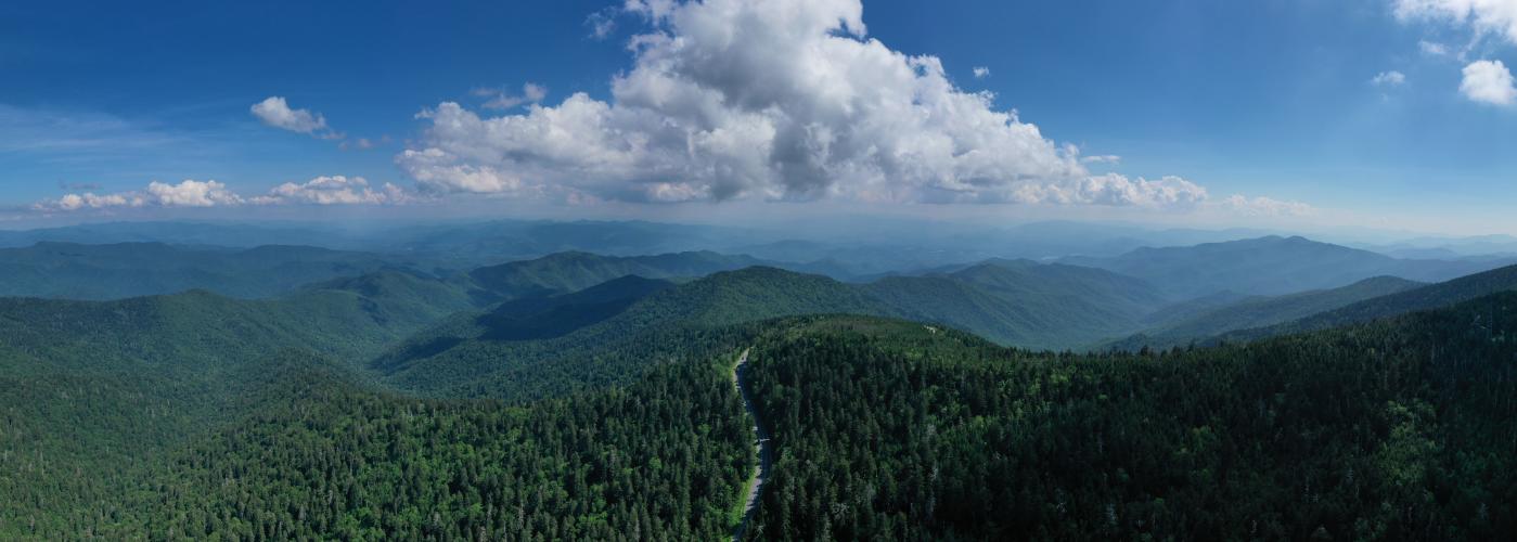
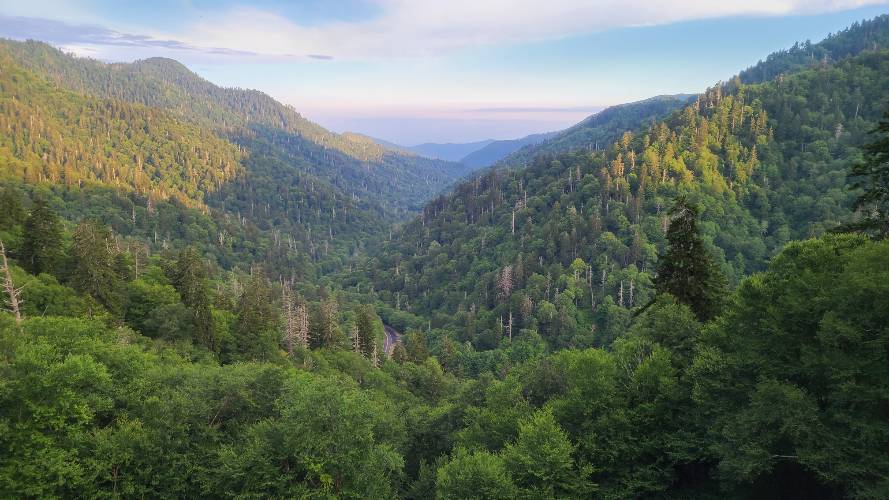
Cycling Clingmans Dome - this bike climb is, along with Mt. Mitchell in North Carolina, one of the two most popular bicycle climbs in the southeast.  The most interesting details of this climb are: (a) it is in Smoky Mountains National Park, (b) we cross over the Tennessee-North Carolina border along the climb, and (c) Clingman's Dome itself, which is a 360 degree viewpoint at the highest point in Tennessee with views of the Smoky Mountains of Tennessee and North Carolina.
Average grade is 4.4% (4.9% climb only).  5% of the climb is descent, 44% 0-5% grade and 51% is at 5-10%.  The grade over this entire climb is consistently between 3-6%, rarely straying from those parameters.  There is a one-mile -3.9% descent beginning at mile 16.9.  Removing the descent from the grade calculation raises the average climb gradient from 4.4 to 4.9%.  There are no parts of the climb at ≥10%.   The steepest quarter mile is 7.5%. 

See more details and tools regarding this climb's grade via the “Profile Tool” button.
Roadway:  Excellent. Conditions can be found here. A 2021 climb review says the road is closed Dec. 1 - March 31

Traffic:  Heavy - this is the worst part of the climb.  The first 13 miles of the climb to Newfound Gap along Highway 441 has zero to minimal shoulder and as heavy a flow of traffic as you will ever find in any National Park (The Great Smoky Mountains NP is by far the most visited National Park in the US).  However, traffic dies down once we turn onto Clingmans Dome Road for the final seven miles of the climb (which includes the one mile descent).

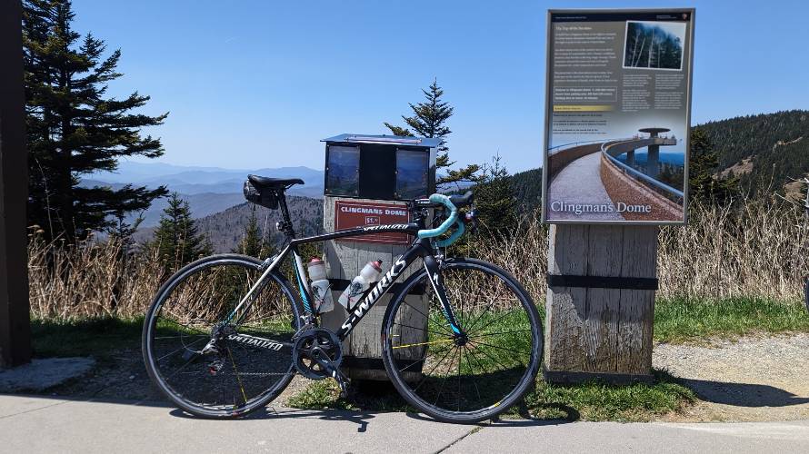
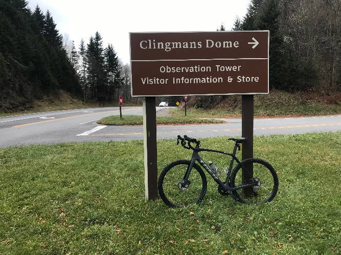
Parking:  Start as close to sunrise as you can and park at the Sugarland Visitor Center which is where the climb begins - MapStreet View.

Fee:  None - Over 12,500,000 people visit Smoky Mountains NP for free each year.
Provisions:  There are no provisions on this climb. 

Gear:  Consult the PJAMM "Full Forecast" feature for the time you expect to arrive at the finish to assess what clothing to bring on your ride.
Before heading out on any cycling adventure check out our Things to Bring on a Cycling Trip and use our interactive check list to ensure you don't forget anything.
On both our trips to climb Clingmans Dome we stayed in Gatlinburg, which is quite the tourist town.  There are many fun things to do in Gatlinburg - Trip Advisor Top Gatlinburg Attractions.  There are several hotel options around Gatlinburg and it is also popular to rent a cabin in the area.

For information on other bike climbs in the area see our The Great Smoky Mountains National Park page.

ROUTE MAP

MEMBER RATING

Difficulty: Strenuous
4.7
Road
2.4
Traffic
4.3
Scenery

CURRENT WEATHER

PJAMM TRIPS ADVENTURE STARTER BUNDLES

Check out PJAMM Adventure's prepackaged (self-guided) cycling trips. They will help you plan, document and conquer your next adventure.
ALL TRIPS
Browse all of our prepackaged trips and find your next adventure!
Smoky Mountain National Park
United States (NC,TN)
17 ROUTES
31 POIs
ROUTE STATS (TOTAL)
181.8
mi
DISTANCE
34,253
ft
ELEV. GAIN
The Blue Ridge Parkway (North)
United States (NC,TN,VA)
38 ROUTES
70 POIs
ROUTE STATS (TOTAL)
716.5
mi
DISTANCE
75,697
ft
ELEV. GAIN
The Blue Ridge Parkway (South)
United States (NC,TN,VA)
30 ROUTES
63 POIs
ROUTE STATS (TOTAL)
690.7
mi
DISTANCE
74,180
ft
ELEV. GAIN

NEARBY CLIMBS (0) RADIAL PROXIMITY

FROM
No Climbs Found

MEMBER REVIEWS & COMMENTS

Let us know what you thought of this climb. Signup for our FREE membership to write a review or post a comment.
Already have an account?

Jun 1, 2023
difficulty: Strenuous
scenery: 4
traffic: 3
road: 5
Jun 1, 2023
scenery: 4
traffic: 3
road: 5
Completed the ride on a weekday in late May, starting in Gatlinburg and following 441. I set out early (before 6:30 am) and it was absolutely the right call for two reasons. First, there was limited car traffic on my climb. And second, I reached the summit before the rangers were out and thus could ride up the tower (the steepest part of the climb!). I agree with others - bring all the water and food you need, enjoy the scenery, be sure to bring lights (front and back). I'd do it again, but only with an early departure. By the time I descended, the road traffic was steady. I also ride with both a mirror and a radar, and they helped quite a bit.
Nov 6, 2022
difficulty: Strenuous
scenery: 5
traffic: 2
road: 5
Nov 6, 2022
scenery: 5
traffic: 2
road: 5
I completed this climb last week (10/29/22) and it was phenomenal and hard. Ive only been back to cycling for a year now and viewed that as the final stamp of my first season back in the saddle and it didn't disappoint. Started from Sugarland Visitor Center at 8:00AM and, as stated by others, traffic is steady the entire way up until Mile 13 but, fortunately, I did not have any close calls. One you get off 441 and onto the Clingman's Dome access road, traffic subsides significantly. Pavement is flawless the entire way. And, my goodness, that descent was just *chef's kiss* - beyond perfection. 30-40mph the entire way for 20 or so miles? Absolutely stunning. Some tips: 1.) Take your time, enjoy the scenery 2.) Bring LOTS of water as there is no potable water on the ride once you leave the visitor center. 3.) Be sure to be well fueled. 4.) Bring multiple layers. Weather can change drastically and quickly. 5.) ENJOY!
Jul 5, 2022
difficulty: Challenging
scenery: 5
traffic: 4
road: 5
Jul 5, 2022
scenery: 5
traffic: 4
road: 5
I did the Clingman's Dome ascent twice while staying near Gatlinburg for a family vacation. First time was foggy as hec, but the second time (uploaded photos) was clear. I believe rangers at the park will prohibit cyclists from riding from the parking lot up to the observation tower ramp, but I was able to do so as I arrived before the ranger did. It is a steeper grade (8-10%?) than the road ascent (5%?). I rate traffic as "some" only b/c I began my ascent at the Sugarlands Visitor Center at dawn before the park gets busy. I counted about 30 cars passing me on the way up and 3 on the way down. Traffic gets heavy as the day goes on and no road shoulder exists but for vista pulloffs. I would certainly recommend starting the ascent as early as possible. Overall, I really like the climb and the descent was really enjoyable as the road is a moderate grade and was in perfect shape. Clingman's Dome Road itself (the final 7 miles of the climb) was just recently repaved as of late June 2022).
Jun 14, 2022
difficulty: Strenuous
scenery: 4
traffic: 2
road: 5
Jun 14, 2022
scenery: 4
traffic: 2
road: 5
Great climb and Pavement was perfect the whole way up ! You will encounter many cars even if attempted in the morning but all gave me more than enough space , some even encouraged me on towards the top! I recommend starting the climb with two completely filled bottles because there is no where to fill back up until you come back down. If you want to ride to the observatory circle , be ready for 10-15% pitches to the top. Goodluck!
Nov 22, 2021
difficulty: Strenuous
scenery: 4
traffic: 2
road: 3
Nov 22, 2021
scenery: 4
traffic: 2
road: 3
Traffic was constant. It was expected, being a Sunday. Campers being towed presented the most danger on the climb up. Started out cold and the descent off of Clingmans was fridgid. Beautiful views at each pullout. Fresh pavement up high on 441 was great. The dirt shoulder was not. Clingmans felt like riding in a National Park. Minimal traffic, beautiful sights, smells, & sounds. A must do for any Vols!
Nov 17, 2021
difficulty: Challenging
scenery: 4
traffic: 2
road: 5
Nov 17, 2021
scenery: 4
traffic: 2
road: 5
Be aware the Clingman's Dome road is closed Dec. 1 - March 31. I did not know or think about that and got lucky while riding on Nov. 16. Traffic was heavy and dangerous. Had two very close calls. Could not tell if the first (very close) was a deliberate buzz or an inattentive driver. The second, pickup truck, tried to put his hood under my left elbow but braked as I threw my arm out. The worst was the 13 miles on 441 which goes over the mountain. Once on Clingman's Dome access road all traffic was respectful those seven miles. Reached the summit and was socked in. Visibility was about 50 meters at best. The effort wasn't strenuous as much as it was just a slog. Unlike most climbs I have done and can't wait to repeat, I have no plans to repeat this one and could not recommend it because of the traffic. My ride was uphill, one-way. I did not get to experience what surely must be the best part - the descent. Maybe I will ride it again the downhill portion. Be careful my friends.
Mar 9, 2021
difficulty: Strenuous
scenery: 4
traffic: 2
road: 5
Mar 9, 2021
scenery: 4
traffic: 2
road: 5
Get started early to avoid traffic. We started at 8am and the visitor center parking was empty. By the time we got back down at 11:30am the lot was overflowing with cars. Tough climb but not overwhelming and an amazing view at the top. Pristine road leads to an amazingly fast and safe feeling descent.
ROUTE MAP
PROFILE TOOL
Route Data
S.G. (%)
hide
Segment Data
hide

Climb Profile Not Found
CLIMB SUMMARY

Cycling Clingmans Dome, Tennessee - panoramic views of Clingmans Dome, Great Smoky Mountains

Cycling Clingmans Dome, the highest peak in the Great Smoky Mountains and Appalachian Trail.

Ride 20.2 miles gaining 4,932’ at 4.4% average grade.


Climb summary by PJAMM’s John Johnson.

Clingman’s Dome, located in Great Smoky Mountains National Park, is a mountain in the Great Smoky Mountain subrange of the Appalachian Mountain Range.

Before heading to the Great Smoky Mountains on your cycling adventure, be sure to rely on our list of Things to Bring on a Cycling Trip, and use our interactive checklist to ensure you don't forget anything.

Cycling Clingmans Dome, Tennessee - photo collage, signs for Great Smoky Mountains National Park, Appalachian Trail, Clingmans Dome, North Carolina and Tennessee State Line, PJAMM Cycling jerseys draped over railing on the way up to Clingmans Dome Observation Tower, PJAMM Cycling logo in corner

This is a great bike climb through beautiful scenery that only gets better the higher you go.  The start of the climb is conveniently located at the Sugarland Visitor Center in Great Smoky Mountains National Park, where there is no entrance fee.  

Why no entrance fee to enter a National Park? According to the Great Smoky Mountains National Park website, the land that now makes up this gorgeous National Park was once privately owned.  Tennessee, North Carolina, and local communities from both states paid to construct route 441/Newfound Gap Road, and this road was a major route crossing the southern Appalachian Mountains at the time.  It was important to authorities to maintain free and easy interstate transportation for local citizens, so, when Tennessee transferred ownership of the road to the federal government for the National Park, it stipulated that “no toll or license fee shall ever be imposed” on those traveling this road.  Hence, no entrance fee to this national park! (Great Smoky Mountains NP).

Cycling Clingmans Dome, Tennessee - bike parked in front of NPS sign for Great Smoky Mountains National Park and in front of Sugarlands Visitor Center, PJAMM Cycling logo in corner

The climb starts at a nice 3% grade for the first few miles before hitting 7% and staying between 4% and 8% for the next 15 miles.

Cycling Clingmans Dome, Tennessee - photo collage, bike parked in front of various scenic mountainous locations along first half of climb, dense foliage and greenery, mountain range in background, PJAMM Cycling logo in corner

Scenery along the first half of the climb.

Cycling Clingmans Dome, Tennessee - cyclist riding into two tunnels along climb, PJAMM Cycling logo in corner

There are two tunnels -- one is about 30 meters long and we do recommend a tail light for this brief tunnel.

Tunnels during the Fall colors

Cycling Clingmans Dome, Tennessee - photo collage, sign warning to use low gear, curve in road near stone retaining wall, stone wall covered in ice, PJAMM Cycling logo in corner

Mile 11

Center bottom photo -- beware the weather at the beginning and end of the season.

Cycling Clingmans Dome, Tennessee - photo collage, bike parked in front of various NPS signs throughout Great Smoky Mountains National Park, PJAMM Cycling logo in corner

Great Signage throughout the park.  It’s not easy to get lost!

“Perhaps the most difficult SE climb, the west side of Clingmans Dome is also a scenic ascent that does carry a lot of traffic.  At mile 13 you enter NC and soon after turn right to finish at the parking area for Clingmans Dome.” (This quote is presented with the approval of John Summerson, from his book, The Complete Guide to Climbing (by Bike) in the Southeast, pg. 106.)

VIEWPOINTS AND HISTORICAL STOPS ALONG THE CLIMB

CHIMNEY TOP OVERLOOK

Cycling Clingmans Dome, Tennessee - bike parked in front of informational signs overlooking Chimney Top Overlook

Mile 5.4 / 2,970’.

MORTON OVERLOOK

Cycling Clingmans Dome, Tennessee - more informational signs at Chimney Top Overlook

Mile 12.2 / 4,840’.

NEWFOUND GAP

Cycling Clingmans Dome, Tennessee - Newfound Gap

Mile 13 / 5,046’.

Cycling Clingmans Dome, Tennessee - informational signs at Newfound Gap

Cycling Clingmans Dome, Tennessee - bike parked next to sign for North Caroline Tennessee State Line, Elevation 5046 

This is also the North Carolina-Tennessee border. 

INDIAN GAP ROAD

Cycling Clingmans Dome, Tennessee - informational signs at Indian Gap Road

Mile 14.4 / 5,265’.

Cycling Clingmans Dome, Tennessee - climb map, PJAMM Cycling jersey draped over rock about two miles from top of climb

About two miles from the top.

FINISH AND THE OBSERVATION TOWER

Cycling Clingmans Dome, Tennessee - photo collage, tourists and hikers walking along trail toward Clingmans Dome Observation Tower, bike parked against sign for tower, PJAMM Cycling logo in corner

End of the cycling road.

Cycling Clingmans Dome, Tennessee - informational signs on the way to the observation tower

At 6,643’, Clingman’s Dome is the highest point in Great Smoky Mountains National park, the highest point in Tennessee, and the third highest mountain east of the Mississippi (National Park Website).

File:Philippines road sign R3-4.svg - Wikimedia CommonsNote that riding your bike on the footpath to the observation tower is prohibited.File:Philippines road sign R3-4.svg - Wikimedia Commons

Cycling Clingmans Dome, Tennessee - aerial view of Clingmans Dome Observation Tower

Footpath leading to Clingmans Dome observation tower

Photo: Roots Rated

Clingmans Dome Observation Tower, constructed in 1959, is a 45-foot tower connected to a 375-foot sweeping ramp which visitors ascend to reach the tower’s observation deck.  Atop the deck, visitors are rewarded with 360-degree panoramic views from the highest point in the Great Smoky Mountains.  The tower itself is listed on the National Register of Historic Places, and is a major example of the National Park Service Modern architecture period.  The tower also represents the NPS’ Mission 66 program (1955-1966), which resulted in “a significant change in National Park Service planning, management, and architecture” and oversaw the construction of hundreds of buildings and structures, including nine towers.  Clingmans Dome Observation Tower served as a model for two later Mission 66 towers: Look Rock Tower (also in Great Smoky Mountains NP), and Shark Valley Tower (Everglades NP, Florida) (Clingmans Dome Observation Tower).

Cycling Clingmans Dome, Tennessee - photo collage, Clingmans Dome Observation Tower, PJAMM Cycling logo in corner

I walked my bike up and down the path without any objection . . .

more curiosity than anything from viewpoint hikers.

We are permitted to ride to the parking lot at the end of Clingmans Dome Road, but not the 0.5 miles from the Clingman’s Dome observation tower.  There is a bike stand to lock the bike at if you bring a cable and lock with you.  Otherwise, you will probably be ok walking your bike round trip from the parking lot to the observation tower.  

FALL COLORS

Clingmans Dome has spectacular fall colors.

Word of warning/advice - it is ridiculously busy during the leaf peeping (fall colors) season.  Of course, this is also a wonderful time to ride your bike to Clingmans Dome as you can stop wherever you like which gives you a significant advantage over vehicles.  We began our ride in early October on a weekday at 8 a.m. and it was already crowded, but it go much more crowded a couple hours later.

One alternative to beating the traffic is to begin you climb to Clingmans Dome from the Cherokee, North Carolina side.  Although there is also significant traffic on that side, it is about a third to one-half less than on the Gatlinburg side.

The National Park Climgman’s Dome page advises:

Pets and bicycles are not permitted on the paved trail to the observation tower, or on any other trails in the area. A bike rack is located near the beginning of the paved trail to park bikes while walking to the top. You will need to bring a lock with you to secure your bike (More).

Ride summary by Dan Razum of Campbell, California:

The route is straightforward with the first 13 miles are on route 441.  This section is on beautiful pavement but carries a lot of traffic with no shoulder.  For perspective, I did this climb in early May on a weekday and was passed by a car every couple of minutes.  If you do this in the summer on a weekend, the traffic will make it almost impossible to enjoy this ride safely.  After 13 miles on 441, turn right for Clingmans Dome for the next seven miles which will take you all the way to the top. These seven miles, which are also on great pavement, give you beautiful views of the park and carry about half as much traffic as route 441.  Around mile 17.5, you will get a mile stretch that is flat-to-down, giving you a nice reprieve before tackling the final stretch of this climb.


The top of Clingmans Dome has a large parking lot where visitors take a half-mile trail to the circular dome that offers 360 degree views of all the surrounding mountain ranges.  Please note this last half-mile is a 10 foot wide walking path that has lots of people coming and going.  Although I didn't see a sign that specifically said no bikes, the ranger said it isn't allowed as it would be impossible and downright unsafe to do this with all the foot traffic.  If you want to do this last stretch, which is very steep (around 14%), you would need to do it very early in the morning or right before sunset.

Steepest quarter mile begins at mile 20.2 (13.5%) and mile at 19.8 (8.1%).

Clingmans Dome view point at the top of the bike climb at sunset

View from Clingman’s Dome at sunset.

Cycling Clingmans Dome, Tennessee - sunrise over the Great Smoky Mountains as seen from Clingmans Dome

Sunrise from Clingman’s Dome.

That’s a wrap!