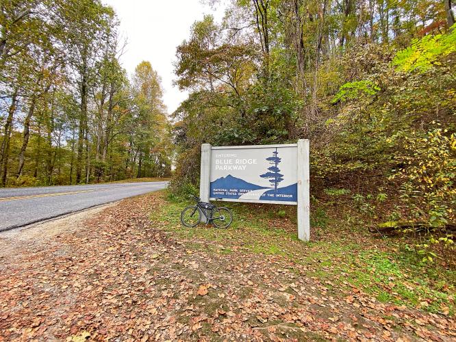
Cycling Blue Ridge Parkway -- Cherokee Hill
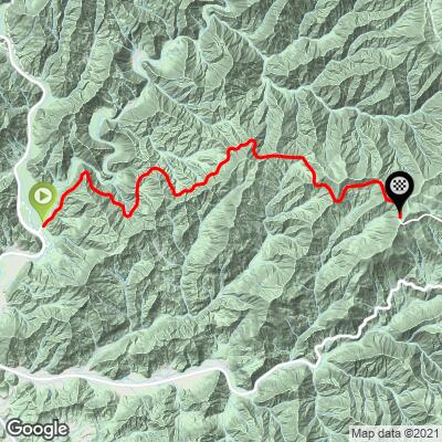
Ride 10.3 miles gaining 3,133’ at 5.5% average grade.
This climb starts at the beginning of the incomparable Blue Ridge Parkway. The BRP is America’s longest linear park and runs 469 miles through North Carolina and Virginia. A trademark of the BRP is its 200+ beautiful overlooks -- more than any other roadway in the US.

This climb is the southern start of the Blue Ridge Parkway.
![]()
Map of the BRP, from Virtual Blue Ridge
As can be seen from the map above, Cherokee, North Carolina is at mile 469 of the Blue Ridge Parkway. Depending on which way you start from, this area is the beginning or end of this famous and iconic roadway. The website for the Blue Ridge Parkway writes, “at the southern entrance/exit to the Blue Ridge Parkway, Cherokee, North Carolina is home of the Eastern Band of Cherokee Indians. You’ll find museums, cultural and family attractions, motels, campgrounds, restaurants, shops, the famous outdoor drama “Unto These Hills,” and Harrah’s Cherokee Casino…” (Blue Ridge Parkway). You can also check out more information on things to do in Cherokee, the gateway of both the Blue Ridge Parkway and Great Smoky Mountains National Park, here.

PJAMM Adventure App shows stats at climb start.
This is a tough climb with several short segments in the double digit gradients. The steepest quarter mile is 12.3%.
FIVE TUNNELS ON THE CLIMB

John Sommerson writes of this climb:
“The very beginning (or end) of the Blue Ridge Parkway, Cherokee Hill is very scenic and heads through multiple (5) tunnels along its route, ending at an unmarked summit just beyond its fifth tunnel. It is rated the most difficult individual Parkway climb.” (This quote used with the approval of John Summerson, from his book, The Complete Guide to Climbing (by Bike) in the Southeast pg. 99).
BLUE RIDGE PARKWAY OVERLOOKS
We photographed each parkway overlook that had signs -- several signs were missing at the time of our ride. The photographs are by PJAMM Cycling, while the quotes are from the exceptional and informative website Virtual Blue Ridge.

Oconaluftee River Overlook -- Mile 0.6.
“View Oconaluftee River, Milepost 468.4 - Elevation: 2200': A Cherokee village once stood a few miles down river called “e-gwan-ul-ti” meaning “by the river.” After time, the pronunciation led to its current name,” (Virtual Blue Ridge).

Raven Fork Overlook -- Mile 1.
“View Raven Fork, Milepost 467.9 - Elevation: 2400'. Raven Fork enters the Oconaluftee River a mile downstream. The river bed was once used as a crossing known as Ravensford,” (Virtual Blue Ridge).

Ballhoot Scar Overlook -- Mile 1.6.
“View Ballhoot Scar, Milepost 467.4 - Elevation: 2550'. Motorists stop along this overlook to absorb all of the brilliant Fall colors. The slashes down Ballhoot Scar are remnants of the paths trees took on their way to the sawmill. The men would yell “ballhoot” as a warning before the trees tumbled down the mountain,” (Virtual Blue Ridge).

Thomas Divide Overlook -- Mile 5.
“Thomas Divide Overlook, Milepost 463.9 - Elevation: 3735',” (Virtual Blue Ridge).

Jenkins Ridge Overlook -- mile 8.1.
“Jenkins Ridge Overlook, Milepost 460.8 - Elevation: 4445'. Another settler that was able to get along with the Cherokees was Jonas Jenkins who lived on the far side of the large ridge visible to the left,” (Virtual Blue Ridge).

Lickstone Ridge Overlook -- Mile 10, climb’s finish.
“Lickstone Ridge Overlook, Milepost 458.9 - Elevation: 5150'. The Lickstone Ridge tunnel here is 406-feet long. A lickstone was a smooth stone where settlers would spread salt for their livestock,” (Virtual Blue Ridge).
This climb finishes at Lickstone Ridge Overlook, just before Lickstone Tunnel.

Tunnel just past the finish.