![Cottonwood Pass - Continental Divide Bike climb to Cottonwood Pass - Continental Divide sign.]()
Cycling Cottonwood Pass: One of the US 100 Bike Climbs that reach the Continental Divide.
Ride 19.2 miles gaining 4,320’ to elevation 12,126’ at 4.1% average grade.
“A long and solid climb, Cottonwood in central Colorado ends as one of the highest alpine passes (12,126 ft) in the United States. Down low you follow a creek and the grade is quite shallow and within a canyon. Soon you climb a ridge as aspens and some elegant curves accompany you up the hill. A few sections are over more solid grade (a short stretch is double digit) and the road gets to the very top through a big switchback. At the signed summit the road turns to dirt. There are big views on top (and some good hiking) as it is surrounded by some of the biggest mountains in the state (closed in winter - San Isabel National Forest - 719-539-3591).” (This quote is presented with the approval of John Summerson, from his book, The Complete Guide to Climbing (by Bike), 2nd Edition, pg. 172.)
Before heading to Colorado on your cycling adventure, be sure to rely on our list of Things to Bring on a Cycling Trip, and use our interactive checklist to ensure you don't forget anything.
![Cycling Cottonwood Pass, Colorado Cycling Cottonwood Pass, Colorado - photo collage, PJAMM Cycling logo in corner, bike parked next to old wooden shack in green pasture, PJAMM Cycling jersey laying on rock in front of sign for Holy Water, bike parked next to NPS sign for San Isabel National Forest, bike parked next to road sign for curve in road, aerial view of large U-shaped curve in road]()
Cottonwood Pass (East) is one of only six climbs in the U.S. that top out above 12,000' (five of those six are in Colorado -- the Himalayas of North America). This is also one of only three of the thirteen Colorado Top 100 U.S. Climbs that ends at the Continental Divide (Independence Pass and Wolf Creek Pass are the other two).
![Cycling Cottonwood Pass, Colorado Cycling Cottonwood Pass, Colorado - PJAMM Cycling logo in corner, bike parked next to road signs for Cottonwood Pass, Cottonwood Lake, N Cottonwood Circle, Cottonwood Pass Open]()
Cottonwood “Pass” is the highest paved actual pass in the US at 12,126’ (Independence Pass is a close second at 12,095)’. Each of Mt. Evans, Pikes Peak, and Mauna Kea are higher, but end at the top. Until September 2019, Independence Pass held top honors as Highest US Paved Pass, because Cottonwood Pass was not paved on its back side. Trail Ridge is slightly higher, but its high point is not marked as a “pass” (Iceberg Pass is down from the Trail Ridge high point at 11,827’). Thus, as of its paving in September 2019, Cottonwood Pass claims the prize for highest paved pass in the US.
![Cycling Cottonwood Pass, Colorado Cycling Cottonwood Pass, Colorado - aerial view of Cottonwood Pass & Continental Divide, showing hairpin leading to the top of climb]()
Cottonwood Pass & Continental Divide -- photo bottom center
Loop and hairpin leading to the top bottom center left of photo.
![]()
View of the pass and roadway leading to the finish.
Cottonwood Pass is in the Sawatch Mountains Range of central Colorado and is part of the Rocky Mountains. Eight of the 20 highest peaks in the Rocky Mountains are in the Sawatch Mountains.[1]
![Cycling Cottonwood Pass, Colorado Cycling Cottonwood Pass, Colorado - photo collage, PJAMM Cycling logo in corner, bike parked at Comanche Drive-in movie theatre, sign showing theatre is playing Gremlins August 6-8]()
Pass Comanche Drive-In Theater (open for business!) within the first mile of the climb.
This spectacular climb begins at the western edge of yet another quaint Colorado town, Buena Vista. We are actually travelling a County Road on this one (Chaffee County road 306), beginning at elevation 8,016 and riding to an oxygen sucking 12,126’.
![Cycling Cottonwood Pass, Colorado Cycling Cottonwood Pass, Colorado - photo collage, PJAMM Cycling logo in corner, bike parked at various spots along the beginning of the climb, next to road signs, on bridges, PJAMM Cycling's white SAG van parked next to bike route road sign]()
Climb begins in Buena Vista by riding West on E. Main Street from its intersection with Highway 24
Buena Vista (pop. 2,806 in 2017; ele 7,965’).
![Cycling Cottonwood Pass, Colorado Cycling Cottonwood Pass, Colorado - photo collage, PJAMM Cycling logo in corner, climb map and gradient, San Isabel National Forest in spring, lots of wildflowers and greenery]()
Enter San Isabel National Forest at mile 4.3 (est. 1902 by Teddy Roosevelt; 1,120,233 acres).
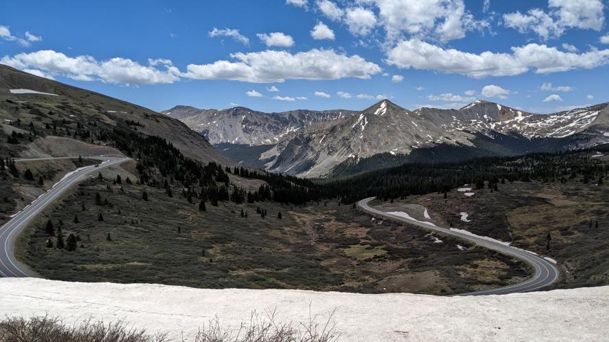
As we climb up through a series of gulches (Short, Deadman’s, Harris Gulch, and Denny Gulches) for four miles from miles seven to eleven, we are surrounded by thick forest (many cottonwoods – go figure!) and follow and often hear the soothing flow of Cottonwood Creek. The views of forest giving way to barren steep mountainsides is dramatic along the majority of the climb. At about 17½ miles we climb above the tree line and see a mighty switchback that leads to the pass summit and Continental Divide about a mile up the mountain.
![Cycling Cottonwood Pass, Colorado Cycling Cottonwood Pass, Colorado - photo collage, PJAMM Cycling logo in corner, various close up views of wildflowers in spring at Cottonwood Pass]()
Cottonwood Pass in spring.
![Cycling Cottonwood Pass, Colorado Cycling Cottonwood Pass, Colorado - PJAMM Cycling logo in corner, bike parked against boulders next to sign for Holy Water]()
Mile 12.8 -- access to the Holy Water climbing wall.
![Cycling Cottonwood Pass, Colorado Cycling Cottonwood Pass, Colorado - photo collage, PJAMM Cycling logo in corner, various aerial views of climb's final switchback, two-lane, well paved highway road]()
Final switchback of the climb.
The views at the top of the pass are absolutely breathtaking and make the climb a must for those cyclists in search of challenging climbs that include spectacular views.
![Cycling Cottonwood Pass, Colorado Cycling Cottonwood Pass, Colorado - photo collage, PJAMM Cycling logo in corner, bike parked next to Share the Road sign on roadside overlooking mountainside, hairpin turn below just before the Pass]()
Hairpin just before the pass.
View south from the pass.
![Cycling Cottonwood Pass, Colorado Cycling Cottonwood Pass, Colorado - photo collage, PJAMM Cycling logo in corner, aerial views of roadway snaking up mountainside, looking down on the pass, Cottonwood Pass and Continental Divide sign at climb's finish]()
Left photo: Pass lower right corner;
Middle photo: Aerial view down on the pass;
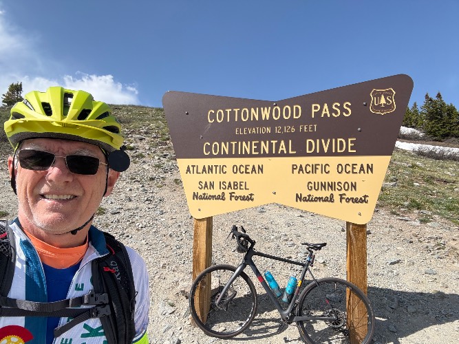
Right photo: Pass/Continental Divide sign at the climb’s finish.
![Cycling Cottonwood Pass, Colorado Cycling Cottonwood Pass, Colorado - pre-paving of back side of pass prior to 2019, bike parked against red gate closing off dirt portion of road]()
Until September 2019, the east (back) side of the pass was not open.
![Cycling Cottonwood Pass, Colorado Cycling Cottonwood Pass, Colorado - photo collage, PJAMM Cycling logo in corner, views down the backside of Cottonwood Pass, aerial views of road snaking up moutainside]()
View north down the backside of Cottonwood Pass
Paved as of September 2019
Ken Read (CAN Olympic Team 1976, 1980; 5 World Cup wins), Canmore, Alberta, Canada, writes of this climb on August 4, 2019: “Rode the pass today -- newly paved right to the pass & they are preparing to pave the west approach. Lines most of the way up, with a white shoulder line as well which helps for the few cars and trucks - the few there are.”
Continental Divide Top 100 US Bike Climbs
![Independence Pass CO - Continental Divide Sign cycling Independence Pass CO - Continental Divide Sign]()
Wolf Creek Pass (top photo): Southwest Colorado (Pagosa Springs);
Independence Pass: Central Colorado (Aspen);
Cottonwood Pass: Central Colorado (Buena Vista).
![Trail Ridge - Continental Divide]()
Trail Ridge: Stops nine miles short of the Divide.
![]()
Steepest ¼ mile starts at mile 12.1 (9.1%) and mile at 11.8 (7.4%).
![Cycling Cottonwood Pass, Colorado Cycling Cottonwood Pass, Colorado - photo collage, PJAMM Cycling logo in corner, Historic Train Museum]()
Be sure to visit the historic train museum and McPhelemy Park at the climb start.
![Cycling Cottonwood Pass, Colorado Cycling Cottonwood Pass, Colorado - informational signs about Historic Vistas, Mountain Getaways]()
![Cycling Cottonwood Pass, Colorado Cycling Cottonwood Pass, Colorado - monument with placard reading "To our Defenders in memory of Ernest Clifford Sexton, William Preston Eyre, William Joseph Walsh, and William Cradle"]()
From PJAMM contributor Brett Dixon, Colorado, for the back side of the pass: “The west side of Cottonwood Pass is dirt all the way down. It is often in great shape for climbing this time of year, but the descent demands attention on skinny tires.” Brett also provides a summary of his experience with Cottonwood Pass:
“Cottonwood Pass, also known as County Road 306 from the east and County Road 209 from the west, is a gem of the Sawatch Range. The west side of the pass is hard-packed dirt, which deters many road cyclists. However, this also cuts down on traffic from the east side, which is graced with generally excellent pavement. The climb up the east side covers 19.2 miles from Buena Vista with approximately 4,200 feet of elevation gain. The high point stands at 12,126 feet, which can be problematic for visiting cyclists who do not have time to acclimate to high altitude.
The starting point for this route is at the US 24/CR 306 traffic light in Buena Vista. You get out of the town pretty quickly and into some open terrain that is often accompanied by a headwind. The first half of the climb is relatively easy, with an average grade in the low single digits, and provides a great opportunity to warm up. The climbing really starts 12 miles in at the Denny Creek Trailhead with a wall of double-digit grades for less than one mile. The grades back off a bit after this section and remain fairly constant for the remainder of the climb. The final four miles are marked with a few curves and switchbacks. Your efforts are rewarded with a spectacular view at the top.
The low traffic, smooth surface, and long stretches of straight road make this a special route for those who enjoy turning around and descending after the climb. It is easy to sustain speeds between 40 and 50 mph without much effort and even push 60 mph at the steepest points. Professional racers flirt with 70 mph around the Denny Creek Trailhead during the USA Pro Challenge. Exercise caution on the way down as you are likely to gain more speed than usual on the return to Buena Vista.
This is a two-lane road the entire climb, but, other than a fairly congested first couple miles, traffic is light and travels at a reasonable speed. There are no bike lanes or shoulders (but many turnouts -- irrelevant for the most part to us cyclists) yet this feels to be a comfortable and safe climb.
Cottonwood Pass is 94 miles from Colorado Springs and 120 miles from Denver. This is such an exceptional climb that it is surely worth traveling to for a day trip, or an overnight in Buena Vista.
An excellent summary of the climb, along with photos is found at Bike to Cottonwood Pass posted by the Colorado Guy.
![]()
That’s a wrap!

 We've partnered with Sherpa-Map.com to bring you the best route planning tool. With a PRO Membership you can use this climb as a reference when creating your route.


