21.1
PDI
9.5 mi
DISTANCE
3,238 ft
GAINED
6.5 %
AVG. GRADE
FULL CLIMB STATS
INTRO
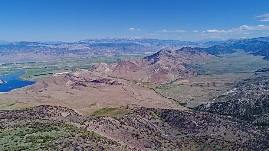
"The east side of scenic Monitor Pass is another tough California climb that rises out of the high desert very close to the Nevada border. A more difficult ascent than the western side, you are in a canyon early on and the grade is moderate and fairly steady. Soon you move out of the drainage and up the ridge and encounter several big switchbacks with increasing grade. There are big views down into the valley in places. The steepest stretch on the ascent is approaching the Alpine County line and then the grade eases off. You move toward a small section of trees at the summit as you approach the signed top at an elevation of over 8,000 feet." (This quote is presented with the approval of John Summerson, from his book, The Complete Guide to Climbing (by Bike) in California, pg. 108.)
PJAMM App Death Ride trip page is below.
PLAN YOUR ROUTE
The average grade of this 9.5 mile climb is 6.5%. 70% of the climb is at 5-10% average grade and 5% at 10-15%. None of the climb exceeds 15% grade. The steepest quarter-mile is 9.2% and steepest continuous mile is 8.3%.
Use the “Routes in Area” button in the menu to see what other climbs are in the area.
Roadway: Excellent condition two lane highway.
Traffic: Mild. This is a safe climb.
Parking: If you are not riding from Markleeville for this climb, park at the climb start just off Highway 395 - Map; Street View.
Provisions: The closest provisions for this climb are in Markleeville 23 miles northwest of the start on Highway 89, or Topas on Highway 395, four miles north of climb start.
Weather and Gear: Extremely hot during the summer and cold during the winter. Be sure to consult the PJAMM "Full Forecast" feature for the time you expect to arrive at the finish to assess what clothing to bring on your ride.
Altitude: You finish 3,000' higher than you start so the weather may be cooler at the top. There will also be 24% less altitude at the summit than at sea level.
Before heading out on any cycling adventure check out our Things to Bring on a Cycling Trip and use our interactive check list to ensure you don't forget anything.
We have always stayed in Markleeville for the climbs in the area (PJAMM Climb page: Markleeville - Death Ride). There are also a lot of house rental options in the area. The annual Death Ride is a wildly popular bike climbing event which you should consider trying if you enjoy climbing by bike - beware though, it is an extremely difficult event - Official Website.
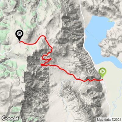
ROUTE MAP
MEMBER RATING
CURRENT WEATHER
PJAMM TRIPS ADVENTURE STARTER BUNDLES
Check out PJAMM Adventure's prepackaged (self-guided) cycling trips. They will help you plan, document and conquer your next adventure.
NEARBY CLIMBS (0) RADIAL PROXIMITY
FROM No Climbs Found
MEMBER REVIEWS & COMMENTS
Let us know what you thought of this climb. Signup for our FREE membership to write a review or post a comment.
Already have an account?
LOG IN HERE
Jghanaie
Road this last Sunday as it was recently opened. Traffic but respectful and lots of places to pull over and stretch if you would like. Still snow on the top.


