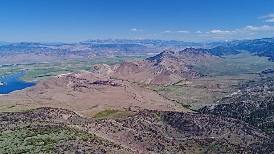
Monitor Pass East Bike Climb - PJAMM Cycling

21.1
PDI
9.5 mi
DISTANCE
3,238 ft
GAINED
6.5 %
AVG. GRADE

FULL CLIMB STATS

INTRO

"The east side of scenic Monitor Pass is another tough California climb that rises out of the high desert very close to the Nevada border.  A more difficult ascent than the western side, you are in a canyon early on and the grade is moderate and fairly steady.  Soon you move out of the drainage and up the ridge and encounter several big switchbacks with increasing grade.  There are big views down into the valley in places.  The steepest stretch on the ascent is approaching the Alpine County line and then the grade eases off.  You move toward a small section of trees at the summit as you approach the signed top at an elevation of over 8,000 feet." (This quote is presented with the approval of John Summerson, from his book, The Complete Guide to Climbing (by Bike) in California, pg. 108.)

PJAMM App Death Ride trip page is below.  
The average grade of this 9.5 mile climb is 6.5%.  70% of the climb is at 5-10% average grade and 5% at 10-15%.  None of the climb exceeds 15% grade.  The steepest quarter-mile is 9.2% and steepest continuous mile is 8.3%.

Use the “Routes in Area” button in the menu to see what other climbs are in the area. 
Roadway:  Excellent condition two lane highway.

Traffic:  Mild.  This is a safe climb. 

Parking:  If you are not riding from Markleeville for this climb, park at the climb start just off Highway 395 - MapStreet View.
Provisions:  The closest provisions for this climb are in Markleeville 23 miles northwest of the start on Highway 89, or Topas on Highway 395, four miles north of climb start. 

Weather and Gear: Extremely hot during the summer and cold during the winter.  Be sure to consult the PJAMM "Full Forecast" feature for the time you expect to arrive at the finish to assess what clothing to bring on your ride.

Altitude:  You finish 3,000' higher than you start so the weather may be cooler at the top.  There will also be 24% less altitude at the summit than at sea level. 
Before heading out on any cycling adventure check out our Things to Bring on a Cycling Trip and use our interactive check list to ensure you don't forget anything.
We have always stayed in Markleeville for the climbs in the area (PJAMM Climb page:  Markleeville - Death Ride). There are also a lot of house rental options in the area.  The annual Death Ride is a wildly popular bike climbing event which you should consider trying if you enjoy climbing by bike - beware though, it is an extremely difficult event - Official Website

MEMBER RATING

Difficulty: Challenging
5
Road
4
Traffic
3
Scenery

CURRENT WEATHER

PJAMM TRIPS ADVENTURE STARTER BUNDLES

Check out PJAMM Adventure's prepackaged (self-guided) cycling trips. They will help you plan, document and conquer your next adventure.
ALL TRIPS
Browse all of our prepackaged trips and find your next adventure!
Death Ride (Tour of the California Alps)
United States (CA)
7 ROUTES
19 POIs
ROUTE STATS (TOTAL)
104.2
mi
DISTANCE
14,111
ft
ELEV. GAIN
Lake Tahoe
United States (CA,NV)
18 ROUTES
32 POIs
ROUTE STATS (TOTAL)
245.7
mi
DISTANCE
35,240
ft
ELEV. GAIN

NEARBY CLIMBS (0) RADIAL PROXIMITY

FROM
No Climbs Found

MEMBER REVIEWS & COMMENTS

Let us know what you thought of this climb. Signup for our FREE membership to write a review or post a comment.
Already have an account?

Apr 22, 2024
difficulty: Challenging
scenery: 3
traffic: 4
road: 5
Apr 22, 2024
scenery: 3
traffic: 4
road: 5
Road this last Sunday as it was recently opened. Traffic but respectful and lots of places to pull over and stretch if you would like. Still snow on the top.
ROUTE MAP
PROFILE TOOL
Route Data
S.G. (%)
hide
Segment Data
hide
CLIMB SUMMARY

Cycling Monitor Pass East - aerial drone photo of long straight stretch of road looking west from the pass

Cycling Monitor Pass, home of the Death Ride - an epic Sierra Nevada bike climb.

Photo - Aerial view west from location directly above Monitor Pass markers.

California Top 10 Most Epic Climb 

Climb summary by PJAMM’s John Johnson.

Visit our Death Ride page for detailed information on each route and climb in this ride.

Cycling Monitor Pass East and West - PJAMM cyclists at finish of Death Ride holding up 5 fingers for 5 passes - skeleton  

Monitor Pass East and West are 2 of the Death Ride’s 5 climbs.

This climb begins about 22 miles southeast of the tiny Sierra town of Markleeville (home of the annual 5 pass/15,000' Death Ride).  Ride 9.5 miles gaining 3,348’ to elevation 8,335 at 6.5% average grade.

Climbing Monitor Pass East  by bike - beginning of climb - highway sign for Markleeville

Start

    Climbing Monitor Pass East  by bicycle - Death Ride cyclists descending through canyon

Start during the Death Ride

Climbing Monitor Pass East  by bicycle - Death Ride cyclists descending through canyon

Aerial photo of canyon at start of climb.

Climbing Monitor Pass East  by bicycle - Death Ride cyclists descending through canyon

Aerial Photo just leaving the canyon above.

Roadway can be seen snaking towards the pass middle of photo.

Bicycle ride up Monitor Pass East  - cyclist on roadway with view east of valley and mountains

Just leaving the lower canyon near the start.

Bike climb of Monitor Pass East  - aerial drone photo of Hwy 89

Aerial view of the giant switchbacks from mile 4.4 to 5.8 -

 average 7.5% through this segment.

Bike ride up Monitor Pass East  - view of road and hillside

Around mile 7 (2 ½ more to go).

While the climb does have some sustained pitches in the 8-9% range, for the most part it is a smooth 5-7% climb from bottom to top. The first half of the ride covers about 1,650' at 6.9% and the second half about 1,550' at 6.4%.

The roadway surface is exceptional and while this is a state highway and traffic does whiz by at considerable speed, there is a decent bike lane for most of the climb and a light to medium flow of traffic. The descent is smooth and fairly straight once a couple of large hairpins are negotiated at the top. The landscape is desert-like, similar to the high desert of Arizona. However, the western side of Monitor Pass and Markleeville area is softer in climate and appearance (alpine forest, grassy meadows, bordered by dramatic sierra cliffs/mountains).

Monitor Pass

Biking up Monitor Pass East  - cyclist riding west at pass - view west

There are two summit signs at the top of the climb.

Cycling Monitor Pass East  - bicyclist riding west as the pass - roadway and mountains 

Starting the descent of Monitor West after climbing Monitor East.

MARKLEEVILLE BIKE CLIMBS + DEATH RIDE

Photo - from upper left clockwise:

Ebbetts Pass East; Monitor Pass West; Ebbetts Pass West. and Monitor Pass East.

That’s a wrap!!