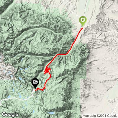
Beartooth Pass North Bike Climb - PJAMM Cycling

7.8
FIETS
30 mi
DISTANCE
5,783 ft
GAINED
3.4 %
AVG. GRADE

FULL CLIMB STATS

Page Contributor(s): Bruce Hamilton/Stacy Topping, USA

INTRO

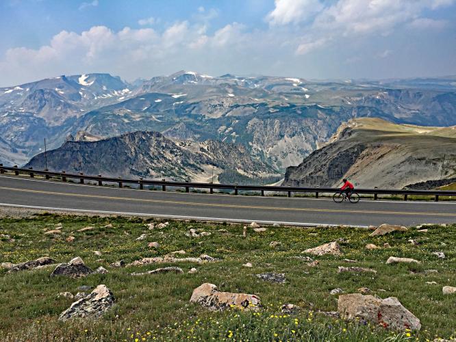
"Likely the most difficult ascent in Montana, the north side of Beartooth Pass is a long and specular hill climb into the rugged Beartooth Mountains of southern Montana near the border with Wyoming. The grade begins as quite shallow and gradually steepens (but is never steep) as you generally head south. Once you have gained some altitude you encounter some amazing views down into the valley as you ascend multiple switchbacks with exposure in places. Around mile 22 the climb pops out above treeline and heads across spectacular alpine terrain as you cross into the state of Wyoming. At mile 27 there is a descent before the final push up to isolated Beartooth Pass at 10,947 feet..."(This quote is presented with the approval of John Summerson, from his book, The Complete Guide to Climbing (by Bike), 2nd Edition, pg. 191.)
The altitude is more a factor than the gradient on this climb (nearly 11,000' and 33% less oxygen).  The average grade is 3.3% (4.1% climb only).  57% of the climb is at 0-5% grade and 30% at 5-10%. The steepest quarter mile is 10.2% and the steepest mile 6.6% (see Steepest Gradient tool in Gradient Tool section). 

See more details and tools regarding this climb's grade via the “Profile Tool” button above.
Roadway:  Excellent.  Beartooth Highway is closed during winters.  Check roadway conditions at mdt.mt.gov - Beartooth Hwy.

Traffic:  Moderate and slow moving.  There will be many Harley Davidson motorcycles cruising this road leading up to the South Dakota Sturgis Motorcycle Rally, which is in the first week of August each year. 

Parking:  We parked on a side street near the start when we climbed Beartooth Pass.  See also Google Maps - Parking in Red Lodge.  You can avoid the first 7.3 miles of riding at 2% on Highway 212 by parking at the parking lot with the Custer National Forest sign:  MapStreet View.
Clothing:  This climb finishes above 10,000', which is 5,000' above the start.  Consult the PJAMM "Full Forecast" feature for the time you expect to arrive at the finish to assess what clothing to bring on your ride. 

Provisions:  This is a 60 mile out and back with no water or food along the way - plan accordingly. 
Before heading out on any cycling adventure check out our Things to Bring on a Cycling Trip and use our interactive check list to ensure you don't forget anything.
This is a nice climb to do on your way to Yellowstone National Park.  We rode Beartooth Pass then drove 68 miles to the Northeast Entrance Station to Yellowstone and then another 28 to Roosevelt Lodge (Google Map + Reviews)  where we stayed before doing the Yellowstone Grand Loop the next day (Map of Route).  On the Grand Loop you pass many Yellowstone attractions, including Old Faithful and the Continental Divide. 

This climb starts in Red Lodge, MT where there are many hotel options for your stay.  If you are staying in the area for a longer visit, there are many great cabin rentals in the area too.

ROUTE MAP

MEMBER RATING

Difficulty: Moderate
4.5
Road
4.5
Traffic
5
Scenery

CURRENT WEATHER

PJAMM TRIPS ADVENTURE STARTER BUNDLES

Check out PJAMM Adventure's prepackaged (self-guided) cycling trips. They will help you plan, document and conquer your next adventure.
ALL TRIPS
Browse all of our prepackaged trips and find your next adventure!
Glacier National Park
United States (MT), Canada
10 ROUTES
11 POIs
ROUTE STATS (TOTAL)
67.2
mi
DISTANCE
13,140
ft
ELEV. GAIN
Yellowstone and the Tetons
United States (MT,WY)
20 ROUTES
52 POIs
ROUTE STATS (TOTAL)
523.8
mi
DISTANCE
43,011
ft
ELEV. GAIN

NEARBY CLIMBS (0) RADIAL PROXIMITY

FROM
No Climbs Found

MEMBER REVIEWS & COMMENTS

Let us know what you thought of this climb. Signup for our FREE membership to write a review or post a comment.
Already have an account?

Sep 1, 2022
difficulty: Moderate
scenery: 5
traffic: 4
road: 5
Sep 1, 2022
scenery: 5
traffic: 4
road: 5
Spectacular ride. The views as you gain elevation are exceptional. This is a long climb however it stays around 5%. I saw 8% once. The switchbacks in the middle reminded me of Horseshoe Meadows Road, just not as steep.
Jul 23, 2021
difficulty: Moderate
scenery: 5
traffic: 5
road: 4
Jul 23, 2021
scenery: 5
traffic: 5
road: 4
I didn’t finish this ride because the wind was a bit too strong after rock creek vista but the climb I did do wasn’t steep and the road was in good condition. I finished 40 of the 60 miles starting at US forest service beartooth ranger station (I found other cyclists also park here) finishing at the rock creek vista. Although most of the ride there is very little/no shoulder the limited traffic made this okay. Highly recommend! Above I find the traffic rating a bit confusing! It was light traffic..5 makes it seems heavy
ROUTE MAP
PROFILE TOOL

Climb Profile Not Found
CLIMB SUMMARY

Cyclist rides on two-lane highway roadway looking down on mountains, panoramic photo

Cycling Beartooth Pass (Montana) is one of the greatest bike climbs in the United States

This climb is has been hailed for the past 50 years as “the most beautiful road in the United States.”

Ride 30 miles gaining 6,040’ to elevation 10,949 at 3.4% average grade.

Climb summary by PJAMM’s John Johnson.

Before heading out to Montana on your cycling adventure, be sure to rely on our list of Things to Bring on a Cycling Trip, and use our interactive checklist to ensure you don't forget anything.

Cycling Beartooth Pass North, Montana - photo collage, US Forestry service sign reds "Welcome to Wyoming," PJAMM Cyclist stands next to Beartooth Pass elevation summit sign, panoramic views of PJAMM Cyclist riding on two-lane mountain roadway

This is a US Top 10 Most Scenic Bike Climb.

This is an absolutely gorgeous climb - there is no room for debate about this.  The climb throughout is fairly mild and it is the length, elevation gain and altitude that puts the climb legitimately in the Top 100 U.S. Climbs - it would be in the Top 25 Most Scenic Climbs if we were to create such a list.  

Climbing Bear Tooth Pass North by bike - start of climb - roadway sign

Beartooth Pass from the north begins in Redlands, Montana.

Population 68,747 (2017); elevation 1,358’.

We enter Custer National Forest at mile 4.8 and begin climbing up a canyon where the roadway begins a six mile series of spectacular switchbacks (see slideshow) at mile 14.  

Bike climb up Bear Tooth Pass North - roadway and Custer Gallatin National Forest sign

Mile 7.3 - Custer National Forest

Established 1908 by Teddy Roosevelt; 1,188,130 acres.

This is the alternate start spot - paved parking here.

The more scenic Beartooth North route begins eight miles from Red Lodge at the beginning of the Beartooth Scenic Byway.  At this location, there is a public parking lot where you can park your car and begin our climb, thus eliminating 7.3 miles from Red Lodge that gain you only 790’ at 2% (dropping the FIETS index only a bit from 7.80 to 7.62).  Here is a link to the RideWithGPS map for this alternate climb route.

Beartooth Pass is, not surprisingly, in the Beartooth Mountains of south central Montana and northwest Wyoming.

photo collage, views on the climb headed toward the switchbacks, including green space along roadways, freshly paved two-lane roadway, mountains, PJAMM Cycling logo in corner

Exceptional views as we climb towards the switchbacks.

Bicycle ride up Bear Tooth Pass North - roadway far below

Very few trees - minimal visual obstructions of the surrounding views.

Seven giant hairpins for six miles from mile 14.3 to 20.2

The hairpin section is 6 miles at 4.5% from elevation 7,900’ to 9,300’ at 4.5%.

The views up towards the roadway to come, and back at the roadway already travelled are magnificent along the switchback corridor (see slideshow).  It is along this stretch that we fully appreciate being on the bike as we have none of the restrictions of motorists along this scenic route - we can stop where we please, cross the road (when safe, of course), go any speed we please and, quite simply, fully appreciate the splendor of this magnificent climb.  Words do not do justice to the climb, although we believe the photographs in the slideshow above prove our point.  

photo collage, Rock Creek Vista Point, PJAMM Cycling logo in corner

This climb is never “difficult” in the sense of steepness or challenging grade, but it is long and climbs to high elevation.  We had trained and were prepared for many days of back-to-back-to-back Top 100 climbs, yet Beartooth was more demanding than anticipated.  We feel it’s primarily the altitude that taxes the rider, particularly those from lower elevation venues that cannot train for altitude before tackling this climb.  The first ten miles of the full route gain only 1,165' at 2% average grade, while miles 10-26.5 pick up to 4.5% average grade, gaining  4,075' along the way.  At mile 26.5 there is a 1.3 mile -4.9% average grade descent (-350') followed by a final two miles at 3.8% (we could have gone without that 350’ ascent on the way back to Red Lodge!).  

Photo collage, signs along the route, PJAMM Cycling logo in corner 

Some of the informative signs along the way . . .

Montana and Wyoming state lines

Enter Wyoming and Leave Montana at mile 23.7.

The route itself is very simple:  Climb east on Highway 212 (Beartooth Highway) out of Red Lodge, MT  for 30 miles until you reach Beartooth Pass.  

Cycling to summit of Bear Tooth Pass North - Cyclists with bike at pass and and elevation sign.

Summit.

Beartooth Highway is the highest paved highway in the northern Rocky Mountains and was referred to by the late CBS news correspondent Charles Kuralt as "the most beautiful drive in America” which offers the following description of the roadway:

The Beartooth Highway is a 68-mile travel corridor, beginning (at its easternmost terminus), just south of Red Lodge, Montana at an elevation of 6400 feet and ending (at its westernmost terminus) near the Northeast Entrance to Yellowstone National Park and Cooke City and Silver Gate, Montana, at an elevation of 7500 feet. In between those two elevations, the road rises to 10, 947 feet at Beartooth Pass in Wyoming. The section of the Beartooth Highway that has been awarded the National Scenic Byways “All-American Road” status is a 54 mile section of the Highway beginning 8 miles south and east of Red Lodge and ending just east of Cooke City, Montana.

Cycling Beartooth Pass North, Montana - wildflowers along the route

Our research indicates there had been a race up Beartooth from Red Lodge in recent years past, but it is unclear if it has survived - we welcome and will include any input regarding the viability of this event.  A past post for the event Beartooth Blitz notes, “The run up Beartooth Pass was recently named one of the 5 top bike climbs in the nation, the Beartooth Pass is a once-in-a-lifetime ride.”

Roadway Surface and Traffic Report:  The roadway is in excellent condition.  Traffic was fairly heavy when we climbed the pass on August 3, 2015.  We were surprised that there were many more motorcyclists (the touring, not low slung racers) than cars on Beartooth - we later learned this was related to the beginning of the annual Sturgis SD Harley Davidson week-long festival was about to begin.

Bike climb Bear Tooth Pass North - cyclist on perfect road

The roadway is in pristine condition. 

In a nutshell - if you ever have the opportunity to do this climb - DO IT!  Do not pass up the opportunity - it is a Bucket List Climb.  We loved the scenery, the altitude challenge, the spectacular views and, although we are very partial to these, the switchback views, particularly looking back at the roadway that we had already travelled in the far distance well below us (representative photograph).

The Challenge:  We have mapped and recommend for anyone interested in: (a) a significant climbing day/challenge, and (b) expanding the spectacular experience of Beartooth Pass North - the following out-and-back ride from the beginning of Beartooth Scenic Highway North to the start of Beartooth Highway Climb South and back which involved 88 miles riding and 9,866’ of climbing (Map).

Access to full Climb Summary requires a PJAMM Cycling PRO Membership!

It takes less than a minute to sign up & with your PRO membership you can:
  • Rate climbs, post comments and share your experiences on any of our climb pages
  • Create bucket lists of climbs & mark the dates you complete them
  • Weather data for all climbs - Start & Finish
  • Upload photos to your member page to customize your PJAMM Cycling experience
  • Utilize all of our interactive tools - Profile & Routes in Area
  • Download climb route .gpx files
Sign up for a PRO Membership

Already have an account? LOG IN HERE