![]()
Cycling Beartooth Pass (Montana-Wyoming)
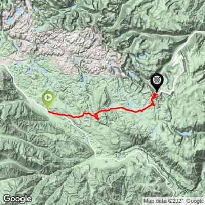
Ride 30 miles gaining 6,040’ to elevation 10,949 at 3.4% average grade.
Climb summary by PJAMM’s John Johnson.
Before heading out to Montana on your cycling adventure, be sure to rely on our list of Things to Bring on a Cycling Trip, and use our interactive checklist to ensure you don't forget anything.
Beartooth pass is one of the greatest bike climbs in the United States. This climb has been hailed for the past 50 years as “the most beautiful road in the United States.” The climb is in the Beartooth Mountains and Gallatin and Custer National Forests and connects Red Lodge Montana wth Cooke City and Yellowstone National Park in Wyoming.
![]()
This is a US Top 10 Most Scenic Bike Climb.
"Ascending Beartooth Pass from the north is an unequivocally stunning experience; its beauty is beyond dispute. The gradient of the climb is relatively gentle throughout, but the combination of its length, elevation gain, and altitude rightly secures its position among the Top 100 U.S. Climbs. Additionally, it is celebrated as one of the Top 10 Most Scenic U.S. Bike Climbs due to its breathtaking landscapes."
START
![]()
Beartooth Pass from the north can begin in Redlands, Montana.
Population 68,747 (2017); elevation 1,358’.
The more scenic Beartooth North route begins in the charming Montana town of Red Lodge (2020 population: 2,257), at the beginning of the Beartooth Scenic Byway. We enter Custer National Forest at mile 7.3 and begin climbing up a canyon where the roadway begins a six mile series of spectacular switchbacks at mile 14.
FIRST 14 MILES
![]()
Mile 7.3 - enter Custer National Forest
Established 1908 by Teddy Roosevelt; 1,188,130 acres.
This is the alternate start spot - paved parking here.
The first 14 miles are a great warm up the next 16 miles of high altitude climbing. This segment averages 3% and leads up to the alpine surroundings which end as we climb above tree level at mile 17 at just over 8,000’.
An alternate start point if you prefer to eliminate the first less scenic miles from Red Lodge is to start at the Custer National Forest sign at mile 7.3 where there is a public parking lot. The first 7.3 miles from Red Lodge average 2% with 790’ of elevation gain. We started in Red Lodge the two times we climbed Beartooth Pass and enjoyed the entire experience - at just over 30 miles, Beartooth Pass is the10th longest climb in the United States.
![]()
Scenes along the first 14 miles of the climb.
Beartooth Highway (Route 212) opened in 1936 and is generally closed due to snow all but 5-6 months of the year from around May to October.
FIRST SET OF BEARTOOTH HAIRPINS![]()
Beginning at mile 14.4 there are 6 hairpins for 5.8 miles averaging 4.5%.
"Beartooth is ranked among the top 10 best hairpin bike climbs in the United States."
![]()
Beartooth Pass is situated in the Absaroka-Beartooth Wilderness and spans the Beartooth Mountains, which are part of the greater Rocky Mountains range. The pass crosses through the Custer and Shoshone National Forests.
![]()
The lack of trees combined with the imposing cliffs provides expansive views of the winding hairpins as we ascend. The views up towards the roadway to come, and back at the roadway already traveled are magnificent along the switchback corridor (see slideshow). It is along this stretch that we fully appreciate being on the bike as we have none of the restrictions of motorists along this scenic route - we can stop where we please, cross the road (when safe, of course), go any speed we please and, quite simply, fully appreciate the splendor of this magnificent climb. Words do not do justice to the climb, although we believe the photographs in the slideshow above prove our point.
MILES 19.5 TO 26.5
IN BETWEEN THE 2 SETS OF BEARTOOTH HAIRPINS
![]()
Rock Creek Vista is at mile 19.5 and at the very end of the first set of Beartooth hairpins.
![]()
This climb is never “difficult” in the sense of steepness or challenging grade, but it is long and climbs to high elevation. We had trained and were prepared for many days of back-to-back-to-back Top 100 climbs, yet Beartooth was more demanding than anticipated. We feel it’s primarily the altitude that taxes the rider, particularly those from lower elevation venues that cannot train for altitude before tackling this climb. The first ten miles of the full route gain only 1,165' at 2% average grade, while miles 10-26.5 pick up to 4.5% average grade, gaining 4,075' along the way. At mile 26.5 there is a 1.3 mile -4.9% average grade descent (-350') followed by a final two miles at 3.8% (we could have gone without that 350’ ascent on the way back to Red Lodge!).
![]()
Enter Wyoming and Leave Montana at mile 23.7.
The route itself is very simple: Climb east on Highway 212 (Beartooth Highway) out of Red Lodge, MT for 30 miles until you reach Beartooth Pass. This is a very long climb - the ninth longest in the US - PJAMM Cycling Top 100 Longest US Road Bike Climbs.
SECOND SET OF BEARTOOTH HAIRPINS
![]()
There is a stark contrast from the lush forests and alpine meadows of the first half of the climb with the jagged rock formations and snow-capped peaks surrounding us the second half of the climb. There are several glaially formed lakes visible along the upper part of the climb.
![]()
4 fun hairpins just before the finish for 1 mile at 4.5% grade.
FINAL 3 MILES
![]()
Over the last 3 miles we encounter a 1.5 mile 5% descent from mile 26.5 to 28 and the second set of hairpins on one of the greatest hairpin climbs in the US.
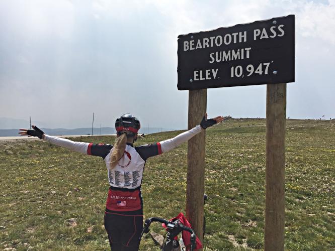
BEARTOOTH SUMMIT
![]()
You’ll feel it at nearly 11,000’ elevation.
This is the highest paved point in
![]()
Views from the summit.
Beartooth Highway was referred to by the late CBS news correspondent Charles Kuralt as "the most beautiful drive in America” which offers the following description of the roadway:
The Beartooth Highway is a 68-mile travel corridor, beginning (at its easternmost terminus), just south of Red Lodge, Montana at an elevation of 6400 feet and ending (at its westernmost terminus) near the Northeast Entrance to Yellowstone National Park and Cooke City and Silver Gate, Montana, at an elevation of 7500 feet. In between those two elevations, the road rises to 10, 947 feet at Beartooth Pass in Wyoming. The section of the Beartooth Highway that has been awarded the National Scenic Byways “All-American Road” status is a 54 mile section of the Highway beginning 8 miles south and east of Red Lodge and ending just east of Cooke City, Montana.

Our research indicates there had been a race up Beartooth from Red Lodge in recent years past, but it is unclear if it has survived - we welcome and will include any input regarding the viability of this event. A past post for the event Beartooth Blitz notes, “The run up Beartooth Pass was recently named one of the 5 top bike climbs in the nation, the Beartooth Pass is a once-in-a-lifetime ride.”
Roadway Surface and Traffic Report: The roadway is in excellent condition. Traffic was fairly heavy when we climbed the pass on August 3, 2015. We were surprised that there were many more motorcyclists (the touring, not low slung racers) than cars on Beartooth - we later learned this was related to the beginning of the annual Sturgis SD Harley Davidson week-long festival was about to begin.

The roadway is in pristine condition.
In a nutshell - if you ever have the opportunity to do this climb - DO IT! Do not pass up the opportunity - it is a Bucket List Climb. We loved the scenery, the altitude challenge, the spectacular views and the switchback views, particularly looking back at the roadway that we had already traveled in the far distance well below us.
BEARTOOTH SOUTH AND THE OUT AND BACK
![]()
View of the last hairpins leading to the summit from the southern approach.
Cycling Beartooth South from Cooke City
Ride 21.5 miles gaining 4,378’ at 3.6% average grade (4.7% climb only)
The Challenge: We did the full up-over-back up-down from Red Lodge which is quite the challenge at 88 miles riding and 9,866’ of climbing. This route tacks on the descent+ascent of Beartooth Pass South.
The descent of Beartooth Pass is one of the most enjoyable in the US.