Hawk Hill Bike Climb - PJAMM Cycling

2.9
PDI
1.8 mi
DISTANCE
538 ft
GAINED
5.8 %
AVG. GRADE

FULL CLIMB STATS

Page Contributor(s): Ian Dennis, Occidental, CA

INTRO

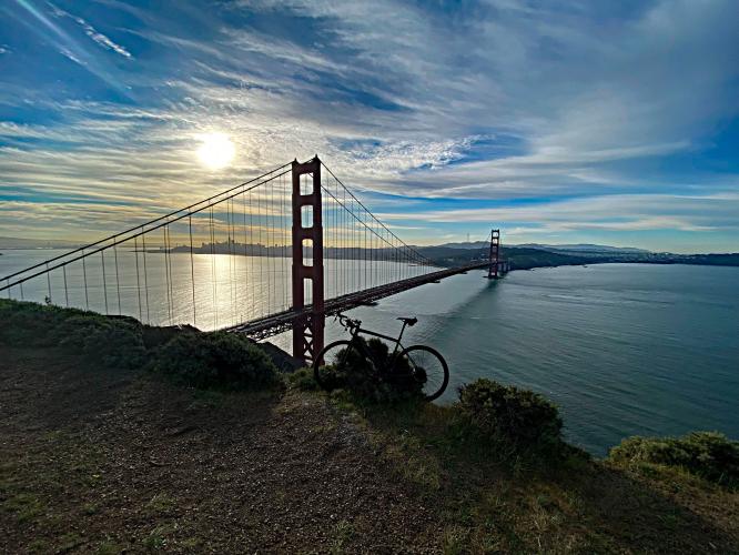
This is a short climb which offers the greatest views of San Francisco and the Golden Gate Bridge of any climb in the Bay Area.  There is also a wonderful 18 mile loop that begins at the southern GGB parking lot, crosses the Golden Gate, travels up to Hawk Hill and loops around the Marin Headlands back to the GGB and the start - Map

PLAN YOUR ROUTE

We've partnered with Sherpa-Map.com to bring you the best route planning tool. With a PRO Membership you can use this climb as a reference when creating your route.

See more details and tools regarding this climb's grade via our interactive Profile Tool.
Roadway/Traffic:
The pavement is nothing short of pristine. Traffic is not a concern and there is a bike lane for the first 2/3 of the climb until the roundabout. 

Parking:
Two of the best places to park to start a ride in San Francisco are the parking lots on either side of the Golden Gate Bridge: maps: (North)    (South)  
We always start our rides from one of these two locations - Check out our Ride Suggestions in the Full Summary for full ride ideas including this climb. 
Climb is short and you'll find all the provisions you need in the immediate area.
Before heading out on any cycling adventure check out our Things to Bring on a Cycling Trip and use our interactive check list to ensure you don't forget anything.
There's an extremely popular 18 mile loop across the GGB which includes Hawk Hill (Route). For more ideas to plan your climb, check out our full ride ideas in the Full Summary. 

Needless to say, there's no shortage of world class hotels in the San Francisco area, and if you're staying in or near the city you absolutely cannot miss out on attempting a few of the Top 10 Steepest Climbs in San Francisco.

We also recommend staying on the east side of the bay, either in Walnut Creek (access to Mt. Diablo) or the San Jose area (access to Mt. Hamilton and Mt. Umunhum), three of our all-time favorite bike climbs in California.

ROUTE MAP

MEMBER RATING

Difficulty: Easy
5
Road
5
Traffic
5
Scenery

CURRENT WEATHER

PJAMM TRIPS ADVENTURE STARTER BUNDLES

Check out PJAMM Adventure's prepackaged (self-guided) cycling trips. They will help you plan, document and conquer your next adventure.
ALL TRIPS
Browse all of our prepackaged trips and find your next adventure!
San Francisco Bay Area
United States (CA)
25 ROUTES
30 POIs
ROUTE STATS (TOTAL)
487.9
mi
DISTANCE
65,482
ft
ELEV. GAIN

NEARBY CLIMBS (0) RADIAL PROXIMITY

FROM
No Climbs Found

MEMBER REVIEWS & COMMENTS

Let us know what you thought of this climb. Signup for our FREE membership to write a review or post a comment.
Already have an account?

Oct 21, 2023
difficulty: Easy
scenery: 5
traffic: 5
road: 5
Oct 21, 2023
scenery: 5
traffic: 5
road: 5
Agreed with the other comment about taking the 18% gradient descent - breathtaking views on the other side!
Sep 5, 2021
Even better if you start from the bottom of Conzelman Dr (Fort Baker). That will give you about 780 feet of elevation in 2.4 miles.
Apr 5, 2021
difficulty: Easy
scenery: 5
traffic: 5
road: 5
Apr 5, 2021
scenery: 5
traffic: 5
road: 5
Absolutely amazing views! Highly recommend going down the 18% grade at the end rather than doing the out and back route and coming up McCoulough Road to loop back around. The views on the backside are even better than the climb!!!
ROUTE MAP
PROFILE TOOL
Route Data
S.G. (%)
hide
Segment Data
hide
CLIMB SUMMARY

Cycling Hawk Hill

Ride 1.8 miles gaining 515’ at 5.5% average grade.

Hawk Hill is at the top of Conzelman Road which is the closest road on the north side of the Golden Gate Bridge to the Pacific Ocean and Golden Gate. This ride offers the best views of the Golden Gate Bride of any bike climb in the Bay Area.

A wonderful loop begins at the southern GGB parking lot, travels across the Golden Gate, up Hawk Hill down to the Marin Headlands Visitor Center then up the backside of Hawk Hill and across the GGB to the finish - 17.9 miles gaining 2,060’ (Map).

Start the climb on Conzelman Road adjacent to the GGB northern parking lot.

Hike and ride to Battery Spencer which is on the left .3 miles up the climb.

Battery Spencer


Views along the first 1.1 miles before the fork in the road.

Go left at the fork at mile 1.1

Travel through the tunnel at the top to Battery 129 Viewpoint

Here there are wonderful views west of the pacific ocean and north to San Francisco and Sutro Tower.

Finish at Hawk Hill.

Great parking at the GGB northern parking lot - get there early.

We recommend a route that includes the Golden Gate Bridge - https://pjammcycling.com/beta/#/climb/5588.Golden-Gate-Bridge-and-Hawk-Hill-Loop