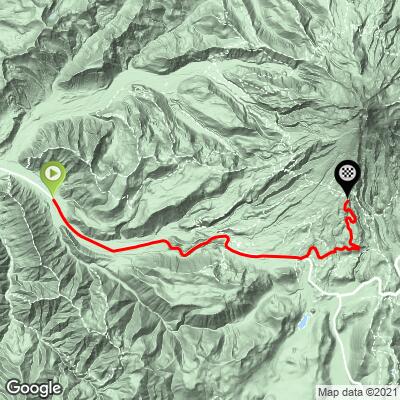
Mt. Hood Bike Climb - PJAMM Cycling

7.6
FIETS
15.1 mi
DISTANCE
4,232 ft
GAINED
5.3 %
AVG. GRADE

FULL CLIMB STATS

Page Contributor(s): Ron Hawks NV, USA; Erich Pawleka (Austria); Garrett Simpson, OH, USA

INTRO

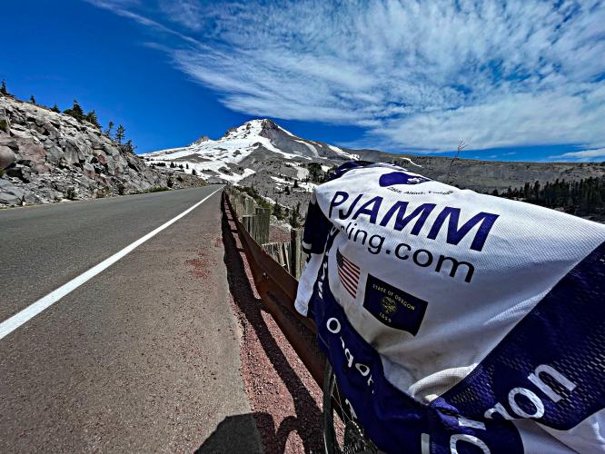
"A contender for the most difficult climb in Oregon, the ascent of Mount Hood begins by heading east on Route 26 over a moderate and gradually increasing grade. The road can carry some traffic over its four lanes, ok, a lot of traffic many days. You will pass through several small communities along the way as well as the grade gradually increases. Eventually the road squeezes down to a true two lanes, enters the woods and takes on a more mountainous feel although traffic can remain. At mile 9.7 (just past Government Camp) turn left toward the Timberline Lodge and ski area over a classic stretch of road bike climbing. This final section is steeper and scenic through thick trees for the most part and you get a break from the high speed traffic..." (Quoted from John Summerson from The Complete Guide to Climbing (by Bike), 2nd Ed., p 204.)
This 5.4% average grade bike ride is all climb and no play!  There is negligible descent on this climb which has a fair amount of variance within the 2-9% range until the final 9/10ths of a mile which jumps to 9.4% average grade.  The steepest quarter-mile of the climb is 11% and steepest mile 9.1%, both in the at the end of the climb. 7.5% of the ascent is at ≥10% grade.

 
See more details and tools regarding this climb's grade via the “Profile Tool” button.
Roadway:  Excellent.

TrafficVery heavy for the first 9.9 miles on Hwy 26 but lighter after turning onto Timberline Hwy which has a nice shoulder to the top. .  

Parking:  There are commercial/retail businesses in Rhododendron where the climb begins - ask at a business if you can leave your vehicle while you ride.  Otherwise, there is the occasional pullout or wide shoulder to park, as with this one just past climb start - MapStreet View; or Tollgate Campground and Day Use Area half a mile up the climb from the start, on the right - Map Street View.
There are provisions in Rhododendron, Government Camp (mile 9.5), and possibly at the Timberline Lodge at the finish. 
Before heading out on any cycling adventure check out our Things to Bring on a Cycling Trip and use our interactive check list to ensure you don't forget anything.
Portland is an outstanding city with an international airport.  The Portland area has no shortage of unique and whimsical vacation rental options as well.  It would be fun to combine a trip to Portland with the Mt. Hood climb. 

ROUTE MAP

MEMBER RATING

Difficulty: Strenuous
4.5
Road
2.5
Traffic
4
Scenery

CURRENT WEATHER

PJAMM TRIPS ADVENTURE STARTER BUNDLES

Check out PJAMM Adventure's prepackaged (self-guided) cycling trips. They will help you plan, document and conquer your next adventure.
ALL TRIPS
Browse all of our prepackaged trips and find your next adventure!
Crater Lake
United States (OR)
10 ROUTES
29 POIs
ROUTE STATS (TOTAL)
258.3
mi
DISTANCE
29,750
ft
ELEV. GAIN

NEARBY CLIMBS (0) RADIAL PROXIMITY

FROM
No Climbs Found

MEMBER REVIEWS & COMMENTS

Let us know what you thought of this climb. Signup for our FREE membership to write a review or post a comment.
Already have an account?

Dec 4, 2023
An alternative route to bypass 26th would be to take still creek road (it's mostly gravel but can be done easily on a road bike with 35c knobby tires. Take still creek road to trillium lake. Left at trillium take that road to 26th cross 26th to government camp rest area then use west leg road instead of the main road to timberline lodge. West leg is a service road all paved.. zero traffic.
Apr 25, 2021
difficulty: Challenging
scenery: 4
traffic: 2
road: 4
Apr 25, 2021
scenery: 4
traffic: 2
road: 4
The first part is along a main highway with a lot of traffic. After you turn off to the ski area, the gradient goes up and the traffic goes down. There is water and toilets in the lodge at the top.
Apr 12, 2021
difficulty: Strenuous
scenery: 4
traffic: 3
road: 5
Apr 12, 2021
scenery: 4
traffic: 3
road: 5
You couldn't pay me to ride on 26, but the climb up to Timberline is awesome, whether current road with cars or old road (shift to west) that was used for OBRA state climbing champs, years ago.
Jun 11, 2021
Agree 100%. Highway 26 almost always has much more traffic than this guide lists. Some of it feels downright dangerous. Maybe riding on a Tuesday morning might, maybe be acceptable. If you can find West Leg Road (usually covered by snow until July, poor pavement) it’s a great alternative to the Timberline Road climb, with almost zero cars.
ROUTE MAP
PROFILE TOOL
Route Data
S.G. (%)
hide
Segment Data
hide

Climb Profile Not Found
CLIMB SUMMARY

Bike Parked in front of sign for "Timberline Lodge, National Historic Landmark"

Cycling the mighty Mt. Hood

US #98 Hardest Bike Climb

Ride 15 miles gaining 4,300’ at 5.4% average grade.

Mt. Hood.

This is a very challenging U.S. climb, #97 US and #2 Oregon (after the little known Bear Camp West ride - #6 US Most Epic Bike Climb).

 Mt. Hood is home to the annual Tour de Hood which is described on their Facebook page as:

“The idea started as a simple one: Since the Mt Hood Cycling Classic race had the roads for the day, why limit the good time and challenge to the racers only? Tour de Hood, or the TDH as some call it, covers the same amazing course that challenged elite racers in the popular Mt Hood Cycling Classic stage race for years. The Tour de Hood will challenge you with its mountain climbs and stunning scenery and make you smile with its good food and friendly staff and volunteers. It will take your breath away both literally and figuratively!” (Tour de Hood Facebook Page).

photo collage, cyclists climb on one-lane mountain highway up to Mt. Hood, Mt. hood can be seen in the distance, snow covered mountain, evergreen trees

Before heading to Oregon for your Mt. Hood cycling adventure, be sure to rely on our list of Things to Bring on a Cycling Trip, and use our interactive checklist to ensure you don't forget anything.

The following are informative summaries from Strava members Garrett Simpson, Ohio:

Mt. Hood HC from Strava Member Garrett Simpson:


Being a cyclist who lives in Ohio, long climbs are a rarity and mountains are unfathomable. Therefore, when the opportunity presented itself to test my mettle on a real mountain, I jumped at the chance. I had a limited amount of time between dropping a friend off at the Portland Airport and making it back in time for my own flight. Therefore, I had to choose a route that would fit the time I had available and also provide a route yielding the largest elevation gain. I scoured Strava activities and segments and found a tiny village along Highway 26 called Alder Creek, which would provide the perfect distance with the largest ascent. I located a parking lot that would work as a launch point and hopped in the car.

two-lane highway roadway headed toward summit of Mt. Hood, evergreen lined roadway

Mt. Hood.

I arrived at the Ivy Bear Pizzeria and entered to inquire about parking my car in their lot while I attempted the climb. The girl with whom I spoke was incredibly nice and had no problems with the request. In hindsight, I wish I had put in an order for a pizza to be ready when I came back down the mountain, as I was in a rush at the end and a pizza sounded sublime. Unfortunately, I had to settle for a soda, which still tasted like the god’s elixir after the ride.

Climb start, bike parked next to road sign reading "Rhododendron", evergreen trees, dairyqueen

Climb start.

 
With my car in a safe location, I set off up the mountain. The first 10 miles or so were glorious as I had a tailwind and only ascended 660ft (1.25% grade). This yielded an 18mph average with very little effort. Something that is worth noting is that in Zig Zag there are 2x2 ft. grates on the shoulder around which you have to be careful. Avoiding them pushes you closer to traffic, but I encountered debris around them and the grates themselves did not look safe for road bike wheels. Steering clear of them was for the best. There were probably somewhere around 20 of these grates total, spaced every couple hundred feet throughout Zig Zag.

Laurel Hill Trail head, marker for the Historic Oregon Trail

Laurel Hill Trailhead at mile 6.6.

Once I hit mile 10 I started to realize what climbing a mountain really felt like. The next five miles ascended 1,042 ft. (3.95% grade). This was also an important section because I encountered construction around mile markers 49-54. However, I must point out that even though it was heavy construction, the workers and the cars on the road were very polite. I never felt unsafe even when the shoulder was gone and I was riding on the white line.

PJAMM Cyclist rides on shoulder of highway road, Snow capped Mt. Hood in the distance

The next five miles started to make me wonder how hard this might end up being. I ascended 1,357 ft. during this section (5.14% grade).  At this point, I had climbed 3,059 ft. - over 20 miles (2.90% grade) and I was definitely starting to feel it. Once I passed through Government Camp and got to the Timberline Highway turn, I decided to take a break for a couple of minutes to fuel up. As I was looking up Timberline Highway, I kept thinking to myself, “That looks quite a bit steeper than the first 20 miles.” Well, as soon as I started up I realized how big of a difference it truly was. My legs were already feeling a little heavy (not helped by the fact I had hiked over 20 miles - ascending over 7,000 ft. – during the four days before this climb, including a Mt. St. Helens summit attempt) - so I knew the last 5.5 miles were going to be a battle.

Views along the climb, including signs for Mt. Hood Kiwanis Camp, lodging, rock walls, evergreen trees

Scenes along the climb.

I would be lying if I said I was not tempted to turn around and coast down the mountain during the last 5.5 miles, which saw me gain another 1,954 ft. (6.73% grade). I made two very brief stops during this section as my legs no longer wanted to turn the pedals. However, a friend of mine had told me before the attempt that when I was hurting and needed motivation to look up at the mountain and the beautiful scenery. I could not believe how important that statement was - the beauty on this ride is incredible! The entire way you are living and breathing the Pacific Northwest. Massive forests, huge drop-offs and rock walls, bubbling brooks, swiftly moving rivers, and of course the mountain. When I first rounded the corner on Highway 26 that revealed Mt. Hood to me, I could not believe how momentous that occasion felt. I was amazed by its size and beauty! We as humans often feel as though we have complete dominance over Planet Earth, but staring up at that mountain made me feel so insignificant in the face of such awe-inspiring nature. Even though the last two miles were extremely difficult, the experience carried me to the top.

I had planned to continue up to the lodge as that added a couple more feet to the climb and I really wanted to maximize the elevation gain. As I got closer to the parking lot, I had an internal struggle about calling that good enough. However, I reminded myself that these opportunities are few and far between so I climbed that last steep incline and made it up to the lodge. The total at this point was 25.7 miles ridden and 5,013 ft. climbed (just short of a mile!! – 3.69% grade).

climb's finish, Timberline Lodge, sign for Mt. Hood Meadows, views looking down over evergreen forests

 
The dominant feeling at the top was one of relief. I experienced many emotional moments during the ride but once I made it to the top, I was just happy to be done. The number of people on Mt. Hood that day was impressive. Some of them were looking at me like I was crazy to have attempted the climb. One guy told me he passed me on the way up and wondered if I was going to make it; he expressed his happiness for me that I accomplished the task. I was almost out of water so I stayed long enough to fill up my bottle at the lodge bar, which was a very unique place.  I took a few pictures and then headed back down the mountain.

Signs for Pioneer Bridle Trailhead, Historic Oregon Trail

Pioneer Bridle Trailhead within the first mile of the start.


After the physical challenge of that last 5.5 mile stretch, going down that same segment was like being a kid again. I was cautious but definitely opened it up when I could and felt like I was flying. I actually passed cars going down as they were either taking in the beauty or just being extremely cautious. This section of the ride took 45:54 to go up and only 11:39 to go down. It was a BLAST!

Once I turned back onto Highway 26, the quick descent continued. Unfortunately, I hit the construction again and got held up quite a bit including a short stop during a section where they had cut it down to one lane. The next 10 miles went by in a flash.

During the entire time leading up to the attempt, I felt as though once I turned around to go back down the mountain I would barely have to do any work. Unfortunately, that was not true for the last 10 miles. As I noted earlier, I had a very nice tailwind going up the hill and the direction of the wind had not changed for the descent, so the last 10 miles were straight into a headwind. Being at 40+ miles and after all the hiking leading up to the attempt, this last portion of the ride was not very fun. I was ready to be done and the headwind did not make me a happy camper. Happily, it was not much longer until I saw the Ivy Bear holding his pizza and the ride was complete.

This was a ride of a lifetime. I cannot imagine living in an area where this is your daily reality. You can throw your bike in your car and be on 25+ routes as challenging as Mt. Hood within hours. What an amazing playground! This experience has definitely added many items to my bucket list that include iconic climbs. We only live once and seeking out these experiences, in my opinion, is what life is all about.

PJAMM Note:  The Strava segment below begins 1.8 miles down the climb than our start point.

PJAMM Cyclist Garrett Simpson stands at summit holding his bike in the air