Mix Canyon Bike Climb - PJAMM Cycling

18.2
PDI
4 mi
DISTANCE
2,178 ft
GAINED
10.4 %
AVG. GRADE

FULL CLIMB STATS

Page Contributor(s): Tony Buffington, Woodland Hills, CA, USA

INTRO

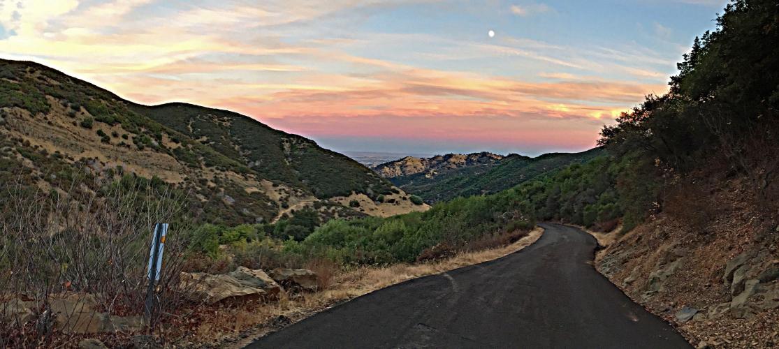
​​Mix Canyon is a short but very challenging climb near Vacaville, CA. The grade increases with each mile – mile one is 5.8%, mile two 8.8%, mile three 12.8% and, finally, the coup de grace - a whopping 13.4% for mile four. There are not many dramatic views (a couple of opportunities eastward down towards the Vacaville/Fairfield area towards the top). What makes this climb notable is the significant and difficult grade over the lasts two miles.

PLAN YOUR ROUTE

We've partnered with Sherpa-Map.com to bring you the best route planning tool. With a PRO Membership you can use this climb as a reference when creating your route.
The Mix Canyon Road climb is all about STEEP.  Average grade is 10.5% with 0 descent.  33% of the climb is at 10-15% and 16% is at 15-20%.  The steepest quarter mile is 17.2% and steepest mile 15.8%.  Mix Canyon is the second steepest mile in California (after Socrates Mine Road in Lake County), and the steepest 2 1/2 miles in CA (#8 US). 

See more details and tools regarding this climb's grade via the “Profile Tool” button.


Roadway:  The road is in average condition as of 2020.  Caution must be exercised on the descent as there are rough spots on the road, potential debris and a couple hairpins that you approach at a double digit grade.

Traffic:  Minimal.

Parking:  There are many spots to park along the road on the way to the climb.  We have parked at the corner of Mix Road and Pleasant Valley Road and warmed up for the ~mile to the climb start.  Map; Street View. 
Provisions:  There are no spots for food or water along the climb.  It can get hot in this area during the summer so bring plenty of water. 

Equipment:  Bring a bike with gearing to suit your climbing ability - this is a very steep and difficult bike climb. 
Before heading out on any cycling adventure check out our Things to Bring on a Cycling Trip and use our interactive check list to ensure you don't forget anything.
Use the “Routes in Area” button on the menu bar above to see other bike climbs in this area.

You could stay in the lovely Napa Valley (32 miles away) to do this climb, or a bit closer to the climb's beginning in Vacaville, California.  The area has a lot of vacation rental options as well.

ROUTE MAP

MEMBER RATING

Difficulty: Strenuous
3.5
Road
5
Traffic
3
Scenery

CURRENT WEATHER

PJAMM TRIPS ADVENTURE STARTER BUNDLES

Check out PJAMM Adventure's prepackaged (self-guided) cycling trips. They will help you plan, document and conquer your next adventure.
ALL TRIPS
Browse all of our prepackaged trips and find your next adventure!
Sonoma County
United States (CA)
19 ROUTES
39 POIs
ROUTE STATS (TOTAL)
269.3
mi
DISTANCE
41,801
ft
ELEV. GAIN

NEARBY CLIMBS (0) RADIAL PROXIMITY

FROM
No Climbs Found

MEMBER REVIEWS & COMMENTS

Let us know what you thought of this climb. Signup for our FREE membership to write a review or post a comment.
Already have an account?

Jun 1, 2021
difficulty: Extreme
scenery: 3
traffic: 5
road: 4
Jun 1, 2021
scenery: 3
traffic: 5
road: 4
Mix Canyon is what I would call a "novelty climb". It's just ridiculously steep at the top. How steep? It's, "don't lean back or you may loop out" steep, it's "don't stop because you will have a very hard time getting clipped in again" steep. I love it, there are almost no cars and no fast cars (the switch backs are too tight to go fast) and it gets really hot due to lack of wind during the first half when the walls are really on top of you. At the top, you can go through the gate and take the gravel road (blue ridge road) over to Gates Canyon or turn around. If you can, I recommend going to Gates. The gravel is pretty loose but doable on a road bike (maybe a slight hike a bike the first 1/4 mile with skinny tires). The view is great and Gates is a better descent. Going back down Mix is no fun for the first half. You just have to ride the brakes the entire time and hope your pads are good! Overall, a ridiculous climb but well worth it once a year or so.
Apr 9, 2021
difficulty: Challenging
scenery: 3
traffic: 5
road: 3
Apr 9, 2021
scenery: 3
traffic: 5
road: 3
A very unique climb, narrow, hidden and goes nowhere but one you definitely want to do if you like steeps. The last half is difficult climbing through a few tight turns. The descent is hair raising and can be challenging.
ROUTE MAP
PROFILE TOOL
Route Data
S.G. (%)
hide
Segment Data
hide
CLIMB SUMMARY

Cycling Mix Canyon Road

Ride a mere four miles, but at a stout 10.5% average grade.

​​Climb summary by PJAMM’s John Johnson.

Mix Canyon is a short but very challenging climb near Vacaville, California and is the eighth  steepest 2.5 mile road bike climb segment in the U.S., and the steepest in California. The grade increases with each mile – the first mile is 5.8%, mile two is 8.8%, mile three is 12.8% and, finally, the coup de grace: a whopping 13.4% for mile four.  There are not many dramatic views, with the exception of a couple of opportunities eastward down towards the Vacaville/Fairfield area near the top of the climb.  What makes this climb notable is the significant and difficult grade over the last two miles.  

Before heading out to tackle Mix Canyon, be sure to rely on our list of Things to Bring on a Cycling Trip, and use our interactive checklist to ensure you don't forget anything.

A windy, narrow road through a canyon with minimal distant views.

IMG_6074.JPG

The finish is at the “Y” up to the radio towers (left) and Blue Ridge Road (right).  

     There are no Top 100 rides in the near vicinity and this is not a “destination climb,” but it is a unique ride that is worthwhile if you happen to be travelling through or live in the area.

Views near the top on a clear day.

Photos clockwise from top left:  North; northeast; east; west.

Photos by Tony Buffington, Woodland, CA


Traffic and Roadway Surface Report:  The roadway is very narrow, essentially a wide one-laner the entire route.  The roadway surface is in moderate to somewhat poor condition in spots.  However, despite being fairly narrow, the road is safe as it has very little traffic.  The descent is technical and caution is mandatory due to the incredibly steep grade and narrow width of the roadway. The road dead-ends at a no trespass sign at the top, about 4.75 miles from the beginning of Mix Canyon Road.

Spooky at the end on a late finishing night 9-25-15.

“Mix Canyon is one of the most difficult climbs in California and the United States over a similar length.  Somewhat isolated, the first mile is fairly shallow but things get more difficult as you ride over a variable grade.  There are a few houses along the way but you should encounter little if any traffic on this very narrow route.  Soon the grade reaches double digit and stays there as the last 2 miles you will likely remember as they are steeper than California icons Bolhmon/On Orbit and Old Priest Grade and feature one of the most difficult miles in cycling.  The entire route resembles some European climbs as it is over a narrow, single lane.  Near the top are several severe switchbacks that will also get your attention, one of which contains the maximum grade of the ascent.  Towards the very top riders also receive views down into the valley.  The grade finally eases over the last 0.2 miles and at the very top the road turns into dirt in a pleasant setting.  Due to its steep grade and twisty route Mix Canyon is a technical and difficult descent as well.”  (This quote is presented with the approval of John Summerson, from his book, The Complete Guide to Climbing (by Bike), 2nd Edition, pg. 132.)