
23.4
PDI
10.2 mi
DISTANCE
3,635 ft
GAINED
6.4 %
AVG. GRADE
FULL CLIMB STATS
INTRO
This is the Heiligenblut side's other great finish on the Grossglockner High Alpine Road: rather than heading for the Hochtor tunnel, it turns off at the Guttal roundabout and follows the Glacier Road to its end at the Kaiser-Franz-Josefs-Höhe, 2369 m (7,772 ft), the lookout directly facing the Grossglockner - at 3798 m (12,461 ft), Austria's highest mountain. In all it's 16.3 km (10.1 mi) with 1108 m (3,635 ft) of climbing at a 6.4% average, and that average undersells it: the lower half out of Heiligenblut runs at close to 10%, and a short false-flat and dip in the middle pulls the overall number down.
The finish is one of the great arrival points in Alpine cycling. The Pasterze, Austria's longest glacier, curls away below the viewing terraces, the Grossglockner's pyramid fills the skyline, and marmots graze the slopes right beside the road. The last few kilometers climb steeply through a series of avalanche galleries to the top, so the view stays hidden until the very end.
The Glacier Road has real race history: the 2011 Giro d'Italia finished at the Glocknerhaus, 2137 m, partway up this route, where José Rujano won the stage on a rain-soaked day. The whole High Alpine Road is seasonal - it opened for 2026 on April 25 and typically closes in early November - so check current conditions and the weather at the top before you set off; our Weather tool is a good place to start.
PLAN YOUR ROUTE
 We've partnered with Sherpa-Map.com to bring you the best route planning tool. With a PRO Membership you can use this climb as a reference when creating your route.
 Franz-Josefs-Höhe climbs 16.3 km (10.1 mi) at a 6.4% average, gaining 1108 m (3,635 ft) from 1309 m (4,295 ft) in Heiligenblut to the Kaiser-Franz-Josefs-Höhe, with about 65 m (213 ft) of descending along the way.
The climb splits cleanly into two halves. The first 6 km, on the High Alpine Road above Heiligenblut, are the hardest sustained work - each kilometer averages between 8% and 11%, and the 6th, up to the Guttal roundabout, is the steepest at about 10.9%. Turning onto the Glacier Road, the next 3 km are a gift: a gentle dip and false flat that gives your legs a real break.
From there the road climbs again at 6-9% to the Glocknerhaus, eases to about 3% for two kilometers past it, then finishes hard - the last 2 km average close to 9-10% through the avalanche galleries before flattening onto the viewing terraces.
The steepest half kilometer averages 11.2%, the steepest kilometer 11.1%, the steepest mile 11.0%, the steepest 2 km 10.5%, and the steepest 5 km 9.5%.
Roadway: Superb pavement the entire way. The High Alpine Road is a wide, carefully maintained two-lane mountain highway, and the Glacier Road that branches off at Guttal is narrower but equally well surfaced, ending in covered avalanche galleries just below the Kaiser-Franz-Josefs-Höhe. Cyclists ride through the toll station for free. The road is open only in season, roughly late April to early November (2026 opening: April 25), and can close temporarily in bad weather.
Traffic: Heavy by cycling standards in July and August - the Kaiser-Franz-Josefs-Höhe is one of the busiest stops on the whole road, so the Glacier Road carries a steady stream of cars, motorcycles and tour buses heading up to its parking garage around midday. Start early or ride late in the afternoon; the road operator's advice to avoid the late-morning peak (see our Grossglockner (Fusch) page) applies doubly on this dead-end spur, where all traffic comes back down the same way.
Parking: Start from Heiligenblut, which has public parking in and around the village at the foot of the climb. A useful option for mixed groups: the Kaiser-Franz-Josefs-Höhe has a large multi-level parking garage at the top, and a seasonal Postbus (line 9546) runs between Heiligenblut and the Franz-Josefs-Höhe three times a day in summer (May 31 - September 13 in 2026), so non-riders can meet you at the finish.
Gear: A compact crankset with a 30- or 32-tooth low cog handles the steady 9-11% on the lower slopes and the steep finish through the galleries. Bring a proper jacket and gloves even in midsummer - the finish sits above 2300 m next to a glacier, and the long descent back to Heiligenblut can be cold, wet and windy.
Provisions: Stock up in Heiligenblut. There's little on the High Alpine Road itself before Guttal, but the Kaiser-Franz-Josefs-Höhe is a full visitor complex with restaurants and snack bars, so refilling bottles and eating at the top is easy during the season.
Before heading out on any cycling adventure check out our Things to Bring on a Cycling Trip and use our interactive check list to ensure you don't forget anything.
Plan time at the top. The visitor center at the Kaiser-Franz-Josefs-Höhe is open daily from 10:00 to 17:00 in season, with exhibitions on glaciers, the Hohe Tauern National Park and Alpine road history. The spot takes its name from Emperor Franz Joseph, who hiked up from Heiligenblut with Empress Elisabeth in September 1856 - Sisi stopped partway, at a spot still called Elisabethruhe - and in 2026 a new exhibition marks the 170th anniversary of that visit. From the terraces, the easy Kaiser Franz Josef panorama trail leads to a lookout where marmots, ibex and chamois are regularly spotted. Note that the old Gletscherbahn funicular down to the Pasterze closed in 2025 after 61 years, so reaching the glacier itself now means walking.
Back in Heiligenblut, the Gothic pilgrimage church of St. Vincent, completed in 1491 with the Grossglockner rising behind its spire, is one of the classic images of the Austrian Alps. It holds a relic of the "holy blood" that gave the village its name, tied to the legend of Briccius, said to have died in an avalanche here on his way home from Constantinople; the mountaineers' cemetery beside it is a sobering stop.
For the Hochtor tunnel finish on this same side, see our Grossglockner Pockhorn to tunnel page; for a quiet, largely car-free alternative down the valley, see Grosskirchheim.
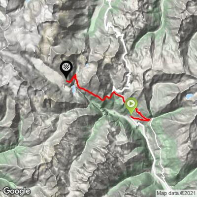
ROUTE MAP
MEMBER RATING
CURRENT WEATHER
PJAMM TRIPS ADVENTURE STARTER BUNDLES
Check out PJAMM Adventure's prepackaged (self-guided) cycling trips. They will help you plan, document and conquer your next adventure.
NEARBY CLIMBS (0) RADIAL PROXIMITY
FROM No Climbs Found
MEMBER REVIEWS & COMMENTS
Let us know what you thought of this climb. Signup for our FREE membership to write a review or post a comment.
Already have an account?
LOG IN HERE
