
23.6
PDI
9.1 mi
DISTANCE
3,558 ft
GAINED
7.4 %
AVG. GRADE
FULL CLIMB STATS
Page Contributor(s): Ian Dennis, Occidental, CA, USA
INTRO
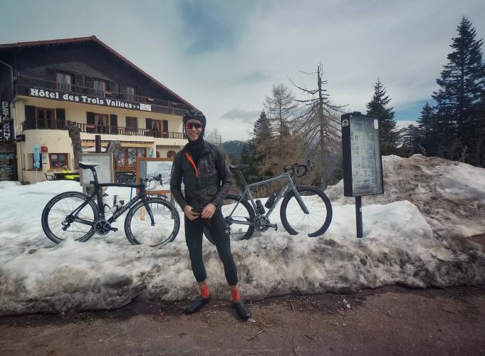
Col de Turini is the most famous road in the hills behind Nice, and this western approach from La Bollène-Vésubie is the side that made it famous: the Monte Carlo Rally's classic Turini stage climbs these same hairpins out of La Bollène every January. By bike it's 14.6 km (9.1 mi), gaining 1084 m (3,558 ft) at a 7.4% average to the col at 1607 m (5,272 ft).
After a gentle opening through the perched village of La Bollène-Vésubie, its tall pastel houses clustered around the church high above the valley, the grade settles into a remarkably steady 7-8.5% for the final 11 km, with barely a kilometer of relief. The upper half winds through a big conifer forest that keeps the sun off, and the stacked hairpins give the climb a smooth, almost metronomic rhythm.
The pros have raced it too: Paris-Nice finished atop Turini in 2019, when Daniel Felipe Martínez won the queen stage up this road and Egan Bernal took the race lead on his way to overall victory. The Tour de France has crossed the pass three times, in 1948, 1950 and 1973.
PLAN YOUR ROUTE
 We've partnered with Sherpa-Map.com to bring you the best route planning tool. With a PRO Membership you can use this climb as a reference when creating your route.
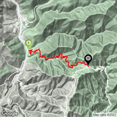
 The climb covers 14.6 km (9.1 mi) and gains 1084 m (3,558 ft) at an average of 7.4%.
The first 3 km, through La Bollène-Vésubie, are the easiest part of the climb: mostly 5-6% after a 7.5% opening kilometer. From about km 3 to the col, every kilometer averages between 6.8% and 8.5%, making this one of the most consistent climbs in the region - easy to pace, with no nasty surprises.
The steepest kilometer averages 8.4%, the steepest 5 km 8.0%, and the steepest 10 km 7.9%, and nothing tops about 9.6% even over short stretches.
Roadway: The M70 is paved the whole way and generally in good condition, with the well-built hairpins you'd expect from a rally stage. The forested upper section stays shaded and can be damp or icy in spring and autumn, and at 1607 m the col can see snow from late autumn into spring. The road closes to traffic during the Monte Carlo Rally stage each January.
Traffic: Light to moderate. Summer weekends bring motorcyclists and car enthusiasts making the rally pilgrimage, so expect some fast-moving traffic through the hairpins; weekday mornings are much quieter.
Parking: La Bollène-Vésubie, about 2 km into the climb, is the natural place to park and start if you don't need the full distance; for the complete climb, look for roadside space near the M70's junction with the M2565 in the valley and park considerately. There's a large parking area at the col by the hotels if you're being picked up at the top.
Provisions: La Bollène-Vésubie is the last village before the col, so fill bottles there - there's nothing along the forested middle of the climb. At the top, the hotels and restaurants at Col de Turini serve food and drinks in season.
Gear: Standard road gearing is fine for these steady 7-8% grades. The col sits more than 1000 m above the valley floor and is often noticeably cooler, so bring a layer for the descent, and check current conditions with our Weather tool before an early- or late-season ride.
Before heading out on any cycling adventure check out our Things to Bring on a Cycling Trip and use our interactive check list to ensure you don't forget anything.
The Vésubie valley was hit hard by Storm Alex in October 2020, when the floods cut La Bollène's access roads; the valley has been rebuilding ever since, and a coffee or lunch in La Bollène is a small, direct way to support it. The village is worth a wander: narrow lanes, fountains and a church square with views straight up toward the Turini forest.
From the col you have options the rally drivers don't. Continue on to La Forca (see our Col de Turini + La Forca page), take the dead-end road up to the Authion massif, dotted with old military forts and sweeping Alpine views, or head through Peïra-Cava and the Baisse de la Cabanette and descend to Lucéram for a loop back toward Nice. For the long southern approach from the Bévéra valley, see Col de Turini from Sospel.
ROUTE MAP
MEMBER RATING
CURRENT WEATHER
PJAMM TRIPS ADVENTURE STARTER BUNDLES
Check out PJAMM Adventure's prepackaged (self-guided) cycling trips. They will help you plan, document and conquer your next adventure.
NEARBY CLIMBS (0) RADIAL PROXIMITY
FROM No Climbs Found
MEMBER REVIEWS & COMMENTS
Let us know what you thought of this climb. Signup for our FREE membership to write a review or post a comment.
Already have an account?
LOG IN HERE
