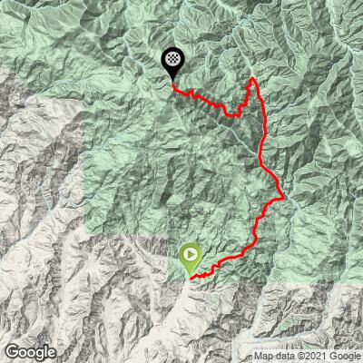
21.7
PDI
9.9 mi
DISTANCE
3,617 ft
GAINED
6.3 %
AVG. GRADE
FULL CLIMB STATS
INTRO
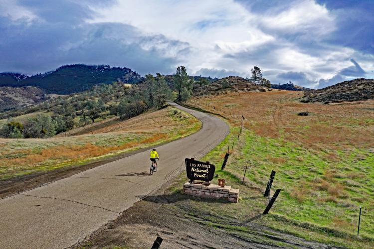
Both routes to the top of Figueroa Road, Santa Barbara County, are located almost entirely in Los Padres National Forest (established 1936 by Franklin D. Roosevelt; 1,950,000 acres). The Figueroa Mountain Recreation Area is within the Los Padres National Forest. Figueroa Mountain is part of the Santa Ynez Mountains, which are part of the Pacific Coast Range. This is a remote and peaceful ride.
PLAN YOUR ROUTE
The 6.3% average grade is very misleading. By removing descent from the gradient calculation, the average grade jumps to 7.9%. The one mile -6.7% descent beginning at mile three is the main offender in decreasing the average grade. 53% (5.2 miles) is at grades 5-10%, and 20% (1.9 miles) is at 10-15%. The steepest quarter-mile of the ride is 11.3% and there is a continuous mile averaging 9.9%.
See more details and tools regarding this climb's grade via the “Profile Tool” button.
Roadway: Good to rough but entirely paved as of 2019.
Traffic: Minimal.
Parking: The road is narrow with fencing along each side. There is a section wide enough to park about a third of a mile from the start of the climb - Map; Street View.
Provisions: None along the route.
Before heading out on any cycling adventure check out our Things to Bring on a Cycling Trip and use our interactive check list to ensure you don't forget anything.
Consider this climb as an out-and-back with Figueroa Mountain Road West - that makes the ride 39 miles with 7,400' of climbing (Map).
We have stayed in Buellton for our two times riding both sides of Figueroa Mountain Road and dined at the most famous pea soup-focused restaurant in the world (I love pea soup!) - Andersen's. Also consider staying in the very fun town of Solvang which is founded on Danish architecture and tradition (Solvang Home Page). There are many homes and villas to rent in the area too.
ROUTE MAP
MEMBER RATING
CURRENT WEATHER
PJAMM TRIPS ADVENTURE STARTER BUNDLES
Check out PJAMM Adventure's prepackaged (self-guided) cycling trips. They will help you plan, document and conquer your next adventure.
NEARBY CLIMBS (0) RADIAL PROXIMITY
FROM No Climbs Found
MEMBER REVIEWS & COMMENTS
Let us know what you thought of this climb. Signup for our FREE membership to write a review or post a comment.
Already have an account?
LOG IN HERE
Ian.O
Underused and underrated. This climb is one of the best in the state. There are about 6 different environments you go through on this climb and all of them are beautiful. Start in Solvang, climb this and then continue for a loop and add on Ballard Canyon road at the end to bring you back. The road quality is all over the place; some sections are very smooth and others have cattle guards and uneven terrain and there is even a mile of light gravel (easily doable on a road bike with 25s). You have a good chance of not seeing a single car if you come during the week. Bring plenty of water-it can get very hot in the canyon leading up to Sunset Valley road.