Figueroa Mountain Road West Bike Climb - PJAMM Cycling

6.5
FIETS
9.5 mi
DISTANCE
3,389 ft
GAINED
6.2 %
AVG. GRADE

FULL CLIMB STATS

INTRO

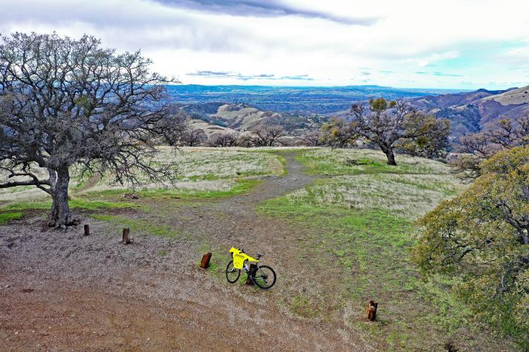
Cycling Figueroa Mountain Road West - a very nice bike climb into Las Padres National Forest with great views of the Santa Ynez Mountains.
Average grade is 6.1% (8.1% climb only).  The grade is all over the map on this climb - 17% is descent, 16% is at 0-5% grade, 38% is at 5-10%, 27% is at 10-15%, and 2% is at 15-20% grade.  The steepest quarter-mile is 14.4% and steepest mile 10.3%.

See more details and tools regarding this climb's grade via the “Profile Tool” button.
Roadway:  Two lane road (narrows to one lane at points near the top) in fair to good condition with no center striping or shoulder.

Traffic:  Minimal.

Parking:  On the right side of the road just before the start (MapStreet View). 
Provisions:  None on this remote climb.  The closest food and beverages are in Los Olivos seven miles south (Map).
Before heading out on any cycling adventure check out our Things to Bring on a Cycling Trip and use our interactive check list to ensure you don't forget anything.
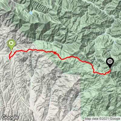
Consider this climb as an out-and-back with Figueroa Mountain Road South - that makes the ride 39 miles gaining 7,250' (Map).

We have stayed in Buellton for our two times riding both sides of Figueroa Mountain Road and dined at the most famous pea soup-focused restaurant in the world (I love pea soup!) -  Pea Soup Andersen's. Also consider staying in the very fun town of Solvang which is founded on Danish architecture and tradition (Solvang Home Page).  There are many great houses and villas to rent in the area too.

ROUTE MAP

MEMBER RATING

Difficulty: Strenuous
3
Road
5
Traffic
4
Scenery

CURRENT WEATHER

PJAMM TRIPS ADVENTURE STARTER BUNDLES

Check out PJAMM Adventure's prepackaged (self-guided) cycling trips. They will help you plan, document and conquer your next adventure.
ALL TRIPS
Browse all of our prepackaged trips and find your next adventure!

NEARBY CLIMBS (0) RADIAL PROXIMITY

FROM
No Climbs Found

MEMBER REVIEWS & COMMENTS

Let us know what you thought of this climb. Signup for our FREE membership to write a review or post a comment.
Already have an account?

Jun 6, 2021
difficulty: Strenuous
scenery: 4
traffic: 5
road: 3
Jun 6, 2021
scenery: 4
traffic: 5
road: 3
Great backcountry climb. First few kilometers are a serious wake up call. Can be tricky water crossings in winter.1 Mile gravel section. 40 miles if you do whole loop, maybe you'll see a few cars. Tough climb but well worth it.
ROUTE MAP
PROFILE TOOL
Route Data
S.G. (%)
hide
Segment Data
hide

Climb Profile Not Found
CLIMB SUMMARY

Climbing Figueroa Road by bike - Los Padres National Forest sign and road.

Climbing Figueroa Road West in Los Padres National Forest

Both routes to the top of Figueroa Road, Santa Barbara County, are located almost entirely in Los Padres National Forest (established 1936 by Franklin D. Roosevelt; 1,950,000 acres).  The Figueroa Mountain Recreation Area is within the Los Padres National Forest.  Figueroa Mountain is part of the Santa Ynez Mountains which are part of the Pacific Coast Range.

 The climb up Figueroa West is similar to the Southern approach, although the views on this segment are primarily to the south (Santa Ynez Valley), while the Western approach offers a bit broader view radius (primarily north, south and west).  The sustained pitches on this climb are slightly more challenging than the southern approach (several sections with grades between 8-15% - see elevation profile, below) - this is a very challenging and rewarding climb.  We rode most of this climb in the rain which dampened our views, but as you can see from the video and photographs, this is a climb you will appreciate and certainly not regret. Much of the climb from both approaches is through the Los Padres National Forest.

Bicycle climb on Figueroa Mountain Road West - Start of climb and cattle warning sign

Start of climb on Figueroa Mountain Road

Cycling Figueroa Mountain Road west - Los Padres National Forest sign

Enter National Forest at mile 3.1

Bike climb on Figueroa Mountain Road West - photo of road and Santa Ynez Mountains.

Wide open views on this climb

Very narrow road.


Roadway surface and Traffic: The first 3 miles of this climb are on rough roadway which smooths out considerably once we enter
Los Padres National Forest just after the 3 mile mark.  As with Figueroa South, the road is essentially one lane, but there is minimal traffic and this is a safe and isolated climb.

Snow is not infrequent at the higher point of the climb during the winter.