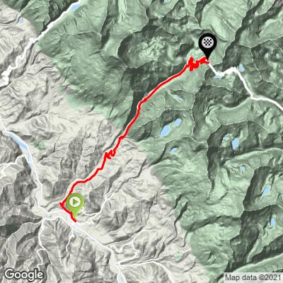
Punta Olimpica Bike Climb - PJAMM Cycling

45.3
PDI
28.9 mi
DISTANCE
6,958 ft
GAINED
4.5 %
AVG. GRADE

FULL CLIMB STATS

Page Contributor(s): Ties Arts, Bussum, Netherlands; Bryan Kevan (BMK Framewerckx), Berkeley, California; Jelmer Brinkman,Lent, Netherlands

INTRO

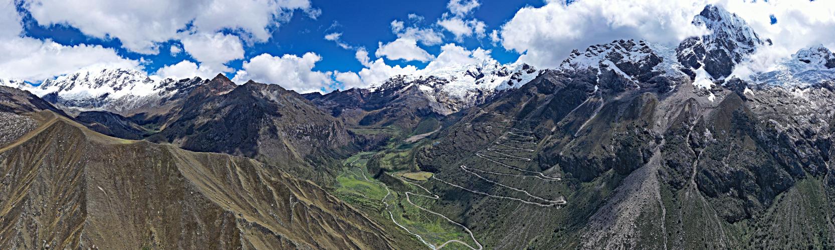
The Punta Olimpica road bike climb is in our opinion the second most epic bike climb in the world.  There are so many factors that make this one of the greatest bike climbs on earth - challenging, stunningly scenic, glaciers, lakes, high altitude (finish at  4,736 meters/15,538’), hairpins, etc., etc. 

While you're there, you can't miss the other side of the tunnel, Punta Olimpica East. It's every bit as epic!
This climb averages 4.5%. The steepest quarter mile of this climb is 13.9% and steepest continuous mile is 8.1%. 1 miles of the climb is at or above 10% grade. The gradient on this climb is broken down as follows: 1.3 miles (4.7%) of descent; 15.8 miles (54.7%) at 0-5% grade; 10.7 miles (37.3%) at 5-10% grade; 0.9 miles (3%) at 10-15% grade; 0.1 miles (0.4%) at 15-20% grade;

See more details and tools regarding this climb's grade via our interactive Profile Tool.

When you reach the town of Shilla, there's a .2 mile section averaging 15% (our Wahoo read as high as 19%). Ever wonder what biking up 19% feels like at 10,000 feet above sea level? It hurts!
Roadway & Traffic:
This is a well maintained national park road, and the surface is excellent. Traffic is mainly tourists driving around the park and very light. 
You'll have to pay the national park fee to complete the second half of this climb. 

Parking:
There is street parking at the start of the climb. We used a SAG who drove along with us and didn't have to park (which we recommend). 
Gear:
As you can assume from the altitude, these climbs can get very, very cold at the top. When riding this high in the mountains, rain and snow storms can formulate and appear at a moments notice.  Make sure you bring sufficient cold gear and an emergency rain jacket, even if it's warm and sunny when you start!

Provisions:
There are places to get water and snacks in the Shilla District at mile 6, and restrooms, a restaurant, and vending machine at the park entrance at mile 14. 
Before heading out on any cycling adventure check out our Things to Bring on a Cycling Trip and use our interactive check list to ensure you don't forget anything.
We stayed in Huaraz, about 90 minutes from the start of the climb. We highly recommend where we stayed at La Casa de Zarela, an excellent bed and breakfast with incredibly warm and friendly hosts.

If doing this climb again, we'd probably choose to stay in Carhuaz right at the start. It is a very hard climb to get to, but without a doubt the highlight of a Peruvian cycling trip. All of the climbs in central Peru require a good amount of driving to get to, regardless of where you're staying.

ROUTE MAP

MEMBER RATING

Not Yet Rated
-
Road
-
Traffic
-
Scenery

CURRENT WEATHER

PJAMM TRIPS ADVENTURE STARTER BUNDLES

Check out PJAMM Adventure's prepackaged (self-guided) cycling trips. They will help you plan, document and conquer your next adventure.
ALL TRIPS
Browse all of our prepackaged trips and find your next adventure!

NEARBY CLIMBS (0) RADIAL PROXIMITY

FROM
No Climbs Found

MEMBER REVIEWS & COMMENTS

Let us know what you thought of this climb. Signup for our FREE membership to write a review or post a comment.
Already have an account?
ROUTE MAP
PROFILE TOOL
Route Data
S.G. (%)
hide
Segment Data
hide

Climb Profile Not Found
CLIMB SUMMARY

Panoramic views of mountain peaks covered in snow, sharp mountain road snaking up mountainside

Cycling Punta Olimpica, Peru - one of world’s most epic bike climbs.

Ride 52 kilometers gaining 2,327 meters at 4.3% average grade.

Climb summary by PJAMM founder John Johnson.

photo collage; PJAMM Cycling logo in corner, bike parked next to red sign for Parque Nacional Huascaran; PJAMM Cyclist rides with snowy mountain peaks in front of him

After the Death Road, this is the most epic bike climb I have ever ridden.  What makes this climb so outstanding is it’s scenery, challenge, hairpins, glaciers, and finish at one of the highest paved roads in South and North America. The climb finishes in Parque Nacional Huascaran, a Peruvian national park and UNESCO World Heritage Site.

PJAMM Cyclist rides on roadway past large boulder in middle of road

Generally, the grade is mild on this climb, although there is a brief steep stretch at mile 17 in the village of Llipta.

Photo collage shows Carhuaz, Peru, climb start, large white sign over roadway, cyclist rides behind donkeys on road in town

Climb begins in Carhuaz, Ancash Region of Peru.

We stayed in Huaraz (population ~120), a hub for hiking and climbing in the Cordillera Blanca Mountains which are near the town.  This mountain range is part of the Andes Mountains, and includes several peaks over 6,000 meters (almost 20,000 feet), along with 722 individual glaciers.  This is a beautiful and awe inspiring area.

One could also consider staying in Carhuaz (population ~7,000) which is the start of our climb. Carhuaz is the capital of Peru’s Carhuaz province.  The town’s name means “yellow,” which is the color of the broom flowers that cover the hillsides in season.

Photo collage shows women wearing brightly colored Peruvian clothing walking with their sheep and donkeys through town

This is a rural climb through farm and grazing land some of the way.

photo collage shows large break in roadway where cars cannot pass; PJAMM cyclist stands with bike past roadway break

As of December 2021, you will need to hop a creek to follow the standard route to Punta Olimpica. The SAG vehicle would take the dirt road on the right a few hundred yards before the river; that road connects with the main road after a mile or two - beware the dirt road is very narrow.  Here is the bypass of the river along the dirt road.

Village of Llipta, miles 5 through 8, sheep in roadway, scenic landscape

Views on the way to and passing through the small village of Llipta at around miles 5-8.

Photo collage shows the elevation gaining on miles 8 through 11, PJAMM Cycling logo in corner

Photos from miles 8 to 11.

aerial views of two sets of hairpin turns in the roadway, shortly before entering national park

There are a couple sets of hairpins before we enter the park around mile 13.

photo collage, first set of hairpins before entering the national park, mile 12

First set of hairpins - mile 12, before entering the park.

two PJAMM Cyclists stand and smile with their bikes in front of bright red sign announcing entrance to National Park: Parque Nacional Huascaran

Entering the national park at mile 13.2.

This Peruvian national park was established in 1975 and consists of 340,000 acres.  The park is in the Cordillera Blanca, the world’s highest tropical mountain range, which extends about 200 miles and is part of the Andes range. There are over 700 glaciers in these mountains, most of them in Huascaran National Park.  

photo collage shows informational signs and the entrance to Huascaran Nacional Park

Huascarán National Park was designated a UNESCO World Heritage Site in 1985.

“Situated in the Cordillera Blanca, the world's highest tropical mountain range, Mount Huascarán rises to 6,768 m above sea-level. The deep ravines watered by numerous torrents, the glacial lakes and the variety of the vegetation make it a site of spectacular beauty. It is the home of such species as the spectacled bear and the Andean condor”  (read more here).

Photo collage shows views of the green Ulta Valley, surrounded by tall mountain faces, blue sky and white clouds

Ulta Valley.

This glacially formed valley reminds me of the eastern entrance to Yosemite National Park and the meadows of Yellowstone National Park, both with meandering waterways (Yellowstone River and meadows is remarkably similar).  This valley is simply stunning and the entrance to a spectacular climb through hairpins in sight of some of the most scenic and highest peaks in Peru.

aerial view shows panoramic views of narrow valley tucked between two giant mountain sides

Aerial view from the beginning of the major hairpins at mile 19 looking southwest.

photo collage shows PJAMM Cyclist riding up the hairpins, Ulta Valley behind

Sam rides up the hairpins with Ulta Valley as a backdrop.

photo collage shows views of the Ulta Valley, as well as a small glacial valley in the north of the mountains

Views of the Ulta Valley and of a small glacial valley to the north (photos upper middle and right).

photo collage, cattle, glacial runoff

Signs and cattle at the beginning of the hairpins at mile 19.

29 hairpins over a nine mile segment.

photo collage, aerial view shows PJAMM Cyclist climbing up hairpins in roadway, view looking down at the hairpins stacked atop each other on mountainside

photo collage, PJAMM Cyclists climb up mountain roadways, brightly colored tour bus also climbs up roadway

photo collage, PJAMM Cycling logo in corner, PJAMM Cyclist rides against bright white background of clouds and the snow covered face and peak of Chopicalqui Mountain

Views of the amazing Chopicalqui Mountain.

At 6,354 meters (20,846 feet) above sea level, Chopicalqui is one of the highest peaks in the mountain range.  Huascaran National Park is situated in the Cordillera Blanca, or the “White Mountains”, and the photos above make it clear how the mountain range got its name!  Chopicalqui is a challenging favorite for snow hikers.

Aerial drone view of the huge set of hairpin turns, consisting of 7.3 miles at 5.2% grade, topping out at 15,514 feet

The main concentration of hairpins - 7.3 miles at 5.2% beginning at mile 21, topping out at 15,514’.

Because of the altitude (15,000’), the configuration, and the surrounding scenery, this is one of the greatest sets of hairpins in the world.  

Aerial drone view of the huge set of hairpin turns, consisting of 7.3 miles at 5.2% grade, topping out at 15,514 feet

Nevado Ulta mountain seen from the top of the hairpins

Nevado Ulta as seen from the upper hairpins of the Punta Olimpica climb.

Nevado Ulta is another Cordillera Blanca mammoth of a mountain, this one topping out at 5,875 meters (19,275 feet) above sea level.

photo collage shows aerial views of Laguna Chacllacocha, a small bright blue lake nestled into the side of the mountain, also seen is a glacier

We ride in sight of and towards the glacier just above Laguna Chacllacocha over the last third of the climb.

There are 600 glaciers and nearly 300 lakes in Huascaran National Park.

Photo collage, PJAMM Cyclist John Johnson rides on mountain roadway looking out over Nevado Poroguingua mountain, views of the snow covered mountain face, PJAMM Cycling logo in corner

Nevado Poroguingua - 18,805’.

two photos of small dogs, one a hairless, mangy dog, and the other a small brindled dog with a green collar

Beware of dogs on all bike rides into the mountains of Peru.  We did not have any close encounters on Punta Olimpica, but there are many unleashed dogs along paved roads in Peru and they can be vicious - we recommend bringing a stick or club to hold above your head to deter dog attacks - this worked for us except on one occasion on Punta Callan.

photo collage, PJAMM Cyclists smile in roadway in front of tunnel, PJAMM Cyclists ride toward finish of climb, snow covered mountain peaks in front of them, sticker covered sign, views of hairpins, PJAMM Cycling logo in corner

Photos of and near the finish of the climb.

Bottom center photo - finish just around the corner, top left.

photo collage shows climb finish at the Punta Olimpica Tunnel, one of the highest cycling finishes in the Americas

Finish 15,538’

One of the highest paved cycling finishes in the Americas.

The Punta Olimpica tunnel is said to be the highest tunnel in the world.

two photos of PJAMM photographer, Javier Chacon, standing and smiling with camera in front of hairpin turn, and sitting in zen pose in roadway, mountains behind him in both photos

Our dear friend and photographer Javier Chacon of Bogota, CO.