
22.7
PDI
14.2 mi
DISTANCE
4,327 ft
GAINED
4.8 %
AVG. GRADE
FULL CLIMB STATS
INTRO
Col de Creu climbs 22.8 km (14.2 mi) from Olette in France's Pyrénées-Orientales, gaining 1319 m (4,327 ft) at an average grade of 4.8% to a forested pass of about 1710 m (5,610 ft) that links the Conflent with the high Capcir plateau. The modest average hides a climb of three distinct parts: a firm opening out of the Têt valley, a long, rolling middle section, and a much steeper finish above the tiny village of Railleu.
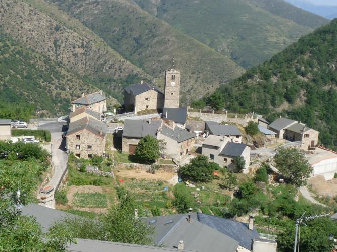
What sets this climb apart is how wild and empty it feels. The narrow road is cut into the mountainside above deep, dry valleys, with long drops off the edge for much of the way. It threads through the Garrotxes, a small, sparsely populated corner of the Conflent whose few villages cling to the slopes; Railleu, around km 17, has a year-round population of about 20. Cars are rare enough that you may have the road almost to yourself.
The character changes after Railleu. The road narrows further, the surface gets grainier, and the final kilometers bring ramps above 10% - often into a stiff headwind on the exposed slopes - before a last hairpin delivers you to the col among the trees. From the top, the road drops the other way toward Matemale and the lakes and pine forests of the Capcir.
PLAN YOUR ROUTE
 We've partnered with Sherpa-Map.com to bring you the best route planning tool. With a PRO Membership you can use this climb as a reference when creating your route.
 From Olette at 630 m (2,066 ft), the climb covers 22.8 km (14.2 mi) with 1319 m (4,327 ft) of total climbing at an average of 4.8%, including about 227 m (745 ft) of descending along the way.
The first 5 km (3.1 mi) are the steadiest climbing of the lower half, averaging close to 6%, with one kilometer near 9%. From there the middle 12 km (7.5 mi) roll gently - several kilometers average 3% or less, and a few short dips give you a breather - so this is the place to eat, drink, and save something for later.
The real work starts after Railleu, around km 17. Kilometers 20 through 22 each average between 7.3% and 7.5%, and short pitches go well into double digits. The steepest kilometer averages 8.6%, the steepest 0.5 km 10.4%, the steepest 2 km 7.9%, and the steepest 5 km 6.8%.
Roadway: The road is paved the entire way, but it's a narrow, often single-lane mountain road with a coarse, grainy surface, and riders regularly report loose gravel - particularly on the approach to Railleu and on the narrow final kilometers above it. Much of the lower and middle road runs along the cliffside with long drops below, so take the descent with care. This is high country, so plan on riding it between late spring and autumn.
Traffic: Very light - this is one of the quietest paved climbs in the eastern Pyrenees. The road serves only a handful of tiny villages, and riders consistently describe it as deserted, with long stretches where you won't see a single car.
Parking: Park in Olette near the village center, right at the start of the climb. If you'd rather leave the car at home, the Olette - Canaveilles-les-Bains stop on the Train Jaune (the narrow-gauge Little Yellow Train of the Cerdagne line) is in the heart of the village.
Provisions: Stock up in Olette before you start - there's nowhere to buy food on the climb itself. Railleu, around km 17, has a water fountain for a last refill before the hardest part of the climb. If you're linking this with the Col de la Llose, there's a relais (refreshment stop) at the Llose pass.
Gear: Standard compact gearing is plenty, since no full kilometer averages more than about 9%. Pack a windproof layer - the upper slopes are exposed and the wind is frequently in your face on the final kilometers - and carry two full bottles on hot days, as the lower valleys are dry and offer very little shade. Wider tires with a little extra grip are worth considering for the gritty, gravel-dusted surface on the way back down.
Before heading out on any cycling adventure check out our Things to Bring on a Cycling Trip and use our interactive check list to ensure you don't forget anything.
Railleu is one of the four villages of the Garrotxes, a remote pocket of the Conflent north of the Têt valley where a few tiny villages cling to the slopes. Neighboring Sansa, reached by a short, pretty side road near the top of the climb, is a worthwhile detour if you have the legs.
Over the col, the road drops onto the Capcir, a high plateau of pine forest and meadows around the Lac de Matemale - a completely different landscape from the arid gorges you climbed through, and a good place to extend the ride. A road link near the top also connects toward the Col de la Llose, so you can link the two cols in a big loop out of Olette (our Olette to Col de la Llose page covers that climb and the village of Olette in more detail).
Olette is a good base for several other climbs in the Conflent - see what else is nearby, or build a custom route from here, with our Routes in the Area tool.
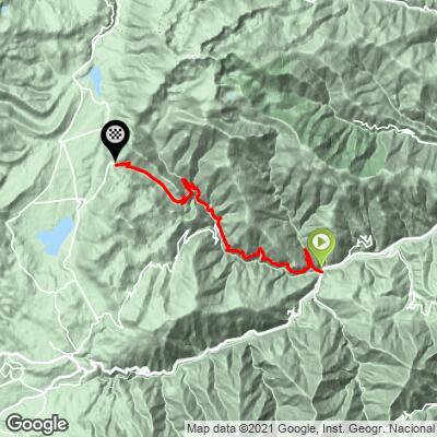
ROUTE MAP
MEMBER RATING
CURRENT WEATHER
PJAMM TRIPS ADVENTURE STARTER BUNDLES
Check out PJAMM Adventure's prepackaged (self-guided) cycling trips. They will help you plan, document and conquer your next adventure.
NEARBY CLIMBS (0) RADIAL PROXIMITY
FROM No Climbs Found
MEMBER REVIEWS & COMMENTS
Let us know what you thought of this climb. Signup for our FREE membership to write a review or post a comment.
Already have an account?
LOG IN HERE
