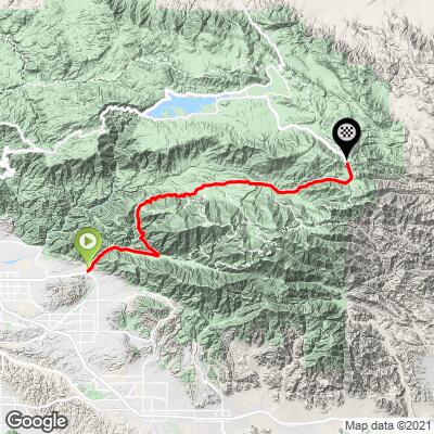
Onyx Summit Bike Climb - PJAMM Cycling

7.9
FIETS
30.3 mi
DISTANCE
6,666 ft
GAINED
3.6 %
AVG. GRADE

FULL CLIMB STATS

INTRO

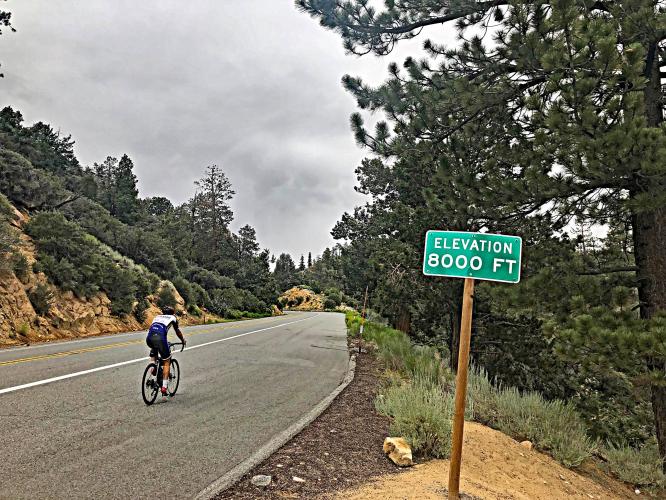
At 30.4 miles Onyx Summit is the second longest bike climb in California, and eighth longest in the US.  We also gain more elevation (6,734') on this climb than all but four others in the state.   For most of the climb we are in an alpine setting on one of the routes to popular Bear Mountain Ski Resort.
 Average grade is 3.6% (5.1% climb only).  18% of the climb is descent, 38% 0-5% grade and 42% 5-10%.  The steepest quarter mile is 11.2% and mile 7.3%.

See more details and tools regarding this climb's grade via the “Profile Tool” button.
Roadway:  Good condition with a very wide shoulder for the first half of the climb, narrowing to a moderately wide, but existent shoulder during the second half. 

Traffic:  Can be moderate to heavy.

Parking:  Park at the climb start at the Mill Creek Visitor Center - Map; Street View.
Provisions:  There are plenty of food and beverages at The Oaks restaurant and Country Store just off the road in Angeles Oaks at mile 11, otherwise there are no provisions on this 30 mile ride: Google Map + Reviews; Street View

Gear:  Consult the PJAMM "Full Forecast" feature for the time you expect to arrive at the finish to assess what clothing to bring on your ride. We have ridden this route during early winter and encountered a fair amount of snow at higher elevations.  Be aware that since you finish this ride nearly 6,000' above your start elevation, and above 8,000', the conditions can be much windier and colder at finish than start. 
Before heading out on any cycling adventure check out our Things to Bring on a Cycling Trip and use our interactive check list to ensure you don't forget anything.
Also consider riding the shorter Highway 38 - Valley of the Falls if you have travelled to the Redlands area to climb by bike.  

There are many options for both hotels and vacation rentals in the area.

Use the “Routes in Area” button on the menu bar above to see other bike climbs in this area. 

ROUTE MAP

MEMBER RATING

Difficulty: Strenuous
4
Road
3
Traffic
4
Scenery

CURRENT WEATHER

PJAMM TRIPS ADVENTURE STARTER BUNDLES

Check out PJAMM Adventure's prepackaged (self-guided) cycling trips. They will help you plan, document and conquer your next adventure.
ALL TRIPS
Browse all of our prepackaged trips and find your next adventure!
San Gabriel Mountains
United States (CA)
38 ROUTES
43 POIs
ROUTE STATS (TOTAL)
677.5
mi
DISTANCE
80,483
ft
ELEV. GAIN

NEARBY CLIMBS (0) RADIAL PROXIMITY

FROM
No Climbs Found

MEMBER REVIEWS & COMMENTS

Let us know what you thought of this climb. Signup for our FREE membership to write a review or post a comment.
Already have an account?

May 21, 2021
difficulty: Strenuous
scenery: 4
traffic: 3
road: 4
May 21, 2021
scenery: 4
traffic: 3
road: 4
Long but beautiful climb right outside LA. After the first mile, the shoulder opens up, and you continue to climb until Angelus Oaks. Then there are about 10 miles of rolling, not to strenuous climbing in a beautiful alpine setting. Then it finishes with about 5 miles of climbing up to the summit. There is no sign at the summit, but you will know when you get there! Traffic is medium, but much of it is very fast-moving. It can be very cold and windy at the top so bring some arm warmers and gloves! Mill Valley Ranger station is closed right now, but the parking lot is still open to park in.
ROUTE MAP
PROFILE TOOL
Route Data
S.G. (%)
hide
Segment Data
hide

Climb Profile Not Found
CLIMB SUMMARY

Climbing Onyx Summit by bike - aerial drone view of Onyx Summit bike climb

Cycling Onyx Summit - this is the second longest bike climb in California, #9 US, #29 World.

Ride an amazing 30.5 miles gaining 7,328’ to peak elevation of 8,450 at 3.6%.

Before heading to Southern California for your cycling adventure, be sure to rely on our list of Things to Bring on a Cycling Trip, and use our interactive checklist to ensure you don't forget anything.

Cycling Onyx Summit, California - photo collage, NPS sign for Mill Creek Visitor Center, San Bernadino National Forest, elevation signs, Onyx Summit road sign, snow at summit,  PJAMM Cycling logo in corner

Climb summary by PJAMM’s John Johnson.

Onyx Summit is the longest and highest Southern California climb and quite a challenge.   We have climbed Onyx during the spring of 2011 and 2012 for the super century “Breathless Agony” organized ride and once in late November 2015.  The climb can be quite hot during the late spring and summer and quite cold and stormy during the late fall and winter months.  The first two climbs were uneventful and very manageable with excellent support provided by the Breathless Agony organizers.  The climb in late November (as can be seen from the slideshow above) was quite the adventure .  

Tip: Park at the U.S. Forest Service Mill Creek Visitor Center (corner of Bryant Street and Hwy 38)

 Start of Onyx summit bicycle climb - San Bernardino National Forest sign and visitor center entrance.   

  Start of Onyx Summit climb by bike - flower and National Forest sign.

For the first 6 miles we climb through Mill Creek Canyon and the views east up the Canyon are good.  

park at the U.S. Forest Service Mill Creek Visitor Center (corner of Bryant Street and Highway 38).

Riding bike through canyon at start of Onyx Summit bicycle climb.   

  Two lane highway roadway with large stone wall

At mile six, we take a sharp left at the junction of Highway 38 and Valley of the Falls Road and begin our climb in earnest up towards Onyx Summit.

Cycling up Highway 38 to Onyx Summit  - cyclist and road sign to Valley Falls     

aerial drone view shows hairpin turn at the Valley of Falls exit

Hairpin at Valley of Falls exit.

We continue up the mountain to Onyx Summit.


For miles 7-10 we have some excellent views to the west  (our left) back towards Mentone and Redlands far below.  At mile 11 we have the opportunity to enjoy a quick snack at The Oaks Restaurant (we suggest stopping here for a full meal on the way down - try the bacon cheeseburger and apple pie - you can't go wrong there!).  

 Biking up Hwy 38 to Onyx Summit  - The Oaks Restaurant sign and parking lot.

Nice place to eat at mile 11.5 in Angelus Oaks. 

Onyx Summit bike ride - summit sign, snow

Mile 30.5.


We are surrounded by the
San Bernardino National Forest for the remainder of our climb.  There is 750' of descent along the long rollers and two long descents over the final 20 miles until we top out at Onyx Summit at 8,443', according to the summit sign.

photo collage, PJAMM Cyclists climb Onyx summit in snow storm 

Southern California conditions . . .

   . . . in NOVEMBER!

Traffic to Big Bear was heavy and the road was pitched towards the center in

spots making the going truly treacherous.  Well, that’s our excuse anyway -

we bailed three miles shy of the summit.


Roadway Surface and Traffic Report:  The roadway is excellent.  Traffic is moderate to heavy, in our experience.  During our May climbs in 2011 and 2012, traffic was light to moderate while it was moderate and fast moving for the first six miles on our way up to Valley of the Falls in Fall 2014.  Traffic on a snow day (why were we riding then?! - good question!) the day after Thanksgiving in 2015 was extremely heavy and fast moving.

Access to full Climb Summary requires a PJAMM Cycling PRO Membership!

It takes less than a minute to sign up & with your PRO membership you can:
  • Rate climbs, post comments and share your experiences on any of our climb pages
  • Create bucket lists of climbs & mark the dates you complete them
  • Weather data for all climbs - Start & Finish
  • Upload photos to your member page to customize your PJAMM Cycling experience
  • Utilize all of our interactive tools - Profile & Routes in Area
  • Download climb route .gpx files
LEARN MORE
SIGN UP

Already have an account? LOG IN HERE