
19.8
PDI
10.2 mi
DISTANCE
3,335 ft
GAINED
6.1 %
AVG. GRADE
FULL CLIMB STATS
INTRO
PLAN YOUR ROUTE
 We've partnered with Sherpa-Map.com to bring you the best route planning tool. With a PRO Membership you can use this climb as a reference when creating your route.
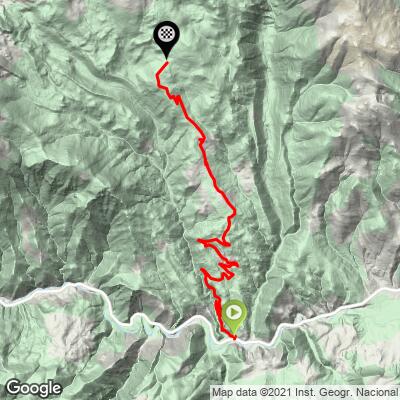
Martinet-Lles climbs 16.4 km (10.2 mi) and gains 1,017 m (3,335 ft) at a 6.1% average, from 966 m (3,170 ft) to 1,955 m (6,415 ft).
The grade splits cleanly around Lles de Cerdanya, which you reach at about 9.5 km (5.9 mi). The lower half averages roughly 5.3% and includes a flat stretch above Travesseres; the upper half, about 6.9 km (4.3 mi), averages roughly 7.0%.
The steepest 100 m (0.1 mi) hits 15.0% and the steepest quarter-mile 11.7%. The steepest 0.5 km averages 11.5%, the steepest kilometer 9.6%, the steepest 2 km 8.7% and the steepest 5 km 7.9%, while the steepest 10 km still averages 6.8%. The hardest sustained effort, about 1.5 km at around 10%, comes near the 13 km mark.
Roadway: The LV-4036 is paved up to the Cap del Rec ski area, with decent asphalt through the lower valley and a rougher surface above Lles, where gaps and patches call for careful line choice. A cattle grid near the top marks the end of the tarmac - the final stretch is unpaved, and the gravel track beyond it continues toward the Estanys de la Pera, which is mountain bike terrain rather than road bike terrain.
Traffic: Light. The road dead-ends at the ski area, so there is no through traffic - mostly local vehicles and visitors heading for the villages and the Cap del Rec refuge.
Parking: Martinet is the commercial center of the area, with a weekly Monday market, so park in the village and roll the short distance to the start on the N-260. Our Coll d'Estana and Desvio Aransa - El Fornell climbs start from the same village, so one parking spot covers all three.
Provisions: Water is available in Martinet, Travesseres and Lles, and the Cap del Rec refuge at the top has a restaurant, a cafeteria-bar and a terrace and is open all year. Top up your bottles in Lles before the final 6.9 km (4.3 mi).
Gear: The finish is roughly 1,000 m (3,300 ft) higher than the start, so pack a windproof layer for the summit and the descent even on a warm valley day. Slightly wider tires (28 mm or more) help on the rough pavement above Lles, and a 32- or 34-tooth cog makes the upper half more comfortable.
Before heading out on any cycling adventure check out our Things to Bring on a Cycling Trip and use our interactive check list to ensure you don't forget anything.
Martinet is the main service village of this corner of the Baixa Cerdanya, with the area's shops, bank and health services, and it sits on the N-260, the road to Puigcerdà, the valley's hub and home to the Cerdanya tourist office. Up the climb, Lles de Cerdanya (about 1,480 m / 4,860 ft) has the parish church of Sant Pere, and the hamlets of Músser, Arànser, Viliella and Coborriu de la Llosa are all part of the same municipality.
In Martinet's own municipality, the Parc dels Búnquers de Montellà i Martinet preserves part of the 1940s "Line P" defensive line of the Pyrenees, with a guided visit through eight restored fortifications that lasts about 1 hour 45 minutes - call 648 14 10 70 to check times.
At the top, the Cap del Rec refuge sits on the GR 11 and offers beds, a restaurant and bike storage. Beyond it, roughly 11 km (6.8 mi) of gravel track leads to the Estanys de la Pera, a classic mountain bike outing. Conditions at almost 2,000 m (6,500 ft) can differ a lot from the valley floor, so check our Weather tool before you head up.
ROUTE MAP
MEMBER RATING
CURRENT WEATHER
PJAMM TRIPS ADVENTURE STARTER BUNDLES
Check out PJAMM Adventure's prepackaged (self-guided) cycling trips. They will help you plan, document and conquer your next adventure.
NEARBY CLIMBS (0) RADIAL PROXIMITY
FROM No Climbs Found
MEMBER REVIEWS & COMMENTS
Let us know what you thought of this climb. Signup for our FREE membership to write a review or post a comment.
Already have an account?
LOG IN HERE
