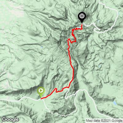
Mt. Lassen South Bike Climb - PJAMM Cycling

17.7
PDI
16.6 mi
DISTANCE
3,627 ft
GAINED
4 %
AVG. GRADE

FULL CLIMB STATS

Page Contributor(s): John Berude, Berkeley, CA

INTRO

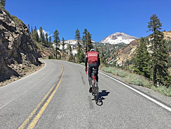
We begin this climb in the tiny Northern California town of Mineral (population 120), climbing northeast on Highway 36 into Mt. Lassen Volcanic National Park
Average grade is 4% (4.5% climb only).  54% of the climb is at 0-5% grade and 38% is at 5-10%.  The steepest quarter-mile is 7.4% and steepest mile 6.4%.

See more details and tools regarding this climb's grade via the “Profile Tool” button.
Roadway:  Two line roadway in good condition with a double yellow center stripe and no to narrow shoulder. 

Traffic:  Mild. 

Parking:  At the Visitor Center and then ride 10 miles down to the start and begin the climb from there, or at a big paved area on the side of the road at the start of the climb (MapStreet View). 
Provisions:  At the Mineral Grocery Store at the start of the climb (Map).
Before heading out on any cycling adventure check out our Things to Bring on a Cycling Trip and use our interactive check list to ensure you don't forget anything.
Visit the Kohm Yah-mah-nee Visitor Center at mile 10 at before, during, or after your climb (MapStreet View).  Visit the National Park while you are in the area (Official Website).   The top climbs in the national park are #1 Lassen Peak and #2 Bumpass Hell Trail.  See All Trails - Top Mt. Lassen Trails for more information. 

Consider doing this climb together with Mt. Lassen North as an out-and-back - 67 miles gaining 6,910' (Map). 

ROUTE MAP

MEMBER RATING

Difficulty: Moderate
4
Road
3.5
Traffic
3.5
Scenery

CURRENT WEATHER

PJAMM TRIPS ADVENTURE STARTER BUNDLES

Check out PJAMM Adventure's prepackaged (self-guided) cycling trips. They will help you plan, document and conquer your next adventure.
ALL TRIPS
Browse all of our prepackaged trips and find your next adventure!

NEARBY CLIMBS (0) RADIAL PROXIMITY

FROM
No Climbs Found

MEMBER REVIEWS & COMMENTS

Let us know what you thought of this climb. Signup for our FREE membership to write a review or post a comment.
Already have an account?

Aug 21, 2023
difficulty: Moderate
scenery: 4
traffic: 4
road: 4
Aug 21, 2023
scenery: 4
traffic: 4
road: 4
Great ride all around. I did it in the evening on a weekday and August, so I had pretty minimal traffic. Beautiful once you get into the park, and really not too challenging.
Apr 8, 2021
difficulty: Moderate
scenery: 3
traffic: 3
road: 4
Apr 8, 2021
scenery: 3
traffic: 3
road: 4
This is the more scenic side of Lassen, but it also has more traffic. The sulphur vents are an interesting experience on a bike!
ROUTE MAP
PROFILE TOOL
Route Data
S.G. (%)
hide
Segment Data
hide

Climb Profile Not Found
CLIMB SUMMARY

Cycling Mt. Lassen South - NPS sign for Almanor District Mineral Work Center, Lassen National Forest 

Cycling Mt. Lassen South

Ride 16.6 miles gaining 3,637’ to elevation 8,457’ at 4% average grade.

Cycling Mt. Lassen South - photo collage, PJAMM Cycling logo in corner, road sign for Lassen Volcanic National Park, Highway 89, Elevation 7,000, bike parked in front of NPS sign for Lassen Volcanic National Park, view of stretch of two-lane road boarded by tall walls of snow, aerial view of road surrounded by snow

This ride enters Mt. Lassen National Park (Est. 1916, 106,452 acres, ~500,000 visitors per year) from the south, beginning in the tiny Northern California town of Mineral (population 120), climbing northeast on Highway 36.  Mt. Lassen is the largest Lava Dome[1] volcano in the world.

Cycling Mt. Lassen South - photo collage, PJAMM Cycling logo in corner, views along first 10 miles of climb, two-lane stretch of freeway, toll booth, logging truck, road signs   

First 9.8 miles from the start to the park entrance.

Lassen Peak in each photo.

The first 4.4 miles on Highway 36 are a bit stressful, with not infrequent encounters with logging trucks and no appreciable shoulder to permit a little breathing room.  Once turning onto Highway 89, traffic is mild and not a safety concern.   We are in Lassen Volcanic National Park the entire climb.  

Cycling Mt. Lassen South - photo collage, PJAMM Cycling logo in corner, snow-lined roadway, stretches of straight roadway, sign for Brokeoff Mountain

Second half of the climb, after entering the park.

Beware that there is no fee exemption for cyclists and we were charged $15 to enter in 2020 -- the toll booth is at about the 9.8 mile mark, so don't forget your entrance fee!  We suggest filling up with water here as there is no water access past this point.  We misfired on this, but fortunately had snow available to fill our water bottles on the way up the volcano.  We travel through pleasant alpine settings in the lower portion of the slope which eventually gives way to a more stark, barren and rocky landscape.  The views along the top third of the climb of Mt. Lassen, the surrounding mountain ridges (snow covered in the early season), and the plains far below are exceptional and make this climb well worth the effort if you are in the area, or as a destination climb.    

Roadway Surface and Traffic Report:  The roadway surface is excellent throughout the ride.  Big rig traffic for the first four miles on Highway 36 is a bit harrowing, but we have smooth sailing for the last 12 miles of the climb on Highway 89.

Cycling Mt. Lassen South - photo collage, PJAMM Cycling logo in corner, deep blue lake surrounded by mountains, views of mountainous terrain, evergreen trees on rocky ground along hillside, selfie of Taylor Hocket on summit

PJAMM Cycling’s Taylor Hocket

Fastest Known Time Lassen Bike Ride South + Run to Summit, August 6, 2020:  

Ride 16.6 miles gaining 3,637’ to elevation 8,457’ at 4% average grade,

Run 2.4 miles gaining 1,770’ at 15.2% average grade.

PJAMM ambassador John Berude and friend Mark Cato - Duathlon


Ride Lassen North and South - 44 miles gaining 4,100’

Hike-Ski 6.15 miles

John’s Strava log:  

“So smooth after last weekend’s storm!! The stars of the show were the Linty Goodness/Shirteater couloirs, the Happy Trail, and the Lovehandle! SE face was smooth and decently soft by midday despite strong cold NE winds. Snuck in what were probably the last descents this year for the couloirs and most of the S side lines... it’s going fast.”


[1] “In volcanology, a lava dome is a circular mound-shaped protrusion resulting from the slow extrusion of viscous lava from a volcano. Dome-building eruptions are common, particularly in convergent plate boundary settings. Around 6% of eruptions on earth are lava dome forming” (Lava Dome).