
21
PDI
6.8 mi
DISTANCE
3,002 ft
GAINED
8.1 %
AVG. GRADE
FULL CLIMB STATS
INTRO
Santuario Madonna delle Armi (Civita) climbs 11.0 km (6.8 mi) from the edge of the Sibari plain up into the eastern Pollino massif, gaining 915 m (3,002 ft) at an 8.1% average grade. It starts at 178 m (584 ft) and finishes at 1,068 m (3,504 ft) on the slopes of Monte Sellaro, within about 2 km (1.2 mi) of the Santuario di Santa Maria delle Armi, which sits at 1,015 m (3,330 ft). By our rankings it is #152 in Italy and #893 in the world.
The average hides an uneven profile. The opening kilometer runs at 10.2%, the grade eases to about 4% around kilometer 3, and then the road turns hard: the fifth kilometer averages 16.3% and the sixth 12.6%, with the steepest 500 m (0.3 mi) at 18.2%. A breather at kilometer 7 (4.2%) comes before one more 10.0% kilometer, and the last stretch gentles out toward the finish.
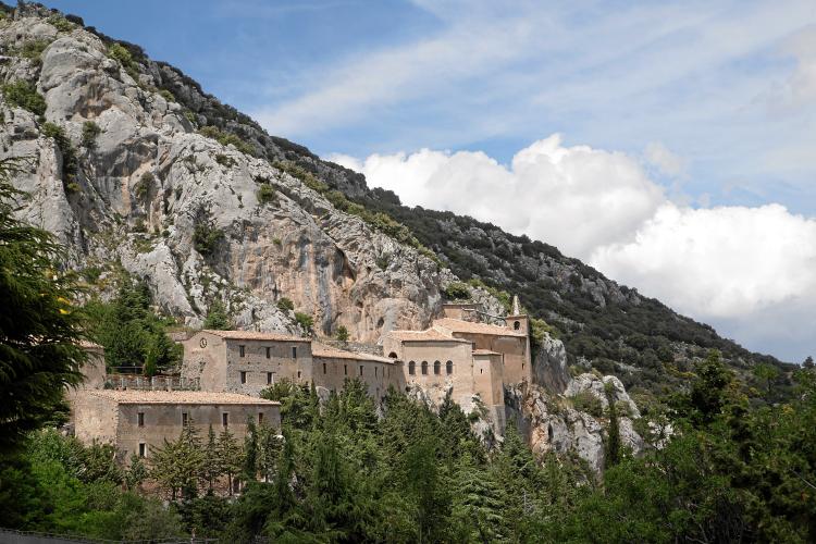
The payoff is the sanctuary itself, built in the 15th century on a Basilian cave documented as early as the 10th century and tucked beneath the cliffs of Monte Sellaro, with a terrace looking out over the Sibari plain and the Ionian Sea. Its main celebrations fall on 25 April and Pentecost Sunday, so expect more company on the road those days.
PLAN YOUR ROUTE
 We've partnered with Sherpa-Map.com to bring you the best route planning tool. With a PRO Membership you can use this climb as a reference when creating your route.
8.1% average grade over 11.0 km (6.8 mi). The steepest 100 yards runs at 19.8%, the steepest 500 m (0.3 mi) at 18.2%, the steepest kilometer at 16.3% and the steepest mile (1.6 km) at 15.9%. Over longer stretches it settles down: the steepest 5 km (3.1 mi) averages 10.7% and the steepest 10 km (6.2 mi) 8.6%.
Most of the work is packed into a short section: between 4.0 km and 6.0 km (2.5 mi and 3.7 mi) the road gains 289 m (948 ft) in just 2 km (1.2 mi), an average of 14.5%.
Roadway: Our surface data shows the route paved from start to finish. It is a true mountain climb through the foothills of Pollino National Park, with ramps well above 15% in the fifth and sixth kilometers, so take care on the descent, especially if it is wet.
Traffic: The calendar sets the traffic here. The sanctuary's main celebrations fall on 25 April and Pentecost Sunday, so those days bring the most visitors - pick another day for a quieter ride.
Parking: Francavilla Marittima, with its centre at 273 m (896 ft), is the nearest town of any size, about 4 km (2.5 mi) from the start, and the practical place to leave a car and roll out to the base of the climb.
Gear: With a 16.3% steepest kilometer, a compact crankset paired with a 32- or 34-tooth cog is the sensible choice. You finish almost 900 m (2,900 ft) higher than you start, so bring a light layer for the descent.
Provisions: Fill your bottles and eat in Francavilla Marittima or on the plain before you start, and carry what you need for the climb.
Before heading out on any cycling adventure check out our Things to Bring on a Cycling Trip and use our interactive check list to ensure you don't forget anything.
The climb is named for Civita, an Arbëreshë hill town at 450 m (1,476 ft), founded in the 15th century by Albanian refugees and listed among I Borghi più belli d'Italia. It overlooks the Raganello gorge and the Ponte del Diavolo, and it is known for about fifty ornate chimneys, the comignoli, built between the late 1600s and early 1900s. Our Villapiana - Plataci page covers the food of the neighboring Arbëreshë village of Plataci, so here we stick to the sanctuary side of the valley.
The Santuario di Santa Maria delle Armi was in monastic use by the 10th century, rebuilt in the 15th, and handed to the community of Cerchiara in 1517. It is free to visit. Nearby Cerchiara di Calabria (650 m / 2,133 ft) has Slow Food-recognized bread, the Cave of the Nymphs with its sulphurous waters, and the Bifurto Abyss, a karst cavity 683 m (2,241 ft) deep. The same sanctuary can also be reached from the Cerchiara side - see our Santuario Madonna delle Armi page - and you can see other climbs nearby with our Routes in the Area tool.
ROUTE MAP

MEMBER RATING
CURRENT WEATHER
PJAMM TRIPS ADVENTURE STARTER BUNDLES
Check out PJAMM Adventure's prepackaged (self-guided) cycling trips. They will help you plan, document and conquer your next adventure.
NEARBY CLIMBS (0) RADIAL PROXIMITY
FROM No Climbs Found
MEMBER REVIEWS & COMMENTS
Let us know what you thought of this climb. Signup for our FREE membership to write a review or post a comment.
Already have an account?
LOG IN HERE
