
16.3
PDI
7.1 mi
DISTANCE
2,593 ft
GAINED
6.9 %
AVG. GRADE
FULL CLIMB STATS
INTRO
Most riders know Port de Lers from the long, gentle Massat side. The road up from Vicdessos is the shorter, steeper one, and on a weekday it's often close to empty - riders have counted three cars on the whole way up. From the village to the col at 1517 m (4977 ft) it's 11.5 km (7.1 mi) at 6.9%, with 790 m (2593 ft) of climbing on the D18.
The start is the hard part. The first 2.5 km leave Vicdessos at 8 to 9%, with the sharpest ramps right among the last houses, before you're properly warm. Around km 3, at the turnoff for Suc-et-Sentenac, the grade drops to 3 to 5% for a kilometer and the road narrows into the forest. From there it never quite settles: stretches of 8 to 9% keep coming back between easier bits, all the way to the hairpins near the top. Most of it is shaded, and streams and small waterfalls tumble down beside the road in several places.
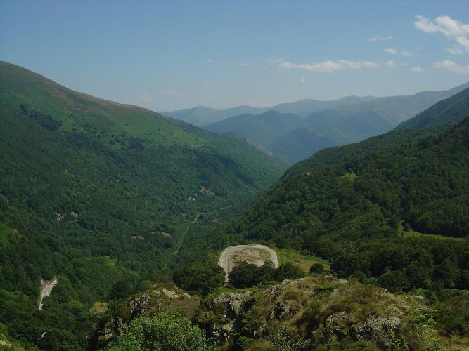
The trees thin out over the last couple of kilometers and the view opens back down the Vicdessos valley - it's at its best about 500 m below the col. The top is open grassland, often windy, with cattle wandering on the road and paragliders launching from the slope just below on good days. The Tour has been coming over Port de Lers since Marco Pantani led the race across in 1995, and in the 2022 Tour it came up this side on stage 16 to Foix, with Simon Geschke first over the top.
PLAN YOUR ROUTE
 We've partnered with Sherpa-Map.com to bring you the best route planning tool. With a PRO Membership you can use this climb as a reference when creating your route.
The climb averages 6.9% over 11.5 km (7.1 mi), but it's rarely steady. The opening 2.5 km out of Vicdessos are the longest steep stretch at 8 to 9%, and riders report short ramps of 12 to 13% in the village itself. The steepest 500 m of the climb averages 10.1%.
Around the Suc-et-Sentenac turnoff (km 3 to 4) the grade falls to 2.5 to 4.6% - the only real breather. From km 4 to 10 it swings between 6 and 9%: 8.5% just after km 5, 8.4% at km 6.5, 9% at km 8 and 9.1% at km 9.5. The steepest kilometer averages 9.2%, the steepest 2 km 8.6% and the steepest 5 km 7.6%. The last kilometer eases to 4 to 5.6% as the road comes out onto the open slopes below the col.
Roadway: The D18 is sealed to the col and on down to the Étang de Lers. New asphalt went down in 2016 and riders have mostly found it smooth since, though one 2023 report calls it grainy. Past the Suc-et-Sentenac turnoff the road narrows to about one car and a bike, with hairpins near the top - easy going up, but take the faster, rougher lower section carefully on the descent. Snow can affect the upper road from late autumn into spring, so check Ariège's Inforoute09 road information before riding outside summer.
Traffic: Light. Above Vicdessos the D18 serves Suc-et-Sentenac, a few farms and the lake on the far side, and riders regularly report only a handful of cars all the way up.
Parking: Park in the center of Vicdessos, a few hundred meters from where the D18 leaves the village (Street View just above the start). Coming by train, Tarascon-sur-Ariège station is about 15 km down the valley, mostly false flat.
Gear: Gear for the first 2.5 km rather than the average: 8 to 9% before you've warmed up is easier on a 34x30 or lower. The col is open and often windy - riders mention a headwind over the final kilometers more than once - so pack a wind jacket for the descent, and gloves in spring or autumn.
Provisions: Fill bottles and buy what you need in Vicdessos - there's nothing on the climb or at the col, and the next shop is down in Massat if you carry on over the top.
Before heading out on any cycling adventure check out our Things to Bring on a Cycling Trip and use our interactive check list to ensure you don't forget anything.
Tarascon-sur-Ariège is the practical base, with the train, shops and places to stay, and the 15 km ride up the valley to Vicdessos makes a good warm-up. On the way you pass Niaux, whose cave holds paintings of bison, horses and ibex made around 17,000 years ago. Visits are guided, by handheld lamp only, must be booked online and take about 1h45 - bring something warm, it's 12°C inside.
From the col you can drop past the Étang de Lers to Massat and come back to Tarascon over the Col de Port, a natural loop, or add the Col d'Agnes, which leaves from the lake. Vicdessos is also the start of our Les Dadels climb to Goulier Neige, and that page covers the village and the valley's iron-mining past.
ROUTE MAP

MEMBER RATING
CURRENT WEATHER
PJAMM TRIPS ADVENTURE STARTER BUNDLES
Check out PJAMM Adventure's prepackaged (self-guided) cycling trips. They will help you plan, document and conquer your next adventure.
NEARBY CLIMBS (0) RADIAL PROXIMITY
FROM No Climbs Found
MEMBER REVIEWS & COMMENTS
Let us know what you thought of this climb. Signup for our FREE membership to write a review or post a comment.
Already have an account?
LOG IN HERE
