Coleman Valley Road West Bike Climb - PJAMM Cycling

6.5
PDI
1.5 mi
DISTANCE
803 ft
GAINED
10.1 %
AVG. GRADE

FULL CLIMB STATS

INTRO

Climbing Coleman Valley Road West by bike is a short but steep and very scenic bike climb in on the Sonoma Coast.    

PLAN YOUR ROUTE

We've partnered with Sherpa-Map.com to bring you the best route planning tool. With a PRO Membership you can use this climb as a reference when creating your route.
There is no "easy" in this climb - the average grade is 9.9% with 61% (0.9 miles) at 5-10% grade and 38% (0.6 miles) at 10-15%.  The steepest quarter-mile is 13%.

See more details and tools regarding this climb's grade via the “Profile Tool” button.
Roadway:  Narrow two lanes without a center line and in rough condition in spots. 

Traffic:  Minimal.

Parking:  Nearly everyone includes this as part of a longer ride, but I have used it for intervals which could prompt someone to park at the start of the climb - parking across Highway 1 from climb start - MapStreet View
Provisions:  There is a market and several locations to get food and beverages In Bodega Bay three miles south, and in Occidental 17 miles east.
Before heading out on any cycling adventure check out our Things to Bring on a Cycling Trip and use our interactive check list to ensure you don't forget anything.
A nice out and back is Occidental to Coleman Valley Road and back - 20 miles 2,700' of climbing (Map).  A 60 mile loop that follows Levi's Gran Fondo Medio Route begins in Santa Rosa (Map).

You can choose from several hotels, inns and boutique resorts in the area.  For longer term stays you may opt for a house rental in Sonoma County. 

ROUTE MAP

MEMBER RATING

Not Yet Rated
-
Road
-
Traffic
-
Scenery

CURRENT WEATHER

PJAMM TRIPS ADVENTURE STARTER BUNDLES

Check out PJAMM Adventure's prepackaged (self-guided) cycling trips. They will help you plan, document and conquer your next adventure.
ALL TRIPS
Browse all of our prepackaged trips and find your next adventure!
San Francisco Bay Area
United States (CA)
25 ROUTES
30 POIs
ROUTE STATS (TOTAL)
487.9
mi
DISTANCE
65,482
ft
ELEV. GAIN
Sonoma County
United States (CA)
19 ROUTES
39 POIs
ROUTE STATS (TOTAL)
269.3
mi
DISTANCE
41,801
ft
ELEV. GAIN

NEARBY CLIMBS (0) RADIAL PROXIMITY

FROM
No Climbs Found

MEMBER REVIEWS & COMMENTS

Let us know what you thought of this climb. Signup for our FREE membership to write a review or post a comment.
Already have an account?
ROUTE MAP
PROFILE TOOL
Route Data
S.G. (%)
hide
Segment Data
hide
CLIMB SUMMARY

Drone photo of Coleman Valley Road bike climb. 

Coleman Valley Road -- A steep climb from the Pacific Coast five miles north of Bodega Bay.

Ride 1.6 miles gaining 801’ to elevation 864’ at 9.5% average grade.

 Sonoma County Top 5 Scenic Bike Climbs

Climb summary submitted by PJAMM Cycling founder and 60 year Sonoma County resident John Johnson.

This climb is the first leg (or last if you travel from Occidental) of one of Sonoma County's cycling jewels -- Coleman Valley Road.  Rivaling Kings Ridge and Geysers Road in its offering of the scenic beauty of Sonoma County, CVR is on our "must do" list for those living in or visiting Sonoma County.  Whether you are here to wine taste, visit, or cycle, you will not regret fitting in the 10.1 miles of CVR between Occidental and Highway 1 (20.2 miles round trip, see the map for more details).  CVR is a main segment of one of the 100 mile Levi's Gran Fondo routes.  The crux of Coleman Valley Road is the first 1.6 miles after turning off Highway 1 and heading east up this epic road and climb.


Climb’s start.

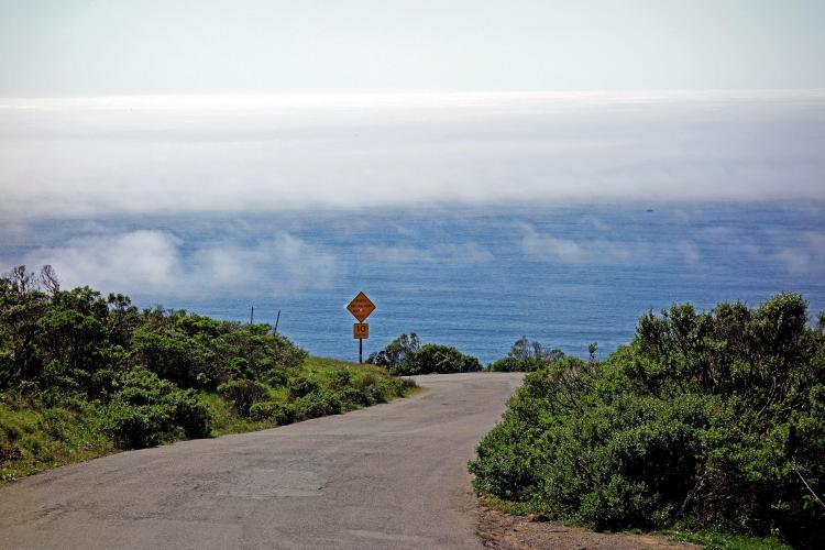
Start of the Coleman Valley Road climb by bike view west to Pacific Ocean, Hwy 1 and road signs.  

Looking west from the start.

Through the cypress tree tunnel just past the start.

View while bicycling up Coleman Valley Road of Pacific Ocean and Hwy 1.  

Exceptional views west as we climb.

.

Finish and top of the Coleman Valley Road bike climb.  

Finish at the cypress trees.

Cycling Coleman Valley Road - aerial drone photo of road and fog over Pacific Ocean

Cycling Coleman Valley Road - aerial drone photo of road and fog over Pacific Ocean

PJAMM Cycling John Johnson and World and National Masters cycling champion Mark Hoffenberg on Coleman Valley Road. 

 1975 Montgomery High School Grad Mark Hoffenberg (right).

World and four-time US Masters cycling champion.

Cycling Coleman Valley Road - aerial drone photo of Mt. St. Helena

Mt. St. Helena in the background -- northeast of Coleman Valley Road.

Coleman Valley Road from Occidental to Hwy 1 and back is my favorite Sonoma County ride.

Coleman Valley School built 1864 - 2 ½ miles west of Occidental on Coleman Valley Road.

Photo far right - Western Sonoma County Historical Society.

The Coleman Valley Road bike climb begins about  2½ miles north of Bodega Bay (population 1,077, 2010) Sonoma County, Northern California. Or, you can come from Occidental:

Occidental is a quaint and fun town with several great restaurants

I have been coming to the Union Hotel for 50 years . . .

. . . went there with my wife, Mark and other friends for Montgomery HS 1975 prom.

Roadway Surface and Traffic Report:  The roadway is in moderately good condition with no shoulder (at points it is more of a wide single lane), but with minimal traffic.

TOUR OF CALIFORNIA: COLEMAN VALLEY ROAD

PJAMM Cycling John Johnson and World and National Masters cycling champion Mark Hoffenberg on Coleman Valley Road.

Coleman Valley Road, Sonoma County, has been included four times in the Tour of California between 2006 and 2019.

  1. 2007 Stage 1
  1. Sausalito > Santa Rosa
  2. 95.2 miles, 5,672’
  3. Stage winner:  Graeme Brown (AUS)
  1. 2008 Stage 1
  1. Sausalito > Santa Rosa
  2. 94.9 miles, 5,428’
  3. Stage winner:  Juan José Haedo (ARG)
  1. 2012 Stage  
  1. Santa Rosa > Santa Rosa
  2. 115.2 miles, 6,345’
  3. Stage winner: Peter Sagan (SVK)
  1. 2016 Stage 7  
  1.  Santa Rosa > Santa Rosa
  2. 108.8 mi 8,600’
  3. Stage winner:  Alexander Kristoff (NO)

That’s a wrap!!