Fort Ross Road West Bike Climb - PJAMM Cycling

11.5
PDI
2.4 mi
DISTANCE
1,356 ft
GAINED
10.8 %
AVG. GRADE

FULL CLIMB STATS

Photos By: Maxfield Bonta

INTRO

The Fort Ross West bike climb is one of our Sonoma County favorites.  This one has it all - views of Sonoma County's Pacific Coast, redwood trees, and STEEEP!!  
Average grade is 10.7% - 1,353' of climbing and 0 descent.  62% of the climb is at 10-15% grade and 7% is at 15-20%.  The steepest quarter-mile is 15.8%. 

See more details and tools regarding this climb's grade via the “Profile Tool” button.
Roadway:  Narrow two lane (well, at spots even one lane) road in fair condition with some rough spots.  Beware of debris on the descent. 

Traffic:  Minimal to 0.

Parking:  Park on the side of the road 50 yards up the climb from Highway 1 - this is where they set up the rest stop for Santa Rosa Cycling Club's Terrible Two double century (Map; Street View).  An alternative is to park in the Fort Ross State Park parking lot directly across the street from the start of our climb, but you must pay a fee for that. 
Provisions:  None on the route.  The closest food and beverages are at the Jenner Sea Store or Cafe Aquatica in Jenner 11.6 miles south of the climb start (route).
Before heading out on any cycling adventure check out our Things to Bring on a Cycling Trip and use our interactive check list to ensure you don't forget anything.
Consider visiting Fort Ross State Park and walking around the old Russian Fort and community preserved on the grounds which is just across Highway 1 from climb start (Map). 

ROUTE MAP

MEMBER RATING

Not Yet Rated
-
Road
-
Traffic
-
Scenery

CURRENT WEATHER

PJAMM TRIPS ADVENTURE STARTER BUNDLES

Check out PJAMM Adventure's prepackaged (self-guided) cycling trips. They will help you plan, document and conquer your next adventure.
ALL TRIPS
Browse all of our prepackaged trips and find your next adventure!
San Francisco Bay Area
United States (CA)
25 ROUTES
30 POIs
ROUTE STATS (TOTAL)
487.9
mi
DISTANCE
65,482
ft
ELEV. GAIN
Sonoma County
United States (CA)
19 ROUTES
39 POIs
ROUTE STATS (TOTAL)
269.3
mi
DISTANCE
41,801
ft
ELEV. GAIN

NEARBY CLIMBS (0) RADIAL PROXIMITY

FROM
No Climbs Found

MEMBER REVIEWS & COMMENTS

Let us know what you thought of this climb. Signup for our FREE membership to write a review or post a comment.
Already have an account?
ROUTE MAP
PROFILE TOOL
Route Data
S.G. (%)
hide
Segment Data
hide

Climb Profile Not Found
CLIMB SUMMARY

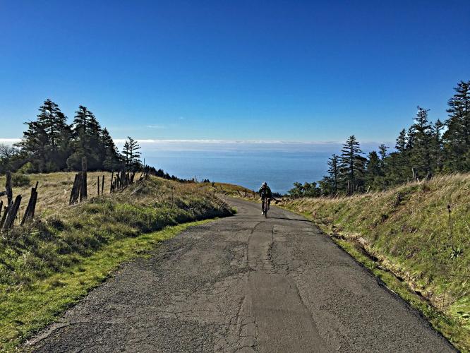
cycling Fort Ross Road - road, fog over Pacific Ocean

Cycling Fort Ross Road - from the west

View west from top of western climb - Pacific Ocean covered with fog

 Sonoma County Top 5 Scenic Bike Climbs

DSC00787.JPG

This climb is the  shortest in the Tri-County Top 10, but has the steepest average grade at 10.9%.  During nearly the entire ride you are surrounded by redwood forest making for a private  and very unique climb.  The smell of the coast and redwoods coupled with the mild  temperatures  make for a very enjoyable ride (aside from the double digit grade over the  entire ascent).  

Bike climb Fort Ross Road - Fort Ross sign on Hwy 1   

Bike climb Fort Ross Road - Fort Ross sign on Hwy 1

 Bike climb Fort Ross Road - 2 cyclists on bikes in redwoods


Traffic/Roadway surface:  This is a narrow effectively one lane road that has very little  traffic.  The road is in fair condition.  Descending can be a bit harrowing as the road has  many sharp turns, rough and gravel surface and is so steep it is very difficult to keep your  speed down.

Bike climb Fort Ross Road - 2 cyclists at top of climb


Steepest ¼ mile begins at mile 4.3 (11.3%)

TOUR OF CALIFORNIA - FORT ROSS ROAD


Peter Sagan (SVK) outsprints the field

Santa Rosa, Stage 1 2012 Tour of California

Photo: Kent Porter / Press Democrat 2012

Fort Ross Road has been featured once in the Tour of California:

  • 2012 Stage 1

That’s a wrap!!