
19.6
PDI
8.4 mi
DISTANCE
3,046 ft
GAINED
6.7 %
AVG. GRADE
FULL CLIMB STATS
INTRO
PLAN YOUR ROUTE
 We've partnered with Sherpa-Map.com to bring you the best route planning tool. With a PRO Membership you can use this climb as a reference when creating your route.
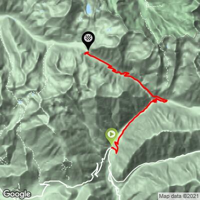
Col de Salèse gains 928 m (3,046 ft) in 13.6 km (8.4 mi), rising from 1,120 m (3,676 ft) to 2,031 m (6,664 ft) for a 6.7% average.
The first 4 km (2.5 mi) are the gentlest, running between 5.0% and 6.2% per kilometer. The fifth kilometer (miles 2.5 to 3.1) jumps to 8.3%, then the road eases for three kilometers, dipping to 3.9% in the seventh as it passes Le Boréon, a natural place to settle in before the second half.
From km 8 (mile 5.0) onward the climb gets serious: each of the last five kilometers runs between 7.8% and 9.0%, and the final 4.5 km (2.8 mi), all on the unpaved section above the Parking de Salèse, average 8.2%. The steepest half-kilometer averages 10.7%, the steepest kilometer 9.6% and the steepest mile 8.9%.
Roadway: The road is paved from the start to the Parking de Salèse, at about 1,660 m (5,446 ft) and 9.0 km (5.6 mi) in, just inside the entrance to Mercantour National Park. Above the lot it becomes an unpaved track for the last 4.5 km (2.8 mi) to the col, rough in places and signed as closed to private vehicles, so check the signs and park rules before you ride it. A gravel bike, or a road bike on the widest tires it will take, makes the top far more comfortable. July to October is the dependable season, and snow usually closes the upper road from November to March.
Traffic: Light overall. The Boréon road below the lot sees the most cars, mostly summer visitors heading for the Boréon lake and the wolf park, and the track above the lot is nearly empty apart from hikers on the Lac Nègre trail.
Parking: Saint-Martin-Vésubie has public parking around the village, and the start is a short roll up the Boréon road from the center. If you want only the unpaved top, the Parking de Salèse is the trailhead lot at the park entrance; it also serves walkers, so arrive early on summer weekends.
Gear: The top 4.5 km (2.8 mi) are unpaved, so a gravel bike, or a road bike with wide tires and a compact gear range, suits this climb best. Pack a layer for the descent: the col is at 2,031 m (6,664 ft), more than 1,000 m (3,300 ft) above Saint-Martin-Vésubie at 975 m (3,199 ft), and the temperature drop is real even in summer.
Provisions: There are no services on the climb itself. Le Boréon, which the route passes at about 1,500 m (4,921 ft) around km 6.5 (mile 4.0), has seasonal food service and is the natural stop before the final push. There is no known drinking water on the trail above the lot, so leave Le Boréon with full bottles.
Before heading out on any cycling adventure check out our Things to Bring on a Cycling Trip and use our interactive check list to ensure you don't forget anything.
Our Col Madone de Fenestre page covers Saint-Martin-Vésubie itself and the sanctuary valley, so this page is about the other branch of the road: the Boréon valley and the Mercantour beyond it. The climb passes Le Boréon, a mountain hamlet around a lake at about 1,500 m (4,921 ft) where the valley opens onto the core zone of the national park. Parking is free, the lake is popular for picnics and fishing, and Alpha, a wolf park, is nearby.
The Parking de Salèse at the park entrance is also the start of the walk to Lac Nègre (2,354 m / 7,723 ft), a dark lake in a granite cirque reached by crossing the Col de Salèse itself: 12.7 km (7.9 mi) round trip with about 743 m (2,438 ft) of climbing. Park rules apply in the core zone - dogs are not allowed and camping is prohibited - and the valley is good country for ibex, chamois, mouflon and marmots.
To see other climbs nearby, or build a custom route from here, use our Routes in the Area tool.
ROUTE MAP
MEMBER RATING
CURRENT WEATHER
PJAMM TRIPS ADVENTURE STARTER BUNDLES
Check out PJAMM Adventure's prepackaged (self-guided) cycling trips. They will help you plan, document and conquer your next adventure.
NEARBY CLIMBS (0) RADIAL PROXIMITY
FROM No Climbs Found
MEMBER REVIEWS & COMMENTS
Let us know what you thought of this climb. Signup for our FREE membership to write a review or post a comment.
Already have an account?
LOG IN HERE
