
24.2
PDI
9.9 mi
DISTANCE
3,760 ft
GAINED
7.2 %
AVG. GRADE
FULL CLIMB STATS
INTRO
Col du Mont Noir from Cognin-les-Gorges climbs 15.9 km (9.9 mi) and gains 1,146 m (3,760 ft) at a 7.2% average grade to reach 1,422 m (4,664 ft) - the highest paved pass in the Vercors massif. Of the mountain's several approaches, this northwest side through the Gorges du Nan is the one riders most often call the most beautiful. It ranks #83 in France by our rankings.
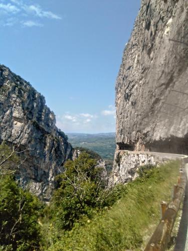
The first half is the showpiece. Within a few kilometers of the village, the D22 is carved straight into the cliff face above the Nan torrent, threading short rock tunnels and running along dizzying balconies guarded by nothing more than a low stone wall. Above the gorge the road reaches the small village of Malleval-en-Vercors at roughly the halfway point, then climbs a set of hairpins up through the Pas de Pré Coquet and on into the dense forest of the Coulmes for the long, steady finish.
Malleval carries real weight. At dawn on 29 January 1944, German mountain troops and the Milice surrounded the Resistance maquis sheltering here, killing dozens of fighters and villagers and burning much of the village; the stone memorial known as Le Gisant honors them. Traffic is light the whole way, and above the gorge it's quiet forest riding - snow can linger in the Coulmes into spring, so check conditions with our Weather tool before an early-season attempt.
PLAN YOUR ROUTE
 We've partnered with Sherpa-Map.com to bring you the best route planning tool. With a PRO Membership you can use this climb as a reference when creating your route.
 This is one of the most consistent climbs of its size in the Vercors. Over 15.9 km (9.9 mi) the road gains 1,146 m (3,760 ft) at 7.2%, from 277 m (910 ft) to 1,422 m (4,664 ft), and every kilometer from the bottom to km 15 averages between 6.5% and 8.4% - there's no real flat recovery anywhere until the final kilometer eases to about 4.6%.
Nothing is especially steep: the steepest kilometer averages 9.0%, the steepest 0.5 km 9.5%, and the steepest 100 m (0.1 mi) pitch just 13.6%. The steepest 2 km average 8.2% and the steepest 5 km 7.9%. The challenge is the relentlessness, so settle into a rhythm in the gorge and hold it.
Riders who know the climb say it feels hardest through Malleval and on the hairpins above it up to the Pas de Pré Coquet, before the forest section to the top rolls a little more easily.
Roadway: The D22 is paved the whole way, but it's narrow - especially through the Gorges du Nan, where the road is cut directly into the cliff, passes through short rock tunnels, and has only a low parapet on the drop side. Surface quality is mixed, good in places and patched or rough in others, notably higher up in the Coulmes forest. As of September 2026 the Vercors road-status page lists both the Gorges du Nan road (Cognin to Malleval) and the Route des Coulmes (Malleval to Patente) as open, with a 2.95 m tunnel height limit and no vehicles over 3.5 t. The upper Mont Noir road is seasonal and closes in winter, so check Isère's Itinisère road status before an early- or late-season ride.
Traffic: Very light - riders routinely describe meeting only a handful of cars in two hours of climbing. The main thing to watch is oncoming vehicles in the narrow gorge, where passing room is tight.
Parking: Cognin-les-Gorges has a large parking area by the church at the bottom of the village, a few hundred meters from where the D22 starts climbing - it's also the trailhead for the popular walking loop into the Gorges du Nan, so it can fill up on summer weekends.
Gear: Because the grade is so steady, gearing here is about finding a ratio you can turn for 90 minutes to two hours rather than bailing out of a wall - a compact crankset with a 30-32-tooth cog suits most riders. A little extra puncture protection helps on the patchier forest sections, and a small light is worth carrying for the gorge tunnels. The lower gorge can get hot on summer afternoons.
Provisions: Auberge Les Galopins in Malleval-en-Vercors, roughly halfway up, is a family-run inn and restaurant cooking with local and organic produce, with a shaded terrace - the one place on the route for a proper meal or a drink, though it's worth checking opening days before counting on it. Otherwise, stock up in Cognin-les-Gorges before you start.
Before heading out on any cycling adventure check out our Things to Bring on a Cycling Trip and use our interactive check list to ensure you don't forget anything.
Cognin-les-Gorges is a small, restored village where the Vercors cliffs meet the Isère valley, a quiet base with Saint-Marcellin and Grenoble's bigger range of hotels and bike shops a short drive away. The Gorges du Nan are a destination beyond the bike too - the Nan torrent has carved a deep limestone canyon with waterfalls, and a well-known walking loop starts from the village church.
In Malleval, take a few minutes at Le Gisant, the reclining stone figure carved from local limestone by sculptor Michel Chauvet, which rests against the cliff at the edge of the village. It's one of the Vercors Resistance memorial sites, and the village's story is a sobering counterpoint to the scenery.
For a loop, our Col du Mont Noir (Saint-Gervais) and Col du Mont Noir (Saint-Pierre-de-Chérennes) pages cover the Écouges and Le Faz sides of the same mountain - descending via the Écouges drops you back into the valley at Saint-Gervais, just a short ride east of Cognin.
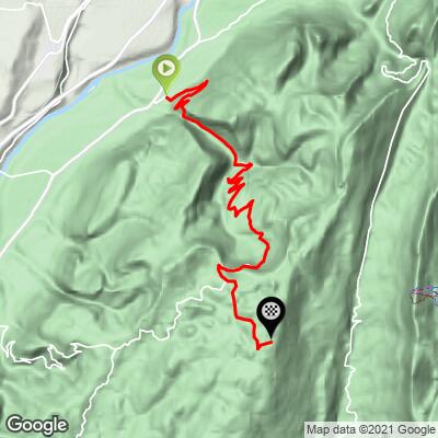
ROUTE MAP
MEMBER RATING
CURRENT WEATHER
PJAMM TRIPS ADVENTURE STARTER BUNDLES
Check out PJAMM Adventure's prepackaged (self-guided) cycling trips. They will help you plan, document and conquer your next adventure.
NEARBY CLIMBS (0) RADIAL PROXIMITY
FROM No Climbs Found
MEMBER REVIEWS & COMMENTS
Let us know what you thought of this climb. Signup for our FREE membership to write a review or post a comment.
Already have an account?
LOG IN HERE
