
18.3
PDI
8.1 mi
DISTANCE
2,912 ft
GAINED
6.9 %
AVG. GRADE
FULL CLIMB STATS
INTRO
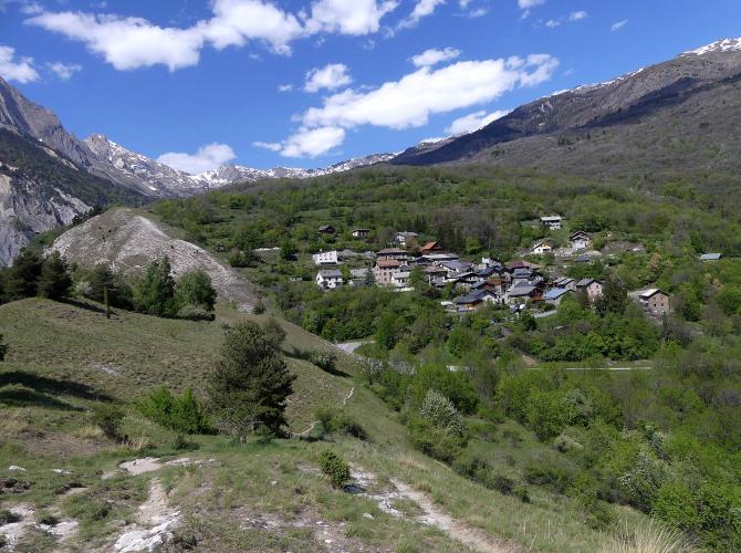
St. Michael - La Villette - Beaune is the western road up to the Beaune hamlets above Saint-Michel-de-Maurienne. From the edge of town at 708 m (2,322 ft) it climbs 13.0 km (8.1 mi) and gains 888 m (2,912 ft) at a 6.9% average grade, finishing on the slope above Beaune at 1,595 m (5,232 ft). It ranks #220 in France by our rankings.
Where our St. Michael - Beaune climb goes straight up through La Traversaz and Le Thyl, this one swings west into the neighboring commune of Saint-Martin-de-la-Porte. It passes the hamlet of La Porte, follows the Route des Alpages through La Villette, and crests the little Col de Beaune (1,205 m / 3,953 ft) on the D 219 before turning back east through Le Mollard and Beaune itself. The two climbs meet at the Col de Beau Plan, at about 1,420 m (4,659 ft), and share the last 3 km (1.9 mi).
The grade is about as even as a mountain road gets. Nearly every kilometer sits between 6% and 8%, the steepest kilometer averages 8.6%, and the only real breather comes just after the Col de Beau Plan. It's hamlet roads all the way, with very little traffic - a quiet counterpoint to the Télégraphe road on the other side of the valley.
PLAN YOUR ROUTE
 We've partnered with Sherpa-Map.com to bring you the best route planning tool. With a PRO Membership you can use this climb as a reference when creating your route.
St. Michael - La Villette - Beaune averages 6.9% over 13.0 km (8.1 mi), gaining 888 m (2,912 ft) from 708 m (2,322 ft) to 1,595 m (5,232 ft).
The steepest 100 m (109 yd) reaches 10.3%, the steepest 500 m (0.3 mi) averages 9.2% and the steepest kilometer averages 8.6%. The hardest of that comes early, on the Route de la Balme between roughly km 1.4 and km 2.4, as the road climbs out of Saint-Michel toward La Porte.
After that the climb barely changes character. The steepest 2 km (1.2 mi) average 7.9%, the steepest 5 km (3.1 mi) 7.2% and the steepest 10 km (6.2 mi) 7.0% - almost exactly the overall average. Every full kilometer up to the Col de Beau Plan averages between 6.1% and 8.0%. The one easier kilometer comes right after the col, at about 4.9%, before a final push at just over 7% to the finish.
Roadway: Paved the entire way. The first kilometers use residential streets and the Route de la Balme on the west side of Saint-Michel, then the climb moves onto small hamlet roads - the Route des Alpages through La Villette and the D 219 over the Col de Beaune - with tighter lanes than the valley roads. The final 3 km (1.9 mi) from the Col de Beau Plan are shared with our St. Michael - Beaune climb, on roads Maurienne Tourisme describes as in good condition and generally open from 15 March to 15 November, depending on snow and weather.
Traffic: Very light - mostly local traffic for the hamlets of Saint-Martin-de-la-Porte and Beaune. The D 219 around the Col de Beaune is also used by cyclists as a quieter alternative to the busy D1006 valley road, so you may share it with other riders more than with cars.
Parking: Our St. Michael - Beaune page covers parking in the centre of Saint-Michel-de-Maurienne, secure bike parking at Espace Alu, and the car park at the entrance to Beaune for anyone starting higher up. This climb starts about 1 km (0.6 mi) west of the centre on Avenue du Vigny, a residential street, so the simplest plan is to park in town and ride out to the start rather than leaving a car in the residential lanes.
Provisions: Fill your bottles and buy food in Saint-Michel-de-Maurienne before you start - the route passes only small hamlets, and the nearest bike repair listed by Maurienne Tourisme is down the valley in Saint-Jean-de-Maurienne, so carry a spare tube and tools.
Gear: With nothing much above 9% for more than a few hundred meters, a compact chainset with a 28- to 32-tooth largest cog is plenty for most riders. You finish almost 900 m (2,950 ft) above the start, so pack a layer for the descent, especially early or late in the mid-March to mid-November season.
Before heading out on any cycling adventure check out our Things to Bring on a Cycling Trip and use our interactive check list to ensure you don't forget anything.
This climb spends its middle section in Saint-Martin-de-la-Porte, a commune most visitors only see from the valley road. Its chef-lieu, about 1 km (0.6 mi) west of La Villette and reached by continuing down the D 219 from the Col de Beaune, is worth the short detour for the Église Saint-Martin: a Romanesque nave inside a church enlarged in the 15th and 17th centuries, with a 17th-century main altarpiece and a bulb-topped steeple that is unusual for the Maurienne.
Beaune itself was a commune in its own right until 1972, when it and Le Thyl were attached to Saint-Michel-de-Maurienne. From the Beaune hamlets a separate, much harder road continues up toward La Saussaz, at about 2,090 m (6,857 ft) beneath the Croix des Têtes; riders describe repeated walls well into double digits and broken pavement near the top, so treat it as a serious add-on rather than a natural extension of this ride.
For a loop, you can ride this climb up, then descend the D 219 west from the Col de Beaune through Saint-Martin-de-la-Porte and return to Saint-Michel along the valley. For Espace Alu, the hamlets of La Traversaz and Le Thyl and gîte stays in Beaune, see our St. Michael - Beaune page.
ROUTE MAP

MEMBER RATING
CURRENT WEATHER
PJAMM TRIPS ADVENTURE STARTER BUNDLES
Check out PJAMM Adventure's prepackaged (self-guided) cycling trips. They will help you plan, document and conquer your next adventure.
NEARBY CLIMBS (0) RADIAL PROXIMITY
FROM No Climbs Found
MEMBER REVIEWS & COMMENTS
Let us know what you thought of this climb. Signup for our FREE membership to write a review or post a comment.
Already have an account?
LOG IN HERE
