
19.7
PDI
17 mi
DISTANCE
4,151 ft
GAINED
4.4 %
AVG. GRADE
FULL CLIMB STATS
INTRO
Col du Somport from Accous is a 27.3 km (17.0 mi) climb that gains 1,265 m (4,151 ft) at a 4.4% average grade, rising from 444 m (1,458 ft) in the Aspe valley to the Spanish border at 1,632 m (5,354 ft). It is a patient valley road rather than a ladder of hairpins, and the grade tells the story: the first 12 km (7.5 mi) average only 2.3%, and the real climbing is saved for the end.
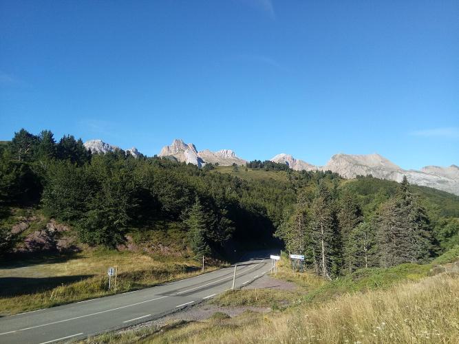
The N134 follows the Gave d'Aspe south from Accous through Cette-Eygun, Borce and Urdos. Past Urdos, the old Route du Col leaves the road to the Somport tunnel and climbs through the Pyrenees National Park, where the last 7.3 km (4.5 mi) average 7.0% and the steepest kilometer reaches 8.7%. Since the 8.6 km (5.3 mi) road tunnel opened in 2003, most trucks and through traffic bypass the pass entirely, which leaves the old road above Urdos far quieter than the valley below it.
The Somport has been a gateway between France and Aragon for centuries, and it is one of the classic routes for pilgrims on the Way of St. James, linking Oloron-Sainte-Marie with Jaca. At the top, a former border post and the cross-country trails of the Somport Nordic area mark the frontier, with the Spanish ski resort of Candanchú a few kilometers down the other side. Storms on 6-7 September 2024 collapsed the N134 south of Urdos; it reopened on 20 December 2024 and the climb is fully rideable again.
PLAN YOUR ROUTE
 We've partnered with Sherpa-Map.com to bring you the best route planning tool. With a PRO Membership you can use this climb as a reference when creating your route.
Col du Somport averages 4.4% over 27.3 km (17.0 mi), gaining 1,265 m (4,151 ft), but it is really three climbs in one.
Km 0-12 (0-7.5 mi): 2.3% - an easy valley road from Accous through Cette-Eygun and Borce, with only the occasional steeper kick.
Km 12-20 (7.5-12.4 mi): 5.0% - the valley narrows and the grade steadies as the climbing begins in earnest.
Km 20-27.3 (12.4-17.0 mi): 7.0% - the old road above Urdos is where the climb is won or lost.
Km 12-20 (7.5-12.4 mi): 5.0% - the valley narrows and the grade steadies as the climbing begins in earnest.
Km 20-27.3 (12.4-17.0 mi): 7.0% - the old road above Urdos is where the climb is won or lost.
The steepest 500 m averages 9.6%, the steepest kilometer (0.6 mi) 8.7%, the steepest 2 km (1.2 mi) 8.0%, the steepest 5 km (3.1 mi) 7.2% and the steepest 10 km (6.2 mi) 6.6%. The single steepest 100 yards (91 m) reaches 10.6%. Save something for the top: riders report strong headwinds over the last few kilometers.
Roadway: Both the N134 up the valley and the old Route du Col above Urdos are paved the entire way. The lower road is wide with gentle grades; the upper road is narrower and winds up through hairpins to the pass. The N134 was cut by a road collapse south of Urdos after storms on 6-7 September 2024 and reopened to traffic on 20 December 2024. At 1,632 m (5,354 ft) the pass sees snow and ice from late autumn into spring, so check current N134 and Somport conditions on Bison Futé before an early- or late-season ride.
Traffic: Traffic is heavy on the N134 in the lower valley, especially toward the tunnel entrance, where trucks use the road. Above the turn-off for the old road, traffic drops sharply. Riders recommend Sunday mornings, when there are fewer trucks.
Parking: Accous is a small Aspe valley village on the N134, with parking on its streets and roadside pull-offs rather than a dedicated cyclist lot. Bedous, a few kilometers down-valley, is the valley's service hub with the tourist office - see our Super Lescun page for what it offers.
Gear: Standard compact gearing is plenty - the steepest sustained stretches sit around 7-9%. Bring a windproof layer: the upper road is exposed, headwinds are common over the last few kilometers, and the descent is cold even in summer. Carry ID if you plan to continue into Spain.
Provisions: Fill your bottles in Accous before you start and carry enough water and food for the upper road, where the climb leaves the villages behind.
Before heading out on any cycling adventure check out our Things to Bring on a Cycling Trip and use our interactive check list to ensure you don't forget anything.
The Aspe valley's base town, Bedous, is covered on our Super Lescun page, so here are the stops that belong to the Somport end of the valley. Just downriver from Urdos, the Fort du Portalet clings to a cliff above the Gave d'Aspe at 765 m (2,510 ft). Louis-Philippe ordered it built in 1842 to guard the border, and in 1940 the Vichy regime used it as a prison for figures including Léon Blum, Édouard Daladier and Paul Reynaud - ask the Aspe valley tourist office in Bedous about visiting.
At the top, the Camino de Santiago crosses the pass on its way to Canfranc and Jaca. Canfranc's grand International Railway Station, the terminus of the Pau-Canfranc line, lost its international service after an accident in 1970 and is a worthwhile detour on the Spanish side. If you want a long Pyrenean valley road for comparison, see our Col du Pourtalet page. Conditions at the top can differ sharply from the valley floor, so check our Weather tool before you go.
ROUTE MAP

MEMBER RATING
CURRENT WEATHER
PJAMM TRIPS ADVENTURE STARTER BUNDLES
Check out PJAMM Adventure's prepackaged (self-guided) cycling trips. They will help you plan, document and conquer your next adventure.
NEARBY CLIMBS (0) RADIAL PROXIMITY
FROM No Climbs Found
MEMBER REVIEWS & COMMENTS
Let us know what you thought of this climb. Signup for our FREE membership to write a review or post a comment.
Already have an account?
LOG IN HERE
