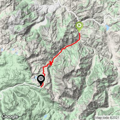
Ebbetts Pass East Bike Climb - PJAMM Cycling

6
FIETS
11.4 mi
DISTANCE
2,958 ft
GAINED
4.9 %
AVG. GRADE

FULL CLIMB STATS

INTRO

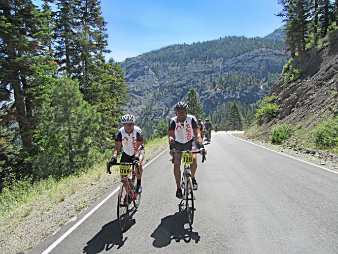
Ebbetts East - This climb begins about 1.8 miles from Highway 4's junction with Highway 89 (Monitor Pass), at the beginning of the bridge over the East Fork of the Carson River.  This has the steepest segments of the five ascents of the annual Death Ride.  See PJAMM Markleeville - Death Ride for data and details regarding the Death Ride.

Our PJAMM App preloaded Death Road trip page is accessed below. 
Average grade is 4.9% and, while 48% of the route is in the 0-5% gradient range, 40% is at 5-10%, 6% is at 10-15%, and a fraction bumps briefly above 15%.  The steepest quarter-mile is 10.2% and steepest one-half mile is 9.8%.  

See more details and tools regarding this climb's grade via the “Profile Tool” button.
Roadway:  Good condition; two lanes with a center strips. 

Traffic:  Minimal.

Parking:   If you are not riding from Markleeville for this climb, park near the bridge over the East Fork of the Carson River, just a few hundred yards from the beginning of the climb - Map; Street View.
Provisions;  There are none on the ride.  The nearest food, beverages and meals are in Markleeville, seven miles northwest. 
Before heading out on any cycling adventure check out our Things to Bring on a Cycling Trip and use our interactive check list to ensure you don't forget anything.
We have always stayed in Markleeville for the climbs in the area (PJAMM Climb page: Markleeville - Death Ride).  While lodging choices are limited in Markleeville there is a wide variety of resorts and hotels in nearby Lake Tahoe.  The are also plenty of homes and cabins to rent in and around Lake Tahoe for longer visits.  

The annual Death Ride is a wildly popular bike climbing event which you should consider trying if you enjoy climbing by bike - beware though, it is an extremely difficult event - Official Website

ROUTE MAP

MEMBER RATING

Difficulty: Challenging
5
Road
5
Traffic
5
Scenery

CURRENT WEATHER

PJAMM TRIPS ADVENTURE STARTER BUNDLES

Check out PJAMM Adventure's prepackaged (self-guided) cycling trips. They will help you plan, document and conquer your next adventure.
ALL TRIPS
Browse all of our prepackaged trips and find your next adventure!
Death Ride (Tour of the California Alps)
United States (CA)
7 ROUTES
19 POIs
ROUTE STATS (TOTAL)
104.2
mi
DISTANCE
14,111
ft
ELEV. GAIN
Lake Tahoe
United States (CA,NV)
18 ROUTES
32 POIs
ROUTE STATS (TOTAL)
245.7
mi
DISTANCE
35,240
ft
ELEV. GAIN
Owens Valley: Bishop
United States (CA)
19 ROUTES
26 POIs
ROUTE STATS (TOTAL)
268.3
mi
DISTANCE
55,531
ft
ELEV. GAIN
Yosemite National Park
United States (CA)
29 ROUTES
33 POIs
ROUTE STATS (TOTAL)
376
mi
DISTANCE
42,565
ft
ELEV. GAIN

NEARBY CLIMBS (0) RADIAL PROXIMITY

FROM
No Climbs Found

MEMBER REVIEWS & COMMENTS

Let us know what you thought of this climb. Signup for our FREE membership to write a review or post a comment.
Already have an account?

Jul 27, 2021
difficulty: Challenging
scenery: 5
traffic: 5
road: 5
Jul 27, 2021
scenery: 5
traffic: 5
road: 5
One of my favourite rides for its lack of traffic (and slow moving if any due to the winding road!) spectacular.
ROUTE MAP
PROFILE TOOL
Route Data
S.G. (%)
hide
Segment Data
hide

Climb Profile Not Found
CLIMB SUMMARY

Cycling Ebbetts Pass - aerial drone video of the mountain and snow

Cycling Ebbetts Pass East

Ride 11.4 miles gaining 2,950’ at 5% average grade.

Photo:  Ebbets East leading to Kinney Reservoir near summit.

Climb summary by PJAMM’s John Johnson.

Visit our Death Ride page for detailed information on each route and climb in this grueling ride.

This climb begins about 1.8 miles from the junction of Highway 4 with Highway 89 (Monitor Pass), at the beginning of the   bridge over the East Fork of the Carson River.

bike climb Ebbetts Pass - start of climb at bridge 

Start.

     IMG_2335.JPG

We begin this climb after 44.5 miles of riding and 6,525' of climbing. The first 5.5 miles of the climb are very mild (3.1% / +956') while the second half (5.9 miles) is much steeper and frequently includes double digit grades (6.4% / 2,006' / max grade 15.6%).

Cycling Ebbetts Pass - steep grade road sign


The views and scenery are exceptional, and this is our favorite pass of the five. As we ascend we enter and ride into a lovely high sierra alpine setting where there is a gorgeous lake, Kinney Reservoir, 0.8 miles from the summit.  In addition to its aesthetics, Kinney Reservoir is a much welcome sight, as it acts as the signal that the end of this climb is near.

bicycle ride Ebbetts Pass - share the road sign

A very safe place to ride . . .

climbing Ebbetts Pass by bike - road and mountain with trees

. . . and beautiful, too!


cycling Ebbetts Pass - Death Ride cyclists at pass with pass sign 

Ebbetts Pass.

   IMG_2436.JPG

Sign just past the summit sign.

Roadway Surface and Traffic: The road is a narrow two lanes, with the center line clearly marked. In April 2014, the roadway surface was good with a few pot holes towards the top of the pass. During the Death Ride, the pass is closed to motor vehicles, but as with all of the first four passes, be very cautious of ascending cyclists on your descent -- the ride’s organizers even write warnings on the descent ("slow", "slower", and "slowest" -- see our slideshow -- grab the attention of riders as they approach hazardous turns while descending).

MARKLEEVILLE BIKE CLIMBS + DEATH RIDE

Photo - from upper left clockwise:

Ebbetts Pass East; Monitor Pass West; Ebbetts Pass West. and Monitor Pass East.

That’s a wrap!!

Access to full Climb Summary requires a PJAMM Cycling PRO Membership!

It takes less than a minute to sign up & with your PRO membership you can:
  • Rate climbs, post comments and share your experiences on any of our climb pages
  • Create bucket lists of climbs & mark the dates you complete them
  • Weather data for all climbs - Start & Finish
  • Upload photos to your member page to customize your PJAMM Cycling experience
  • Utilize all of our interactive tools - Profile & Routes in Area
  • Download climb route .gpx files
LEARN MORE
SIGN UP

Already have an account? LOG IN HERE