
19.6
PDI
5.6 mi
DISTANCE
2,627 ft
GAINED
8.9 %
AVG. GRADE
FULL CLIMB STATS
INTRO
PLAN YOUR ROUTE
 We've partnered with Sherpa-Map.com to bring you the best route planning tool. With a PRO Membership you can use this climb as a reference when creating your route.
Col de Burdincurutcheta gains 801 m (2,627 ft) in 9.0 km (5.6 mi) for an 8.9% average, rising from 326 m (1,068 ft) to 1,124 m (3,688 ft).
The first 4 km (2.5 mi) are relentless: kilometer by kilometer they run 10.6%, 10.6%, 10.2% and 11.8%, so the opening averages 10.8%. The fifth kilometer (miles 2.5 to 3.1) is the one real breather at 4.2%.
Then it tilts up again: kilometers 6 to 8 (miles 3.1 to 5.0) run 8.7%, 8.6% and 9.6%, and the final kilometer relaxes to 5.7%. The steepest half-kilometer averages 12.8%, the steepest kilometer 12.0%, the steepest 2 km (1.2 mi) 11.4% and the steepest 5 km (3.1 mi) 9.7%.
Roadway: The road is paved to the col, and riders describe the surface as in good condition and wide enough for two lanes, with the odd pothole and sheep or cattle wandering onto the asphalt. Riders describe the descent as narrow and fast, with steep sections that call for early braking, and some report a rougher surface on the stretch toward Saint-Jean-Pied-de-Port, so take it carefully.
Traffic: Low, even in summer. Livestock is a bigger consideration than cars. In autumn the ridges around the col are known for wood-pigeon (palombe) hunting, with hunters' posts along the crest, so expect a little more activity there at that time of year.
Parking: Bassaburua is a hamlet and Mendive a village of about 160 people, so there is no dedicated cycling lot at the start. The easiest option is Saint-Jean-le-Vieux, where you can park near the fronton opposite the town hall and church, with shops and water close by, then roll about 10 km (6.2 mi) of nearly flat road through Ahaxe, Lecumberry and Mendive to the foot of the climb.
Gear: Low gearing earns its keep here. With the first 4 km (2.5 mi) above 10%, a compact crankset with a 30-tooth or larger rear cog is a sensible choice. The first half is shaded forest, but the upper slopes are exposed, so bring sun protection and a wind layer for the ridge.
Provisions: Carry two bottles in warm weather; riders report real heat on the exposed upper slopes. There is no food on the climb. A restaurant a few kilometers past the col in the Iraty forest, covered on our Arnoztegiko Lepoa page, is the usual refill stop.
Before heading out on any cycling adventure check out our Things to Bring on a Cycling Trip and use our interactive check list to ensure you don't forget anything.
Mendive is a small Basque village at the foot of the mountain - its Basque name, Mendibe, means roughly that - with a 12th-century church dedicated to Saint-Vincent-de-Dax and two prehistoric dolmens, one of them (Gasteynia) at Bassaburua, the hamlet where this climb begins.
Our Col d'Errozate and Arnoztegiko Lepoa pages cover the Estérençuby side of the ridge, Saint-Jean-Pied-de-Port as a base and the Chalet Pedro stop, so this page is about the Mendive and Iraty side. A short ride past the col brings you into the Iraty forest, a vast beech forest that straddles the French-Spanish border, and to the 12th-century Saint-Sauveur d'Iraty chapel at about 900 m (2,953 ft), once a stop on the route to Santiago de Compostela.
Birdwatchers should note that the ridge is a migration corridor: an environmental group rents part of the col to count migratory birds, and the nearby Col d'Organbidexka has an LPO observation post. For a bigger day, riders link the col with the Iraty plateau and return via Estérençuby, a loop of roughly 60 km (37.3 mi) from Saint-Jean-Pied-de-Port. To see other climbs nearby, or build a custom route from here, use our Routes in the Area tool.
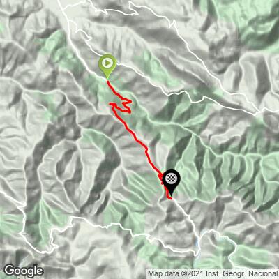
ROUTE MAP
MEMBER RATING
CURRENT WEATHER
PJAMM TRIPS ADVENTURE STARTER BUNDLES
Check out PJAMM Adventure's prepackaged (self-guided) cycling trips. They will help you plan, document and conquer your next adventure.
NEARBY CLIMBS (0) RADIAL PROXIMITY
FROM No Climbs Found
MEMBER REVIEWS & COMMENTS
Let us know what you thought of this climb. Signup for our FREE membership to write a review or post a comment.
Already have an account?
LOG IN HERE
MethowBiker
Don't be deceived by the panneau at the base of this clip which states 5.63% average over 17.5 km. The bottom three miles of this climb are steeper than the Bedoin route up Ventoux. Averaging 11-12%, we saw several short sections of 15%. After that however, it backs off. Also that average includes 4 km of downhill. We saw a condor near the summit! Beautiful area. The descent to Larrau is hair raising, so make sure your brakes are fresh.
